

<< Text Pages >> Parc archéologique des Lozes - Rock Art in France in Rhone:Savoie (73)
Submitted by KaiHofmann on Saturday, 24 August 2013 Page Views: 1691
Rock ArtSite Name: Parc archéologique des LozesCountry: France
NOTE: This site is 8.944 km away from the location you searched for.
Département: Rhone:Savoie (73) Type: Rock Art
Nearest Town: Aussois
Latitude: 45.227750N Longitude: 6.754370E
Condition:
| 5 | Perfect |
| 4 | Almost Perfect |
| 3 | Reasonable but with some damage |
| 2 | Ruined but still recognisable as an ancient site |
| 1 | Pretty much destroyed, possibly visible as crop marks |
| 0 | No data. |
| -1 | Completely destroyed |
| 5 | Superb |
| 4 | Good |
| 3 | Ordinary |
| 2 | Not Good |
| 1 | Awful |
| 0 | No data. |
| 5 | Can be driven to, probably with disabled access |
| 4 | Short walk on a footpath |
| 3 | Requiring a bit more of a walk |
| 2 | A long walk |
| 1 | In the middle of nowhere, a nightmare to find |
| 0 | No data. |
| 5 | co-ordinates taken by GPS or official recorded co-ordinates |
| 4 | co-ordinates scaled from a detailed map |
| 3 | co-ordinates scaled from a bad map |
| 2 | co-ordinates of the nearest village |
| 1 | co-ordinates of the nearest town |
| 0 | no data |
Be the first person to rate this site - see the 'Contribute!' box in the right hand menu.
Internal Links:
External Links:
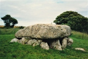
Archaeological parc with rock engravings.
Aussois, Saint-Jean-de-Maurienne, Savoie, Auvergne-Rhône-Alpes
You may be viewing yesterday's version of this page. To see the most up to date information please register for a free account.
Do not use the above information on other web sites or publications without permission of the contributor.
Nearby Images from Flickr

The above images may not be of the site on this page, but were taken nearby. They are loaded from Flickr so please click on them for image credits.
Click here to see more info for this site
Nearby sites
Click here to view sites on an interactive map of the areaKey: Red: member's photo, Blue: 3rd party photo, Yellow: other image, Green: no photo - please go there and take one, Grey: site destroyed
Download sites to:
KML (Google Earth)
GPX (GPS waypoints)
CSV (Garmin/Navman)
CSV (Excel)
To unlock full downloads you need to sign up as a Contributory Member. Otherwise downloads are limited to 50 sites.
Turn off the page maps and other distractions
Nearby sites listing. In the following links * = Image available
2.4km NNE 27° Sardieres Monolithe Natural Stone / Erratic / Other Natural Feature
5.3km NE 48° Musée Archéologique (Sollieres) Museum
14.5km ENE 64° Pierre Gravée (St Pierre) Rock Art
15.4km NE 50° La Pierre aux Pieds Rock Art
15.4km NE 50° Pierre à Cupules dite Le Rocher aux Pieds Rock Art
16.4km ENE 68° Pierre Gravée (Crosats) Rock Art
17.4km ENE 66° La Pierre des Saints Rock Art
20.3km W 271° Pierre à Cupules du Perthuit Rock Art
20.3km W 269° Dolmen du Thyl* Cave or Rock Shelter
20.5km W 272° Pierre à Cupules du Pré Bérard Rock Art
20.6km W 268° Roche gravée du Thyl-Dessous Rock Art
21.3km ESE 121° Museo e Area Archeologica della Maddalena di Chiomonte Museum
21.5km NNW 331° Menhir des Verdons* Standing Stone (Menhir)
21.5km ESE 122° Necropolis la Maddalena* Barrow Cemetery
24.6km NNW 341° Site du Moulin de Bozel Ancient Village or Settlement
25.1km ENE 58° Les Peintures du Rocher du Château* Rock Art
25.3km NNW 347° Champagny 1 Rock Art
25.5km NNW 345° Tincave 1 Rock Art
25.6km NNW 343° Tincave 2 Rock Art
25.6km NNE 20° Col des Ves* Standing Stone (Menhir)
32.0km NNW 329° Pierre de Feisson Rock Art
32.0km NNW 329° Pierre à cupules de Feisson sur Salin Rock Art
34.1km N 352° Dolmen de Nantfrozin Burial Chamber or Dolmen
35.0km SSW 197° Pierre à cupules dite la Pierre aux Oeufs Rock Art
47.4km SE 142° Roccia del Mago* Rock Art
View more nearby sites and additional images


 We would like to know more about this location. Please feel free to add a brief description and any relevant information in your own language.
 Wir möchten mehr über diese Stätte erfahren. Bitte zögern Sie nicht, eine kurze Beschreibung und relevante Informationen in Deutsch hinzuzufügen.
 Nous aimerions en savoir encore un peu sur les lieux. S'il vous plaît n'hesitez pas à ajouter une courte description et tous les renseignements pertinents dans votre propre langue.
 Quisieramos informarnos un poco más de las lugares. No dude en añadir una breve descripción y otros datos relevantes en su propio idioma.