

<< Text Pages >> Centrum Athanor - Modern Stone Circle etc in Netherlands in Gelderland
Submitted by XIII on Friday, 17 March 2017 Page Views: 889
Modern SitesSite Name: Centrum AthanorCountry: Netherlands
NOTE: This site is 5.28 km away from the location you searched for.
Province: Gelderland Type: Modern Stone Circle etc
Nearest Town: Lochem
Latitude: 52.192587N Longitude: 6.450903E
Condition:
| 5 | Perfect |
| 4 | Almost Perfect |
| 3 | Reasonable but with some damage |
| 2 | Ruined but still recognisable as an ancient site |
| 1 | Pretty much destroyed, possibly visible as crop marks |
| 0 | No data. |
| -1 | Completely destroyed |
| 5 | Superb |
| 4 | Good |
| 3 | Ordinary |
| 2 | Not Good |
| 1 | Awful |
| 0 | No data. |
| 5 | Can be driven to, probably with disabled access |
| 4 | Short walk on a footpath |
| 3 | Requiring a bit more of a walk |
| 2 | A long walk |
| 1 | In the middle of nowhere, a nightmare to find |
| 0 | No data. |
| 5 | co-ordinates taken by GPS or official recorded co-ordinates |
| 4 | co-ordinates scaled from a detailed map |
| 3 | co-ordinates scaled from a bad map |
| 2 | co-ordinates of the nearest village |
| 1 | co-ordinates of the nearest town |
| 0 | no data |
Be the first person to rate this site - see the 'Contribute!' box in the right hand menu.
Internal Links:
External Links:
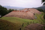
Modern Stone Circle at Centrum Athanor in Lochem, Gelderland.
Website: link (under construction at time of posting)
You may be viewing yesterday's version of this page. To see the most up to date information please register for a free account.
Do not use the above information on other web sites or publications without permission of the contributor.
Nearby Images from Flickr
The above images may not be of the site on this page, but were taken nearby. They are loaded from Flickr so please click on them for image credits.
Click here to see more info for this site
Nearby sites
Click here to view sites on an interactive map of the areaKey: Red: member's photo, Blue: 3rd party photo, Yellow: other image, Green: no photo - please go there and take one, Grey: site destroyed
Download sites to:
KML (Google Earth)
GPX (GPS waypoints)
CSV (Garmin/Navman)
CSV (Excel)
To unlock full downloads you need to sign up as a Contributory Member. Otherwise downloads are limited to 50 sites.
Turn off the page maps and other distractions
Nearby sites listing. In the following links * = Image available
5.6km NNE 33° Long Tom (Markelo) Natural Stone / Erratic / Other Natural Feature
6.5km NE 51° Grafheuvel Markelo (45793)* Round Barrow(s)
6.8km NE 49° Grafheuvels Markelo (45794)* Round Barrow(s)
6.8km NE 53° Grafheuvels Markelo (45795)* Round Barrow(s)
6.9km NE 52° Grafheuvels Markelo (45796)* Round Barrow(s)
7.1km NE 51° Grafheuvels Markelo (45797)* Round Barrow(s)
7.1km NE 39° Grafheuvel Herike (45799) Round Barrow(s)
7.3km NE 40° Grafheuvels Herike (45800) Round Barrow(s)
7.5km NE 50° Grafheuvels Herike (45798)* Round Barrow(s)
8.3km NNE 23° Grafheuvel Elsen (45784) Round Barrow(s)
8.6km NNE 27° Grafheuvel Elsen (45785)* Round Barrow(s)
8.8km NNE 20° Elsenerveld (531050) Ancient Village or Settlement
8.8km NNE 16° Grafheuvels Markelo (45782)* Round Barrow(s)
9.1km NNE 20° Grafheuvel Markelo (45783)* Round Barrow(s)
9.2km N 2° Grafheuvel Holten (45544) Round Barrow(s)
9.2km NNE 28° Grafheuvels Elsen (45786) Round Barrow(s)
9.4km NNE 26° Grafheuvels Elsen (45790)* Round Barrow(s)
9.5km NNE 30° Grafheuvel Elsen (45787)* Round Barrow(s)
9.8km NNE 31° Grafheuvel Elsen (45788) Round Barrow(s)
10.1km NNE 26° Grafheuvels Elsen (45789)* Round Barrow(s)
10.5km NNE 26° Grafheuvel Elsen (45791)* Round Barrow(s)
12.7km WSW 256° Grafheuvel Almen (45423) Round Barrow(s)
15.1km W 265° Grafheuvel Eefde (45424)* Round Barrow(s)
16.1km ESE 123° Grafheuvel Eibergen (524988)* Round Barrow(s)
16.3km SE 132° Grafheuvel Eibergen (524990)* Round Barrow(s)
View more nearby sites and additional images


 We would like to know more about this location. Please feel free to add a brief description and any relevant information in your own language.
 Wir möchten mehr über diese Stätte erfahren. Bitte zögern Sie nicht, eine kurze Beschreibung und relevante Informationen in Deutsch hinzuzufügen.
 Nous aimerions en savoir encore un peu sur les lieux. S'il vous plaît n'hesitez pas à ajouter une courte description et tous les renseignements pertinents dans votre propre langue.
 Quisieramos informarnos un poco más de las lugares. No dude en añadir una breve descripción y otros datos relevantes en su propio idioma.