

<< Text Pages >> Oppenans burial chamber - Burial Chamber or Dolmen in France in Franche:Haute-Saône (70)
Submitted by TheCaptain on Wednesday, 08 September 2010 Page Views: 1865
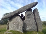
Neolithic and Bronze AgeSite Name: Oppenans burial chamberCountry: France
NOTE: This site is 2.942 km away from the location you searched for.
Département: Franche:Haute-Saône (70) Type: Burial Chamber or Dolmen
Nearest Town: Vesoul Nearest Village: Oppenans
Latitude: 47.589000N Longitude: 6.382000E
Condition:
| 5 | Perfect |
| 4 | Almost Perfect |
| 3 | Reasonable but with some damage |
| 2 | Ruined but still recognisable as an ancient site |
| 1 | Pretty much destroyed, possibly visible as crop marks |
| 0 | No data. |
| -1 | Completely destroyed |
| 5 | Superb |
| 4 | Good |
| 3 | Ordinary |
| 2 | Not Good |
| 1 | Awful |
| 0 | No data. |
| 5 | Can be driven to, probably with disabled access |
| 4 | Short walk on a footpath |
| 3 | Requiring a bit more of a walk |
| 2 | A long walk |
| 1 | In the middle of nowhere, a nightmare to find |
| 0 | No data. |
| 5 | co-ordinates taken by GPS or official recorded co-ordinates |
| 4 | co-ordinates scaled from a detailed map |
| 3 | co-ordinates scaled from a bad map |
| 2 | co-ordinates of the nearest village |
| 1 | co-ordinates of the nearest town |
| 0 | no data |
Be the first person to rate this site - see the 'Contribute!' box in the right hand menu.
Internal Links:
External Links:
burial chamber in Franche:Haute-Saône (70)
Oppenans burial chamber is a burial chamber in the community of Oppenans, Departement of Haute-Saône, Region of Franche-Comté
You may be viewing yesterday's version of this page. To see the most up to date information please register for a free account.
Do not use the above information on other web sites or publications without permission of the contributor.
Nearby Images from Flickr
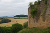
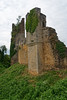
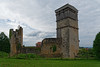
The above images may not be of the site on this page, but were taken nearby. They are loaded from Flickr so please click on them for image credits.
Click here to see more info for this site
Nearby sites
Click here to view sites on an interactive map of the areaKey: Red: member's photo, Blue: 3rd party photo, Yellow: other image, Green: no photo - please go there and take one, Grey: site destroyed
Download sites to:
KML (Google Earth)
GPX (GPS waypoints)
CSV (Garmin/Navman)
CSV (Excel)
To unlock full downloads you need to sign up as a Contributory Member. Otherwise downloads are limited to 50 sites.
Turn off the page maps and other distractions
Nearby sites listing. In the following links * = Image available
1.9km SE 126° Dolmen du Bois de Blusseret 3 Burial Chamber or Dolmen
1.9km ESE 106° Dolmen du Bois de Blusseret 1* Burial Chamber or Dolmen
2.1km ESE 123° Dolmen du Bois de Blusseret 2 Burial Chamber or Dolmen
11.0km WNW 285° Dolmen dit la Pierre qui Vire (Vesoul) Burial Chamber or Dolmen
12.3km S 177° Dolmen du Mont-Roland Burial Chamber or Dolmen
14.0km S 180° Trou du Seri* Cave or Rock Shelter
14.2km S 180° Grotte aux Ours* Cave or Rock Shelter
20.3km WSW 255° Echenoz-le-Sec burial chamber Burial Chamber or Dolmen
21.1km SSE 156° Santoches Dolmen* Burial Chamber or Dolmen
23.1km WSW 248° Dolmen de Courboux Burial Chamber or Dolmen
24.1km WSW 245° Dolmen de Lanjoutot Burial Chamber or Dolmen
25.2km NNE 20° Pierre Mourey Natural Stone / Erratic / Other Natural Feature
27.4km E 82° Menhir dit la Pierre des Gaulois* Standing Stone (Menhir)
28.4km W 276° Dolmen dit la Pierre-Percée Burial Chamber or Dolmen
29.9km W 276° La Pierre Percée (Traves) Standing Stone (Menhir)
31.0km W 275° Traves burial chamber Burial Chamber or Dolmen
31.4km E 92° Brevilliers Dolmen* Burial Chamber or Dolmen
33.0km ESE 106° Megalithe Chantant Montbeliard (Summstein) Modern Stone Circle etc
34.8km ESE 116° Théâtre gallo-romain de Mandeure* Ancient Village or Settlement
40.0km NW 325° Polaincourt burial chamber Burial Chamber or Dolmen
42.1km ESE 115° Cromlech des Fourneaux* Stone Circle
51.7km WNW 287° Camp des Romains Ancient Village or Settlement
53.6km NNE 21° La Pierre de Kerlinkin* Natural Stone / Erratic / Other Natural Feature
53.9km NNE 21° Pierres-Fittes Deux menhirs Standing Stone (Menhir)
55.3km WNW 292° La Quarte burial chamber Burial Chamber or Dolmen
View more nearby sites and additional images


 We would like to know more about this location. Please feel free to add a brief description and any relevant information in your own language.
 Wir möchten mehr über diese Stätte erfahren. Bitte zögern Sie nicht, eine kurze Beschreibung und relevante Informationen in Deutsch hinzuzufügen.
 Nous aimerions en savoir encore un peu sur les lieux. S'il vous plaît n'hesitez pas à ajouter une courte description et tous les renseignements pertinents dans votre propre langue.
 Quisieramos informarnos un poco más de las lugares. No dude en añadir una breve descripción y otros datos relevantes en su propio idioma.