
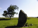

<< Our Photo Pages >> Menhir de La Varnette - Standing Stone (Menhir) in Switzerland in Waadt
Submitted by wirzroland on Friday, 05 March 2021 Page Views: 522
Neolithic and Bronze AgeSite Name: Menhir de La VarnetteCountry: Switzerland
NOTE: This site is 3.129 km away from the location you searched for.
Canton: Waadt Type: Standing Stone (Menhir)
Nearest Town: Yverdon-les-Bains Nearest Village: Concise
Latitude: 46.503580N Longitude: 6.388290E
Condition:
| 5 | Perfect |
| 4 | Almost Perfect |
| 3 | Reasonable but with some damage |
| 2 | Ruined but still recognisable as an ancient site |
| 1 | Pretty much destroyed, possibly visible as crop marks |
| 0 | No data. |
| -1 | Completely destroyed |
| 5 | Superb |
| 4 | Good |
| 3 | Ordinary |
| 2 | Not Good |
| 1 | Awful |
| 0 | No data. |
| 5 | Can be driven to, probably with disabled access |
| 4 | Short walk on a footpath |
| 3 | Requiring a bit more of a walk |
| 2 | A long walk |
| 1 | In the middle of nowhere, a nightmare to find |
| 0 | No data. |
| 5 | co-ordinates taken by GPS or official recorded co-ordinates |
| 4 | co-ordinates scaled from a detailed map |
| 3 | co-ordinates scaled from a bad map |
| 2 | co-ordinates of the nearest village |
| 1 | co-ordinates of the nearest town |
| 0 | no data |
Internal Links:
External Links:
")
You may be viewing yesterday's version of this page. To see the most up to date information please register for a free account.
")
")
")
")
Do not use the above information on other web sites or publications without permission of the contributor.
Nearby Images from Flickr
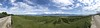
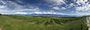
The above images may not be of the site on this page, but were taken nearby. They are loaded from Flickr so please click on them for image credits.
Click here to see more info for this site
Nearby sites
Click here to view sites on an interactive map of the areaKey: Red: member's photo, Blue: 3rd party photo, Yellow: other image, Green: no photo - please go there and take one, Grey: site destroyed
Download sites to:
KML (Google Earth)
GPX (GPS waypoints)
CSV (Garmin/Navman)
CSV (Excel)
To unlock full downloads you need to sign up as a Contributory Member. Otherwise downloads are limited to 50 sites.
Turn off the page maps and other distractions
Nearby sites listing. In the following links * = Image available
1m E 90° Erratic Stone Corcelles-Cormondrèche* Natural Stone / Erratic / Other Natural Feature
5.4km W 281° Pierre à écuelles d'Outard Rock Art
5.4km WNW 282° Pierre du Bois Cabrol Rock Art
10.2km WSW 247° Pierre à Phébon Rock Art
10.2km WSW 248° Pierre à Roland Rock Art
10.2km WSW 249° Pierre à Schacrau Rock Art
16.0km N 7° Mont-la-Ville Schalenstein Rock Art
16.2km S 171° Pierre des Sacrifices (Anthy sur Leman)* Rock Art
16.9km WSW 240° Givrins Menhir* Standing Stone (Menhir)
17.5km N 11° La Praz Steinkreis* Stone Circle
18.6km SSW 203° Pierre a Cupules (Messery) Rock Art
18.9km E 83° Musee cantonal de Lausanne* Museum
19.0km S 182° Musée de la Préhistoire (Sciez)* Museum
19.2km NNE 20° Pierre à Camille* Modern Stone Circle etc
19.4km S 183° Pierre a Cupules (Sciez) Rock Art
19.5km SSE 163° Musée Archéologique (Allinges) Museum
21.0km SSE 159° La Pierre du Diable (Allinges) Rock Art
22.7km E 90° Lutry Menhirs* Stone Circle
26.6km S 183° Dolmen de Bons-en-Chablais Burial Chamber or Dolmen
28.2km SW 230° Menhir du Mont-Mourex Standing Stone (Menhir)
29.7km SW 222° Chavannes-des-Bois Menhir* Standing Stone (Menhir)
30.2km WNW 302° Menhir de La Chevrerie Standing Stone (Menhir)
30.2km NNE 16° Pierre du Bon Château Rock Art
30.7km NNE 21° Rances Schalensteine Rock Art
32.1km ENE 75° Pierre du dos á l'âne* Standing Stone (Menhir)
View more nearby sites and additional images


 We would like to know more about this location. Please feel free to add a brief description and any relevant information in your own language.
 Wir möchten mehr über diese Stätte erfahren. Bitte zögern Sie nicht, eine kurze Beschreibung und relevante Informationen in Deutsch hinzuzufügen.
 Nous aimerions en savoir encore un peu sur les lieux. S'il vous plaît n'hesitez pas à ajouter une courte description et tous les renseignements pertinents dans votre propre langue.
 Quisieramos informarnos un poco más de las lugares. No dude en añadir una breve descripción y otros datos relevantes en su propio idioma.