
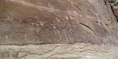

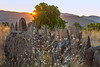
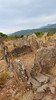
<< Our Photo Pages >> Gaoutabry Dolmen - Burial Chamber or Dolmen in France in Provence:Var (83)
Submitted by AlexHunger on Tuesday, 17 May 2005 Page Views: 3232
Neolithic and Bronze AgeSite Name: Gaoutabry Dolmen Alternative Name: Dolmen de Gauttobry, GotteaubryCountry: France
NOTE: This site is 3.771 km away from the location you searched for.
Département: Provence:Var (83) Type: Burial Chamber or Dolmen
Nearest Town: Toulon Nearest Village: La Londe-Les-Maures
Latitude: 43.171818N Longitude: 6.238809E
Condition:
| 5 | Perfect |
| 4 | Almost Perfect |
| 3 | Reasonable but with some damage |
| 2 | Ruined but still recognisable as an ancient site |
| 1 | Pretty much destroyed, possibly visible as crop marks |
| 0 | No data. |
| -1 | Completely destroyed |
| 5 | Superb |
| 4 | Good |
| 3 | Ordinary |
| 2 | Not Good |
| 1 | Awful |
| 0 | No data. |
| 5 | Can be driven to, probably with disabled access |
| 4 | Short walk on a footpath |
| 3 | Requiring a bit more of a walk |
| 2 | A long walk |
| 1 | In the middle of nowhere, a nightmare to find |
| 0 | No data. |
| 5 | co-ordinates taken by GPS or official recorded co-ordinates |
| 4 | co-ordinates scaled from a detailed map |
| 3 | co-ordinates scaled from a bad map |
| 2 | co-ordinates of the nearest village |
| 1 | co-ordinates of the nearest town |
| 0 | no data |
Internal Links:
External Links:
I have visited· I would like to visit
J_W_R visited on 1st Jan 2019 - their rating: Cond: 3 Amb: 4 Access: 3
")
More of an allee couverte, but no capstones. Dirt road 2.3 Km North of town
You may be viewing yesterday's version of this page. To see the most up to date information please register for a free account.
")
")
")
")
Do not use the above information on other web sites or publications without permission of the contributor.
Nearby Images from Flickr


The above images may not be of the site on this page, but were taken nearby. They are loaded from Flickr so please click on them for image credits.
Click here to see more info for this site
Nearby sites
Click here to view sites on an interactive map of the areaKey: Red: member's photo, Blue: 3rd party photo, Yellow: other image, Green: no photo - please go there and take one, Grey: site destroyed
Download sites to:
KML (Google Earth)
GPX (GPS waypoints)
CSV (Garmin/Navman)
CSV (Excel)
To unlock full downloads you need to sign up as a Contributory Member. Otherwise downloads are limited to 50 sites.
Turn off the page maps and other distractions
Nearby sites listing. In the following links * = Image available
6.2km NE 45° Menhir de St-Guillaume Standing Stone (Menhir)
7.1km NE 55° Menhir de Babaou Standing Stone (Menhir)
9.4km ENE 58° Deux menhirs de la Ferme Lambert* Standing Stone (Menhir)
10.9km E 98° Pierre D'Avenon Standing Stone (Menhir)
11.4km W 275° Dolmen de Maubelle Burial Chamber or Dolmen
12.8km WNW 297° Dolmen des Antiquailles Burial Chamber or Dolmen
15.5km N 357° Haute Suane dolmen Burial Chamber or Dolmen
16.0km WNW 293° Camp dit Castellas de Cuers Hillfort
16.7km NNE 12° La Roquette Grotte Sepulcrale Cave or Rock Shelter
17.3km NW 320° Grotte de Themere Cave or Rock Shelter
17.4km NNE 13° Grotte Sepulcrale des Perles Cave or Rock Shelter
17.4km WNW 287° Oppidum de Castellas (Solliès-Toucas) Ancient Village or Settlement
17.8km WNW 282° Dolmen des Avellanies Burial Chamber or Dolmen
18.1km WNW 288° La Guiranne Oppidium Hillfort
18.2km WNW 304° Grotte Sepulcrale du Tisserand Cave or Rock Shelter
19.0km W 270° Le Coudon Grotte Sepulcrale Cave or Rock Shelter
19.3km WNW 282° Baume de Truebi Grotte Sepulcrale Cave or Rock Shelter
22.2km NNW 331° Grotte des Oustaous Routs Cave or Rock Shelter
22.6km E 82° Montjean Oppidium Hillfort
23.4km W 268° Grande Grotte Sepulcrale de la Ripelle Cave or Rock Shelter
23.7km W 269° Petite Grotte Sepulcrale de la Ripelle Cave or Rock Shelter
24.1km W 262° Tour de l'Uba Grotte Sepulcrale Cave or Rock Shelter
24.3km NE 47° Baumes des Maures Grotte Sepulcrale Cave or Rock Shelter
26.1km N 356° Dolmen de Candumy Burial Chamber or Dolmen
26.2km ENE 62° Les Lions Dolmen Burial Chamber or Dolmen
View more nearby sites and additional images


 We would like to know more about this location. Please feel free to add a brief description and any relevant information in your own language.
 Wir möchten mehr über diese Stätte erfahren. Bitte zögern Sie nicht, eine kurze Beschreibung und relevante Informationen in Deutsch hinzuzufügen.
 Nous aimerions en savoir encore un peu sur les lieux. S'il vous plaît n'hesitez pas à ajouter une courte description et tous les renseignements pertinents dans votre propre langue.
 Quisieramos informarnos un poco más de las lugares. No dude en añadir una breve descripción y otros datos relevantes en su propio idioma.