

<< Our Photo Pages >> The oldest settlement Aynikab - Ancient Village or Settlement in Russia
Submitted by AlexAssa on Wednesday, 30 December 2015 Page Views: 2149
Multi-periodSite Name: The oldest settlement Aynikab Alternative Name: Айникаб стоянкаCountry: Russia
NOTE: This site is 80.391 km away from the location you searched for.
Type: Ancient Village or Settlement
Nearest Town: Makhachkala Nearest Village: Aynikab
Latitude: 42.369219N Longitude: 47.217497E
Condition:
| 5 | Perfect |
| 4 | Almost Perfect |
| 3 | Reasonable but with some damage |
| 2 | Ruined but still recognisable as an ancient site |
| 1 | Pretty much destroyed, possibly visible as crop marks |
| 0 | No data. |
| -1 | Completely destroyed |
| 5 | Superb |
| 4 | Good |
| 3 | Ordinary |
| 2 | Not Good |
| 1 | Awful |
| 0 | No data. |
| 5 | Can be driven to, probably with disabled access |
| 4 | Short walk on a footpath |
| 3 | Requiring a bit more of a walk |
| 2 | A long walk |
| 1 | In the middle of nowhere, a nightmare to find |
| 0 | No data. |
| 5 | co-ordinates taken by GPS or official recorded co-ordinates |
| 4 | co-ordinates scaled from a detailed map |
| 3 | co-ordinates scaled from a bad map |
| 2 | co-ordinates of the nearest village |
| 1 | co-ordinates of the nearest town |
| 0 | no data |
Internal Links:
External Links:
")
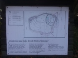
Aynikab ancient sites - The oldest settlement - a sensational discovery in Dagestan
The oldest settlement is located near the village Aynikab in Akushinsky district of Dagestan.
Age of parking based on research findings about at least 2 million years ...
This park is part of a chain of similar settlements in the area.
Archaeologists have not yet attributed to any settlement culture.
http://megalithica.ru/drevnejshaya-stoyanka-ajnikab.html
Note: Additional Info: Institute of Archaeology RAS.
You may be viewing yesterday's version of this page. To see the most up to date information please register for a free account.
")
")
Do not use the above information on other web sites or publications without permission of the contributor.
Click here to see more info for this site
Nearby sites
Click here to view sites on an interactive map of the areaKey: Red: member's photo, Blue: 3rd party photo, Yellow: other image, Green: no photo - please go there and take one, Grey: site destroyed
Download sites to:
KML (Google Earth)
GPX (GPS waypoints)
CSV (Garmin/Navman)
CSV (Excel)
To unlock full downloads you need to sign up as a Contributory Member. Otherwise downloads are limited to 50 sites.
Turn off the page maps and other distractions
Nearby sites listing. In the following links * = Image available
118.7km WSW 238° Ananauri 3 Great Kurgan* Round Barrow(s)
187.9km WNW 294° Dattykh hillfort* Hillfort
202.0km SW 227° Yastytepe Ancient Village or Settlement
210.5km SW 215° Tatarly Stone Age settlement Ancient Village or Settlement
226.3km WSW 242° Gadachrili Gora* Ancient Village or Settlement
228.5km SE 133° Besh Barmak Compass Stone* Rock Art
229.4km SE 133° Besh Barmak Snake Figure* Hill Figure or Geoglyph
231.7km SE 133° Besh Barmak* Natural Stone / Erratic / Other Natural Feature
244.1km SW 229° Anapat Cave Rock Art
254.4km SSE 163° Whale Rock* Natural Stone / Erratic / Other Natural Feature
265.8km WSW 249° Mamulos Pantiani* Ancient Village or Settlement
269.2km WSW 255° Tejisi Menhir* Standing Stone (Menhir)
272.7km SE 140° Bosdag Hill* Ancient Village or Settlement
272.7km SE 140° Bosdag* Natural Stone / Erratic / Other Natural Feature
272.7km SE 140° Bosdag passageway* Rock Art
274.2km SE 139° Dragon Ditch* Misc. Earthwork
276.7km SW 220° Berdunk Urartian Fortress Promontory Fort / Cliff Castle
279.1km SE 142° Camel Hill* Natural Stone / Erratic / Other Natural Feature
280.4km SW 223° Lchashen Bronze-Age complex Ancient Village or Settlement
284.8km SE 141° Bosdag Chambered Cairn* Chambered Cairn
285.4km SSW 211° Inscription of Tsovinar Rock Art
285.4km SSW 211° Odzaberd Promontory Fort / Cliff Castle
286.2km SW 216° K'anaker* Stone Circle
289.1km SSW 210° Khrber Ancient Village or Settlement
291.6km WSW 252° Chikiani Menhir Standing Stone (Menhir)
View more nearby sites and additional images


 We would like to know more about this location. Please feel free to add a brief description and any relevant information in your own language.
 Wir möchten mehr über diese Stätte erfahren. Bitte zögern Sie nicht, eine kurze Beschreibung und relevante Informationen in Deutsch hinzuzufügen.
 Nous aimerions en savoir encore un peu sur les lieux. S'il vous plaît n'hesitez pas à ajouter une courte description et tous les renseignements pertinents dans votre propre langue.
 Quisieramos informarnos un poco más de las lugares. No dude en añadir una breve descripción y otros datos relevantes en su propio idioma.