

<< Our Photo Pages >> Girsu - Ancient Village or Settlement in Iraq
Submitted by AlexHunger on Saturday, 04 November 2006 Page Views: 7918
Multi-periodSite Name: Girsu Alternative Name: NgirsuCountry: Iraq
NOTE: This site is 6.675 km away from the location you searched for.
Type: Ancient Village or Settlement
Nearest Town: Nasiriyah Nearest Village: Tello
Latitude: 31.561540N Longitude: 46.177890E
Condition:
| 5 | Perfect |
| 4 | Almost Perfect |
| 3 | Reasonable but with some damage |
| 2 | Ruined but still recognisable as an ancient site |
| 1 | Pretty much destroyed, possibly visible as crop marks |
| 0 | No data. |
| -1 | Completely destroyed |
| 5 | Superb |
| 4 | Good |
| 3 | Ordinary |
| 2 | Not Good |
| 1 | Awful |
| 0 | No data. |
| 5 | Can be driven to, probably with disabled access |
| 4 | Short walk on a footpath |
| 3 | Requiring a bit more of a walk |
| 2 | A long walk |
| 1 | In the middle of nowhere, a nightmare to find |
| 0 | No data. |
| 5 | co-ordinates taken by GPS or official recorded co-ordinates |
| 4 | co-ordinates scaled from a detailed map |
| 3 | co-ordinates scaled from a bad map |
| 2 | co-ordinates of the nearest village |
| 1 | co-ordinates of the nearest town |
| 0 | no data |
Internal Links:
External Links:
")
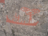
Ancient Sumerian, Akkadian, Babylonian town. At the time of king Gudea, the kingdom ruled 17 bigger towns, eight district capitals, and numerous villages of which about 40 are known by name. The objects found at Telloh are some of the most valuable Babylonian art treasures.
You may be viewing yesterday's version of this page. To see the most up to date information please register for a free account.
")
")
")
")
")
")
")
Do not use the above information on other web sites or publications without permission of the contributor.
Click here to see more info for this site
Nearby sites
Click here to view sites on an interactive map of the areaKey: Red: member's photo, Blue: 3rd party photo, Yellow: other image, Green: no photo - please go there and take one, Grey: site destroyed
Download sites to:
KML (Google Earth)
GPX (GPS waypoints)
CSV (Garmin/Navman)
CSV (Excel)
To unlock full downloads you need to sign up as a Contributory Member. Otherwise downloads are limited to 50 sites.
Turn off the page maps and other distractions
Nearby sites listing. In the following links * = Image available
30.5km WNW 285° Umma Ancient Village or Settlement
35.1km WNW 303° Zabalam Ancient Village or Settlement
36.6km ESE 113° Lagash* Ancient Village or Settlement
47.6km NNW 335° Adab* Ancient Village or Settlement
48.0km SW 221° Larsa Ancient Village or Settlement
58.2km WSW 242° Uruk.* Ancient Village or Settlement
62.5km S 178° Tell Khaiber* Ancient Village or Settlement
67.0km S 186° Ur of the Chaldees* Ancient Village or Settlement
76.7km WNW 293° Kisurra Ancient Village or Settlement
82.3km S 170° Kisiga Ancient Village or Settlement
84.8km SSW 192° Eridu* Ancient Village or Settlement
94.2km WNW 296° Isin Ancient Village or Settlement
108.8km WNW 281° Shuruppak* Ancient Village or Settlement
115.5km NW 306° Nippur* Ancient Village or Settlement
143.2km WNW 293° Marad Ancient Village or Settlement
171.5km WNW 293° Dilbat Ancient Village or Settlement
181.1km NW 308° Kish Ancient Village or Settlement
192.9km NW 313° Kutha Ancient Village or Settlement
196.3km WNW 299° Borsippa* Ancient Village or Settlement
202.1km WNW 303° Babylon.* Ancient Village or Settlement
207.8km ENE 70° Susa (Iran)* Ancient Palace
211.3km ENE 74° Haft Tepe* Ancient Temple
227.1km ENE 77° Chogha Zanbil* Ancient Temple
236.3km ENE 71° Chogha Mish* Ancient Village or Settlement
245.9km NW 313° Sippar* Ancient Village or Settlement
View more nearby sites and additional images


 We would like to know more about this location. Please feel free to add a brief description and any relevant information in your own language.
 Wir möchten mehr über diese Stätte erfahren. Bitte zögern Sie nicht, eine kurze Beschreibung und relevante Informationen in Deutsch hinzuzufügen.
 Nous aimerions en savoir encore un peu sur les lieux. S'il vous plaît n'hesitez pas à ajouter une courte description et tous les renseignements pertinents dans votre propre langue.
 Quisieramos informarnos un poco más de las lugares. No dude en añadir una breve descripción y otros datos relevantes en su propio idioma.