


<< Our Photo Pages >> La Haute Borne de Fontaines-sur-Marne - Standing Stone (Menhir) in France in Champagne:Haute-Marne (52)
Submitted by AlexHunger on Tuesday, 17 May 2005 Page Views: 6369
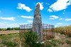
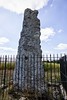
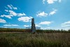
Neolithic and Bronze AgeSite Name: La Haute Borne de Fontaines-sur-MarneCountry: France Département: Champagne:Haute-Marne (52) Type: Standing Stone (Menhir)
Nearest Town: Saint-Dizier Nearest Village: Fontaines-sur-Marne
Latitude: 48.550214N Longitude: 5.115301E
Condition:
| 5 | Perfect |
| 4 | Almost Perfect |
| 3 | Reasonable but with some damage |
| 2 | Ruined but still recognisable as an ancient site |
| 1 | Pretty much destroyed, possibly visible as crop marks |
| 0 | No data. |
| -1 | Completely destroyed |
| 5 | Superb |
| 4 | Good |
| 3 | Ordinary |
| 2 | Not Good |
| 1 | Awful |
| 0 | No data. |
| 5 | Can be driven to, probably with disabled access |
| 4 | Short walk on a footpath |
| 3 | Requiring a bit more of a walk |
| 2 | A long walk |
| 1 | In the middle of nowhere, a nightmare to find |
| 0 | No data. |
| 5 | co-ordinates taken by GPS or official recorded co-ordinates |
| 4 | co-ordinates scaled from a detailed map |
| 3 | co-ordinates scaled from a bad map |
| 2 | co-ordinates of the nearest village |
| 1 | co-ordinates of the nearest town |
| 0 | no data |
Internal Links:
External Links:
")
About 3 meters tall Menhir surounded by fence
Location Source: T4T35
Wikipedia article
Sites mégalithiques de la Haute-Marne
You may be viewing yesterday's version of this page. To see the most up to date information please register for a free account.
")
Do not use the above information on other web sites or publications without permission of the contributor.
Nearby Images from Flickr
The above images may not be of the site on this page, but were taken nearby. They are loaded from Flickr so please click on them for image credits.
Click here to see more info for this site
Nearby sites
Click here to view sites on an interactive map of the areaKey: Red: member's photo, Blue: 3rd party photo, Yellow: other image, Green: no photo - please go there and take one, Grey: site destroyed
Download sites to:
KML (Google Earth)
GPX (GPS waypoints)
CSV (Garmin/Navman)
CSV (Excel)
To unlock full downloads you need to sign up as a Contributory Member. Otherwise downloads are limited to 50 sites.
Turn off the page maps and other distractions
Nearby sites listing. In the following links * = Image available
15.5km NNE 12° Menhir le Corrois Standing Stone (Menhir)
15.6km NNE 17° Allée Couverte du Ruissard Passage Grave
15.8km NNE 23° Menhir de Champ l'Ecuyer Standing Stone (Menhir)
17.0km NNE 24° Menhir de la Chèvre Standing Stone (Menhir)
18.6km NNE 14° Champ l'Alouette Menhir Standing Stone (Menhir)
23.9km ENE 65° Oppidum des Leuci* Ancient Village or Settlement
33.2km ESE 123° Andesina* Ancient Temple
33.4km NNE 21° Rumont burial chamber Burial Chamber or Dolmen
36.2km SSE 163° Dolmen dit la Pierre qui Tourne Burial Chamber or Dolmen
36.3km SSE 164° Coffres de Fort Bévaux (Septfontaines) Barrow Cemetery
37.1km SSE 168° Dolmen du Bois de la Grande-Bay Burial Chamber or Dolmen
40.1km ESE 110° Dolmen du Bois du Comtot Burial Chamber or Dolmen
41.9km NE 47° Le Menhir des 3 évêchés* Standing Stone (Menhir)
42.5km NE 44° La Pierre Trouée * Standing Stone (Menhir)
47.8km NE 40° Le Camp des Romains Ancient Village or Settlement
48.2km SSE 157° Menhir dit la Pierre Bernard Standing Stone (Menhir)
48.8km NE 38° La Grosse Borne (Chauvoncourt)* Standing Stone (Menhir)
49.2km NE 39° La Cote-de-Bar Cave or Rock Shelter
50.8km ESE 119° Grotte de L´Enfer et de Jeannuë Cave or Rock Shelter
52.5km ESE 120° Vielles-Roches Barrow Cemetery
54.2km NE 43° La Dame Schone Menhir* Standing Stone (Menhir)
55.5km NE 46° Woinville Menhir* Standing Stone (Menhir)
57.5km SE 125° Beaufremont-St-Charles necropolis Barrow Cemetery
57.7km SE 126° Coffre du Bois-Saint-Charles Burial Chamber or Dolmen
57.9km NW 321° La Garenne Tumulus Chambered Cairn
View more nearby sites and additional images


 We would like to know more about this location. Please feel free to add a brief description and any relevant information in your own language.
 Wir möchten mehr über diese Stätte erfahren. Bitte zögern Sie nicht, eine kurze Beschreibung und relevante Informationen in Deutsch hinzuzufügen.
 Nous aimerions en savoir encore un peu sur les lieux. S'il vous plaît n'hesitez pas à ajouter une courte description et tous les renseignements pertinents dans votre propre langue.
 Quisieramos informarnos un poco más de las lugares. No dude en añadir una breve descripción y otros datos relevantes en su propio idioma.