 with our Megalithic Portal iPhone app")

<< Our Photo Pages >> Dolmen field near Natur on the Golan Heights - Barrow Cemetery in Israel
Submitted by motist on Thursday, 12 October 2017 Page Views: 1483
Neolithic and Bronze AgeSite Name: Dolmen field near Natur on the Golan HeightsCountry: Israel
NOTE: This site is 16.097 km away from the location you searched for.
Type: Barrow Cemetery
Nearest Town: Qatsrin Nearest Village: Natur
Latitude: 32.886416N Longitude: 35.803188E
Condition:
| 5 | Perfect |
| 4 | Almost Perfect |
| 3 | Reasonable but with some damage |
| 2 | Ruined but still recognisable as an ancient site |
| 1 | Pretty much destroyed, possibly visible as crop marks |
| 0 | No data. |
| -1 | Completely destroyed |
| 5 | Superb |
| 4 | Good |
| 3 | Ordinary |
| 2 | Not Good |
| 1 | Awful |
| 0 | No data. |
| 5 | Can be driven to, probably with disabled access |
| 4 | Short walk on a footpath |
| 3 | Requiring a bit more of a walk |
| 2 | A long walk |
| 1 | In the middle of nowhere, a nightmare to find |
| 0 | No data. |
| 5 | co-ordinates taken by GPS or official recorded co-ordinates |
| 4 | co-ordinates scaled from a detailed map |
| 3 | co-ordinates scaled from a bad map |
| 2 | co-ordinates of the nearest village |
| 1 | co-ordinates of the nearest town |
| 0 | no data |
Internal Links:
External Links:
")
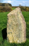
On a visit to the Golan Heights in Israel, my wife and I ran into a fenced area, with a lot of stone heaps. It's a cattle area, so we had to go through a wired fence. When we came closer we realized it's a huge dolmen field, with Iron age cattle pens. I took some pictures as evidence.
You may be viewing yesterday's version of this page. To see the most up to date information please register for a free account.
")
")
")
")
")
")
")
")
")
")
")
")
")
")
")
")
")
")
")
")
")
")
")
")
These are just the first 25 photos of Dolmen field near Natur on the Golan Heights. If you log in with a free user account you will be able to see our entire collection.
Do not use the above information on other web sites or publications without permission of the contributor.
Click here to see more info for this site
Nearby sites
Click here to view sites on an interactive map of the areaKey: Red: member's photo, Blue: 3rd party photo, Yellow: other image, Green: no photo - please go there and take one, Grey: site destroyed
Download sites to:
KML (Google Earth)
GPX (GPS waypoints)
CSV (Garmin/Navman)
CSV (Excel)
To unlock full downloads you need to sign up as a Contributory Member. Otherwise downloads are limited to 50 sites.
Turn off the page maps and other distractions
Nearby sites listing. In the following links * = Image available
2.5km N 355° Rujm el-Hiri* Stone Circle
5.5km WNW 294° Gamla Dolmen field* Burial Chamber or Dolmen
5.7km WNW 292° The ancient city of Gamla* Ancient Village or Settlement
15.8km WSW 245° Kursi National Park* Ancient Village or Settlement
16.4km W 279° Bethsaida* Ancient Village or Settlement
17.0km NNE 19° Dubbah Breika Ancient Village or Settlement
17.3km SW 229° NEG II Prehistoric Village* Ancient Village or Settlement
17.3km SW 229° Wadi Ein Gev Ancient Village or Settlement
18.0km SW 228° Sussita* Ancient Village or Settlement
26.3km WNW 304° Tel Hatzor* Artificial Mound
27.1km WSW 240° Hammat Tiberias* Ancient Village or Settlement
27.9km W 259° Dalmanutha* Ancient Village or Settlement
27.9km SW 228° Sea of Galilee Cairn* Cairn
28.7km SW 228° Tel Bet Yerah Artificial Mound
28.8km SW 229° Ohalo II* Ancient Village or Settlement
29.4km SW 220° Sha'ar HaGolan* Ancient Village or Settlement
30.2km W 270° Hukok* Ancient Temple
30.4km WNW 295° Naburiya synagogue in Biriya Forest* Ancient Temple
33.4km NNW 337° Engraved dolmen near Kibbutz Shamir* Burial Chamber or Dolmen
35.6km W 280° Crescent-shaped monument near Shefer* Artificial Mound
35.8km S 180° Rasun (Jordan)* Burial Chamber or Dolmen
36.0km NW 315° Tel Kadesh Naftali* Ancient Village or Settlement
36.5km S 173° Irbid* Ancient Village or Settlement
36.8km N 354° Dolmen field in Odem forest on The Golan Heights* Artificial Mound
40.3km WNW 296° Baram Synagogue* Ancient Temple
View more nearby sites and additional images


 We would like to know more about this location. Please feel free to add a brief description and any relevant information in your own language.
 Wir möchten mehr über diese Stätte erfahren. Bitte zögern Sie nicht, eine kurze Beschreibung und relevante Informationen in Deutsch hinzuzufügen.
 Nous aimerions en savoir encore un peu sur les lieux. S'il vous plaît n'hesitez pas à ajouter une courte description et tous les renseignements pertinents dans votre propre langue.
 Quisieramos informarnos un poco más de las lugares. No dude en añadir una breve descripción y otros datos relevantes en su propio idioma.