


<< Image Pages >> Hesbon - Burial Chamber or Dolmen in Jordan
Submitted by enkidu41 on Thursday, 20 January 2005 Page Views: 9857
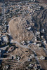
Neolithic and Bronze AgeSite Name: Hesbon Alternative Name: Heshbon, al KurmiyehCountry: Jordan
NOTE: This site is 5.263 km away from the location you searched for.
Type: Burial Chamber or Dolmen
Nearest Town: Hesbon Nearest Village: Hesbon
Latitude: 31.818611N Longitude: 35.798889E
Condition:
| 5 | Perfect |
| 4 | Almost Perfect |
| 3 | Reasonable but with some damage |
| 2 | Ruined but still recognisable as an ancient site |
| 1 | Pretty much destroyed, possibly visible as crop marks |
| 0 | No data. |
| -1 | Completely destroyed |
| 5 | Superb |
| 4 | Good |
| 3 | Ordinary |
| 2 | Not Good |
| 1 | Awful |
| 0 | No data. |
| 5 | Can be driven to, probably with disabled access |
| 4 | Short walk on a footpath |
| 3 | Requiring a bit more of a walk |
| 2 | A long walk |
| 1 | In the middle of nowhere, a nightmare to find |
| 0 | No data. |
| 5 | co-ordinates taken by GPS or official recorded co-ordinates |
| 4 | co-ordinates scaled from a detailed map |
| 3 | co-ordinates scaled from a bad map |
| 2 | co-ordinates of the nearest village |
| 1 | co-ordinates of the nearest town |
| 0 | no data |
Be the first person to rate this site - see the 'Contribute!' box in the right hand menu.
Internal Links:
External Links:
")
There is a cairn on top of the al Kurmiyeh hill, a circle and double circles of smaller unhewn stones, some small menhirs and a good number of round holes (cup-hollows) 1 to 2 feet in diameter. There are also two rock-cut chambers and a possible wine press comprising a square basin, about 20 cm deep, with a connecting channel to a second, lower and smaller basin.
Note: With acknowledgements to H. G. Scheltema 2004
You may be viewing yesterday's version of this page. To see the most up to date information please register for a free account.
More pictures in our eGallery: Hesbon
")
Do not use the above information on other web sites or publications without permission of the contributor.
Nearby Images from Flickr
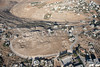
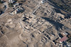
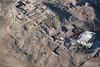
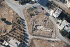

The above images may not be of the site on this page, but were taken nearby. They are loaded from Flickr so please click on them for image credits.
Click here to see more info for this site
Nearby sites
Click here to view sites on an interactive map of the areaKey: Red: member's photo, Blue: 3rd party photo, Yellow: other image, Green: no photo - please go there and take one, Grey: site destroyed
Download sites to:
KML (Google Earth)
GPX (GPS waypoints)
CSV (Garmin/Navman)
CSV (Excel)
To unlock full downloads you need to sign up as a Contributory Member. Otherwise downloads are limited to 50 sites.
Turn off the page maps and other distractions
Nearby sites listing. In the following links * = Image available
10.1km ENE 56° Tall al-Umayri* Ancient Village or Settlement
10.9km W 277° Rawdah* Burial Chamber or Dolmen
11.0km S 184° Adeihmeh* Burial Chamber or Dolmen
11.2km S 182° Madaba Mosaic Map* Misc. Earthwork
11.4km S 182° Madaba (Jordan)* Ancient Village or Settlement
12.3km SW 217° Dolmens at Wadi Jadid* Burial Chamber or Dolmen
18.6km NE 38° Amman.* NOT SET
18.9km W 265° Tulaylat al-Ghassul Ancient Village or Settlement
19.8km NE 40° Jordan Archaeological Museum* Museum
19.8km NE 40° Amman Citadel* Ancient Village or Settlement
20.5km SSW 207° Khajar Mansub* Standing Stone (Menhir)
20.7km SSW 207° el-Mareighat* Burial Chamber or Dolmen
20.7km SSW 207° South of Khajar Mansub Menhirs & Dolmens* Chambered Tomb
25.2km NE 42° Ain Ghazal* Ancient Village or Settlement
27.5km SSE 158° Khirbat Al-Mudayna* Ancient Village or Settlement
32.2km WNW 283° The Gilgal associated peacefully with Joshua Stone Circle
32.5km SSW 211° Mukawir* Hillfort
33.2km WSW 255° Qumran* Ancient Village or Settlement
34.5km W 276° Jericho* Ancient Village or Settlement
35.8km S 183° Khirbet Ataruz Ancient Village or Settlement
37.2km SSE 162° Umm Al-Rasas* Ancient Village or Settlement
38.0km NW 324° Damiyah dolmen field* Burial Chamber or Dolmen
46.7km NW 325° Argaman-Gilgal sanctuary Ancient Temple
48.8km S 188° Redjom el A'abed* Ancient Village or Settlement
52.0km N 10° Jerash* Ancient Village or Settlement
View more nearby sites and additional images


 We would like to know more about this location. Please feel free to add a brief description and any relevant information in your own language.
 Wir möchten mehr über diese Stätte erfahren. Bitte zögern Sie nicht, eine kurze Beschreibung und relevante Informationen in Deutsch hinzuzufügen.
 Nous aimerions en savoir encore un peu sur les lieux. S'il vous plaît n'hesitez pas à ajouter une courte description et tous les renseignements pertinents dans votre propre langue.
 Quisieramos informarnos un poco más de las lugares. No dude en añadir una breve descripción y otros datos relevantes en su propio idioma.