


<< Our Photo Pages >> Sarikaya Roman Bath - Ancient Village or Settlement in Turkey
Submitted by davidmorgan on Monday, 07 August 2023 Page Views: 710
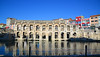
Roman, Greek and ClassicalSite Name: Sarikaya Roman Bath Alternative Name: Aqua Sarvenae, The King’s Daughter, Kral Kızı Hamamı, Sarıkaya Roma HamamıCountry: Turkey
NOTE: This site is 6.793 km away from the location you searched for.
Type: Ancient Village or Settlement
Nearest Town: Sarıkaya
Latitude: 39.494998N Longitude: 35.376371E
Condition:
| 5 | Perfect |
| 4 | Almost Perfect |
| 3 | Reasonable but with some damage |
| 2 | Ruined but still recognisable as an ancient site |
| 1 | Pretty much destroyed, possibly visible as crop marks |
| 0 | No data. |
| -1 | Completely destroyed |
| 5 | Superb |
| 4 | Good |
| 3 | Ordinary |
| 2 | Not Good |
| 1 | Awful |
| 0 | No data. |
| 5 | Can be driven to, probably with disabled access |
| 4 | Short walk on a footpath |
| 3 | Requiring a bit more of a walk |
| 2 | A long walk |
| 1 | In the middle of nowhere, a nightmare to find |
| 0 | No data. |
| 5 | co-ordinates taken by GPS or official recorded co-ordinates |
| 4 | co-ordinates scaled from a detailed map |
| 3 | co-ordinates scaled from a bad map |
| 2 | co-ordinates of the nearest village |
| 1 | co-ordinates of the nearest town |
| 0 | no data |
Internal Links:
External Links:
")
On the UNESCO World Heritage tentative list.
Note: Restoration of this extraordinary Roman bath nears completion, more on our page
You may be viewing yesterday's version of this page. To see the most up to date information please register for a free account.
Do not use the above information on other web sites or publications without permission of the contributor.
Nearby Images from Flickr


The above images may not be of the site on this page, but were taken nearby. They are loaded from Flickr so please click on them for image credits.
Click here to see more info for this site
Nearby sites
Click here to view sites on an interactive map of the areaKey: Red: member's photo, Blue: 3rd party photo, Yellow: other image, Green: no photo - please go there and take one, Grey: site destroyed
Download sites to:
KML (Google Earth)
GPX (GPS waypoints)
CSV (Garmin/Navman)
CSV (Excel)
To unlock full downloads you need to sign up as a Contributory Member. Otherwise downloads are limited to 50 sites.
Turn off the page maps and other distractions
Nearby sites listing. In the following links * = Image available
15.8km NW 321° Alisar Hoyuk* Ancient Village or Settlement
28.4km NW 315° Cadir Hoyuk* Ancient Village or Settlement
34.8km N 357° Karakiz* Carving
39.2km NW 316° Kerkenes Ancient Village or Settlement
44.9km NW 322° Usakli Mound* Ancient Village or Settlement
61.0km NW 307° Yozgat Ethnographic Museum Museum
72.0km SW 221° Topakli Hoyuk Ancient Village or Settlement
73.0km SE 142° Sultan Hani Stele* Rock Art
74.9km SSE 162° Karum Kanes* Ancient Village or Settlement
75.0km SSE 163° Kültepe Kanes* Ancient Village or Settlement
79.0km NNW 329° Örükaya Roman Dam Ancient Mine, Quarry or other Industry
79.8km NNE 24° Masat Hoyuk Ancient Village or Settlement
85.3km N 352° Shapinuwa Ancient Village or Settlement
86.6km S 174° Kayseri Archaeological Museum* Museum
86.7km NW 313° Yazilikaya* Carving
87.4km NW 312° Hattuşa* Ancient Village or Settlement
89.4km S 188° Örenşehir* Ancient Village or Settlement
90.0km NW 325° Eskiyapar Ancient Village or Settlement
99.1km NW 325° Alacahöyük Hittite Dam* Misc. Earthwork
99.2km NNW 339° Pazarli Ancient Village or Settlement
99.7km E 82° Kayalipinar Ancient Village or Settlement
100.7km NW 325° Alacahöyük* Ancient Village or Settlement
102.5km W 268° Hashöyük Ancient Village or Settlement
103.2km SSW 206° Rock Cones of Urgup (Cappadocia)* Natural Stone / Erratic / Other Natural Feature
104.8km SW 230° Karaburna* Carving
View more nearby sites and additional images


 We would like to know more about this location. Please feel free to add a brief description and any relevant information in your own language.
 Wir möchten mehr über diese Stätte erfahren. Bitte zögern Sie nicht, eine kurze Beschreibung und relevante Informationen in Deutsch hinzuzufügen.
 Nous aimerions en savoir encore un peu sur les lieux. S'il vous plaît n'hesitez pas à ajouter une courte description et tous les renseignements pertinents dans votre propre langue.
 Quisieramos informarnos un poco más de las lugares. No dude en añadir una breve descripción y otros datos relevantes en su propio idioma.