


<< Text Pages >> Çorum Archaeological Museum - Museum in Turkey
Submitted by davidmorgan on Tuesday, 22 December 2015 Page Views: 1240
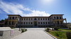
MuseumsSite Name: Çorum Archaeological MuseumCountry: Turkey
NOTE: This site is 1.021 km away from the location you searched for.
Type: Museum
Nearest Town: Çorum
Latitude: 40.541047N Longitude: 34.951226E
Condition:
| 5 | Perfect |
| 4 | Almost Perfect |
| 3 | Reasonable but with some damage |
| 2 | Ruined but still recognisable as an ancient site |
| 1 | Pretty much destroyed, possibly visible as crop marks |
| 0 | No data. |
| -1 | Completely destroyed |
| 5 | Superb |
| 4 | Good |
| 3 | Ordinary |
| 2 | Not Good |
| 1 | Awful |
| 0 | No data. |
| 5 | Can be driven to, probably with disabled access |
| 4 | Short walk on a footpath |
| 3 | Requiring a bit more of a walk |
| 2 | A long walk |
| 1 | In the middle of nowhere, a nightmare to find |
| 0 | No data. |
| 5 | co-ordinates taken by GPS or official recorded co-ordinates |
| 4 | co-ordinates scaled from a detailed map |
| 3 | co-ordinates scaled from a bad map |
| 2 | co-ordinates of the nearest village |
| 1 | co-ordinates of the nearest town |
| 0 | no data |
Internal Links:
External Links:
Museum in Çorum Province, Turkey
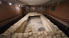
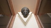
Çorum Archaeological Museum has a large collection of artefacts from the Hittite sites in the region.
You may be viewing yesterday's version of this page. To see the most up to date information please register for a free account.
Do not use the above information on other web sites or publications without permission of the contributor.
Nearby Images from Flickr


The above images may not be of the site on this page, but were taken nearby. They are loaded from Flickr so please click on them for image credits.
Click here to see more info for this site
Nearby sites
Click here to view sites on an interactive map of the areaKey: Red: member's photo, Blue: 3rd party photo, Yellow: other image, Green: no photo - please go there and take one, Grey: site destroyed
Download sites to:
KML (Google Earth)
GPX (GPS waypoints)
CSV (Garmin/Navman)
CSV (Excel)
To unlock full downloads you need to sign up as a Contributory Member. Otherwise downloads are limited to 50 sites.
Turn off the page maps and other distractions
Nearby sites listing. In the following links * = Image available
24.0km S 180° Pazarli Ancient Village or Settlement
39.9km SE 143° Shapinuwa Ancient Village or Settlement
40.4km SSW 213° Alacahöyük* Ancient Village or Settlement
40.9km SSW 210° Alacahöyük Hittite Dam* Misc. Earthwork
45.1km SSW 200° Eskiyapar Ancient Village or Settlement
48.6km S 185° Örükaya Roman Dam Ancient Mine, Quarry or other Industry
57.2km E 89° Oluz Mound* Ancient Village or Settlement
60.9km WSW 247° Boyali Hoyuk Ancient Village or Settlement
63.4km SSW 205° Yazilikaya* Carving
64.6km SSW 206° Hattuşa* Ancient Village or Settlement
74.7km E 80° Amasya Museum* Museum
80.8km S 189° Yozgat Ethnographic Museum Museum
81.4km S 174° Usakli Mound* Ancient Village or Settlement
81.4km ESE 122° Masat Hoyuk Ancient Village or Settlement
84.3km NNE 28° Oymaagac Mound Artificial Mound
88.4km S 174° Kerkenes Ancient Village or Settlement
88.5km SSE 157° Karakiz* Carving
97.5km S 170° Cadir Hoyuk* Ancient Village or Settlement
107.3km SSE 166° Alisar Hoyuk* Ancient Village or Settlement
121.8km SSE 163° Sarikaya Roman Bath* Ancient Village or Settlement
137.6km SSW 209° Hashöyük Ancient Village or Settlement
138.7km E 84° Horoztepe Ancient Village or Settlement
141.3km ESE 111° Bolus Ancient Village or Settlement
142.1km NNE 33° Ikiztepe Ancient Village or Settlement
146.9km ENE 59° Tekkekoy Caves Cave or Rock Shelter
View more nearby sites and additional images


 We would like to know more about this location. Please feel free to add a brief description and any relevant information in your own language.
 Wir möchten mehr über diese Stätte erfahren. Bitte zögern Sie nicht, eine kurze Beschreibung und relevante Informationen in Deutsch hinzuzufügen.
 Nous aimerions en savoir encore un peu sur les lieux. S'il vous plaît n'hesitez pas à ajouter une courte description et tous les renseignements pertinents dans votre propre langue.
 Quisieramos informarnos un poco más de las lugares. No dude en añadir una breve descripción y otros datos relevantes en su propio idioma.