 with our Megalithic Portal iPhone app")

<< Other Photo Pages >> Nekhen Ceremonial Enclosure of Pharao Khasekhemwy - Ancient Palace in Egypt in Upper Egypt (South)
Submitted by AlexHunger on Sunday, 27 August 2006 Page Views: 7253
Roman, Greek and ClassicalSite Name: Nekhen Ceremonial Enclosure of Pharao Khasekhemwy Alternative Name: Hierakonpolis Ceremonial Enclosure of Pharao KhaseCountry: Egypt Region: Upper Egypt (South) Type: Ancient Palace
Nearest Town: Luxor Nearest Village: Al Basaliyah Qibli
Latitude: 25.091541N Longitude: 32.773668E
Condition:
| 5 | Perfect |
| 4 | Almost Perfect |
| 3 | Reasonable but with some damage |
| 2 | Ruined but still recognisable as an ancient site |
| 1 | Pretty much destroyed, possibly visible as crop marks |
| 0 | No data. |
| -1 | Completely destroyed |
| 5 | Superb |
| 4 | Good |
| 3 | Ordinary |
| 2 | Not Good |
| 1 | Awful |
| 0 | No data. |
| 5 | Can be driven to, probably with disabled access |
| 4 | Short walk on a footpath |
| 3 | Requiring a bit more of a walk |
| 2 | A long walk |
| 1 | In the middle of nowhere, a nightmare to find |
| 0 | No data. |
| 5 | co-ordinates taken by GPS or official recorded co-ordinates |
| 4 | co-ordinates scaled from a detailed map |
| 3 | co-ordinates scaled from a bad map |
| 2 | co-ordinates of the nearest village |
| 1 | co-ordinates of the nearest town |
| 0 | no data |
Internal Links:
External Links:
")
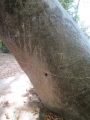
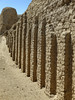
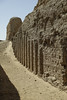
The remains of the 9 Meter tall mud brick ceremonial enclosure with granite architectural elements. In the desert, just south of the temple mound of the Dynastic site of Nekhen later called Hierakonpolis by the Greeks. The site is not accessible due to ongoing excavations.
You may be viewing yesterday's version of this page. To see the most up to date information please register for a free account.
Do not use the above information on other web sites or publications without permission of the contributor.
Nearby Images from Flickr
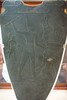
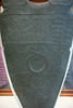

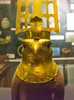
The above images may not be of the site on this page, but were taken nearby. They are loaded from Flickr so please click on them for image credits.
Click here to see more info for this site
Nearby sites
Click here to view sites on an interactive map of the areaKey: Red: member's photo, Blue: 3rd party photo, Yellow: other image, Green: no photo - please go there and take one, Grey: site destroyed
Download sites to:
KML (Google Earth)
GPX (GPS waypoints)
CSV (Garmin/Navman)
CSV (Excel)
To unlock full downloads you need to sign up as a Contributory Member. Otherwise downloads are limited to 50 sites.
Turn off the page maps and other distractions
Nearby sites listing. In the following links * = Image available
913m NE 40° Nekhen Settlement* Ancient Village or Settlement
4.0km NE 38° El Kab* Ancient Temple
5.5km NW 313° Al Kula Pyramid Pyramid / Mastaba
9.4km SE 131° Edfu Pyramid Pyramid / Mastaba
16.2km SE 142° Idfu Temple of Horus* Ancient Temple
16.2km SE 142° Idfu Mammisi* Ancient Temple
31.3km NW 316° Temple of Khnum, Esna* Ancient Temple
33.2km SSE 154° Rock Art near Qurta* Rock Art
52.2km NNW 327° Gebelein Ancient Village or Settlement
52.6km SSE 162° Gebel el-Silsila* Ancient Mine, Quarry or other Industry
59.7km NNW 336° Djerti Temple of Montu* Ancient Temple
63.3km NNW 339° Iuni Temple of Montu Ancient Temple
69.0km N 349° Temple of Luxor* Ancient Temple
69.7km N 349° Luxor Museum* Museum
69.9km NNW 344° Deir el Shelwit Ancient Temple
69.9km N 350° Luxor Temple of Mut* Ancient Temple
70.1km N 350° Luxor Avenue of Sphinxes* Carving
70.5km N 350° Karnak Temple of Osiris and Opet* Ancient Temple
70.5km N 350° Karnak Temple of Khons* Ancient Temple
70.5km N 351° Akhmenu* Ancient Temple
70.6km N 351° Karnak Sacred Lake* Holy Well or Sacred Spring
70.8km N 351° Karnak Temple of Montu* Ancient Temple
70.8km N 351° Karnak Temple of Ptah* Ancient Temple
70.8km N 350° Karnak Temple of Amun Ra* Ancient Temple
70.9km N 351° Karnak White Chapel of Senusret I* Ancient Temple
View more nearby sites and additional images


 We would like to know more about this location. Please feel free to add a brief description and any relevant information in your own language.
 Wir möchten mehr über diese Stätte erfahren. Bitte zögern Sie nicht, eine kurze Beschreibung und relevante Informationen in Deutsch hinzuzufügen.
 Nous aimerions en savoir encore un peu sur les lieux. S'il vous plaît n'hesitez pas à ajouter une courte description et tous les renseignements pertinents dans votre propre langue.
 Quisieramos informarnos un poco más de las lugares. No dude en añadir una breve descripción y otros datos relevantes en su propio idioma.