


<< Our Photo Pages >> Dendara Mammisi of Trajan - Ancient Temple in Egypt in Upper Egypt (South)
Submitted by AlexHunger on Saturday, 18 February 2006 Page Views: 3521
Roman, Greek and ClassicalSite Name: Dendara Mammisi of TrajanCountry: Egypt
NOTE: This site is 6.816 km away from the location you searched for.
Region: Upper Egypt (South) Type: Ancient Temple
Nearest Town: Dendara Nearest Village: Dendara
Latitude: 26.143020N Longitude: 32.670330E
Condition:
| 5 | Perfect |
| 4 | Almost Perfect |
| 3 | Reasonable but with some damage |
| 2 | Ruined but still recognisable as an ancient site |
| 1 | Pretty much destroyed, possibly visible as crop marks |
| 0 | No data. |
| -1 | Completely destroyed |
| 5 | Superb |
| 4 | Good |
| 3 | Ordinary |
| 2 | Not Good |
| 1 | Awful |
| 0 | No data. |
| 5 | Can be driven to, probably with disabled access |
| 4 | Short walk on a footpath |
| 3 | Requiring a bit more of a walk |
| 2 | A long walk |
| 1 | In the middle of nowhere, a nightmare to find |
| 0 | No data. |
| 5 | co-ordinates taken by GPS or official recorded co-ordinates |
| 4 | co-ordinates scaled from a detailed map |
| 3 | co-ordinates scaled from a bad map |
| 2 | co-ordinates of the nearest village |
| 1 | co-ordinates of the nearest town |
| 0 | no data |
Internal Links:
External Links:
")
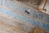
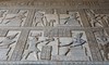
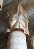
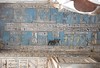
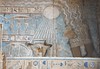
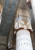
Ritual birth house of Roman Emperor Trajan to prove his divine origins. Next to Dendara Temple of Hathor. 72 Meter Altitude.
You may be viewing yesterday's version of this page. To see the most up to date information please register for a free account.
Do not use the above information on other web sites or publications without permission of the contributor.
Nearby Images from Flickr
The above images may not be of the site on this page, but were taken nearby. They are loaded from Flickr so please click on them for image credits.
Click here to see more info for this site
Nearby sites
Click here to view sites on an interactive map of the areaKey: Red: member's photo, Blue: 3rd party photo, Yellow: other image, Green: no photo - please go there and take one, Grey: site destroyed
Download sites to:
KML (Google Earth)
GPX (GPS waypoints)
CSV (Garmin/Navman)
CSV (Excel)
To unlock full downloads you need to sign up as a Contributory Member. Otherwise downloads are limited to 50 sites.
Turn off the page maps and other distractions
Nearby sites listing. In the following links * = Image available
38m SSW 210° Dendara Mammisi of Nectanabo I* Ancient Temple
146m SSW 192° Dendara Temple of Hathor* Ancient Temple
218m SSW 199° Dendara Temple of Isis* Ancient Temple
19.5km SSE 161° Pyramid of Ombos Pyramid / Mastaba
21.9km SE 138° Gebtu* Ancient Village or Settlement
29.1km S 175° Nubt* Ancient Temple
42.4km S 188° Sankhkare Temple of Mentuhotep III* Ancient Temple
43.1km S 189° Theban Quarries Ancient Mine, Quarry or other Industry
45.0km S 189° Tomb of Amenhotep III* Rock Cut Tomb
45.2km S 189° Tomb of Ramses IV* Rock Cut Tomb
45.2km S 189° Tomb of Thutmose IV* Rock Cut Tomb
45.3km S 189° Tomb of the Sons of Ramses II* Rock Cut Tomb
45.3km S 189° Tomb of Ramses II* Rock Cut Tomb
45.3km S 189° Tomb of Ramses IX* Rock Cut Tomb
45.3km S 189° Valley of the Kings* Rock Cut Tomb
45.3km S 189° Tomb of Tutankhamun* Rock Cut Tomb
45.3km S 189° Tomb of Ramses VI* Rock Cut Tomb
45.3km S 190° Tomb of Aye* Rock Cut Tomb
45.3km S 189° Tomb of Ramses III* Rock Cut Tomb
45.5km S 188° Temple of Hatshepsut* Ancient Temple
45.6km S 189° Tomb of Thutmose III KV34* Rock Cut Tomb
45.6km S 188° Temple of Mentuhotep II* Ancient Temple
45.6km S 175° Madamut Temple of Montu* Ancient Temple
45.9km S 185° El Gurna Temple of Seti I* Ancient Temple
46.2km S 188° Tomb of Sennofer* Rock Cut Tomb
View more nearby sites and additional images


 We would like to know more about this location. Please feel free to add a brief description and any relevant information in your own language.
 Wir möchten mehr über diese Stätte erfahren. Bitte zögern Sie nicht, eine kurze Beschreibung und relevante Informationen in Deutsch hinzuzufügen.
 Nous aimerions en savoir encore un peu sur les lieux. S'il vous plaît n'hesitez pas à ajouter une courte description et tous les renseignements pertinents dans votre propre langue.
 Quisieramos informarnos un poco más de las lugares. No dude en añadir una breve descripción y otros datos relevantes en su propio idioma.