


<< Text Pages >> Pyramid of Ombos - Pyramid / Mastaba in Egypt in Upper Egypt (South)
Submitted by AlexHunger on Sunday, 18 January 2009 Page Views: 5844
Multi-periodSite Name: Pyramid of Ombos Alternative Name: Naqada PyramidCountry: Egypt
NOTE: This site is 0.266 km away from the location you searched for.
Region: Upper Egypt (South) Type: Pyramid / Mastaba
Nearest Town: Luxor Nearest Village: Naqada
Latitude: 25.976554N Longitude: 32.733035E
Condition:
| 5 | Perfect |
| 4 | Almost Perfect |
| 3 | Reasonable but with some damage |
| 2 | Ruined but still recognisable as an ancient site |
| 1 | Pretty much destroyed, possibly visible as crop marks |
| 0 | No data. |
| -1 | Completely destroyed |
| 5 | Superb |
| 4 | Good |
| 3 | Ordinary |
| 2 | Not Good |
| 1 | Awful |
| 0 | No data. |
| 5 | Can be driven to, probably with disabled access |
| 4 | Short walk on a footpath |
| 3 | Requiring a bit more of a walk |
| 2 | A long walk |
| 1 | In the middle of nowhere, a nightmare to find |
| 0 | No data. |
| 5 | co-ordinates taken by GPS or official recorded co-ordinates |
| 4 | co-ordinates scaled from a detailed map |
| 3 | co-ordinates scaled from a bad map |
| 2 | co-ordinates of the nearest village |
| 1 | co-ordinates of the nearest town |
| 0 | no data |
Internal Links:
External Links:
Pyramid in Upper Egypt (South)
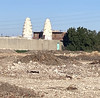
Small Pyramid, 22 Meters at the base with 3 steps dating to 3rd Dynasty and most likely attributed to Pharaoh Huni who built several cenotaphs all over Egypt to commemorate his own reign. The structure is made of rough limestone blocks bound by a mortar of clay and sand, and its east side is aligned with the Nile river. Investigated by Petrie and Quibell in 1895.
Archeologists argue about a pit under the pyramid, as it cannot be assertained wether it was there before or was made by possible tomb robbers, which is ilogical as this was a dummy pyramid.
You may be viewing yesterday's version of this page. To see the most up to date information please register for a free account.
Do not use the above information on other web sites or publications without permission of the contributor.
Nearby Images from Flickr
The above images may not be of the site on this page, but were taken nearby. They are loaded from Flickr so please click on them for image credits.
Click here to see more info for this site
Nearby sites
Click here to view sites on an interactive map of the areaKey: Red: member's photo, Blue: 3rd party photo, Yellow: other image, Green: no photo - please go there and take one, Grey: site destroyed
Download sites to:
KML (Google Earth)
GPX (GPS waypoints)
CSV (Garmin/Navman)
CSV (Excel)
To unlock full downloads you need to sign up as a Contributory Member. Otherwise downloads are limited to 50 sites.
Turn off the page maps and other distractions
Nearby sites listing. In the following links * = Image available
8.5km ENE 76° Gebtu* Ancient Village or Settlement
11.2km SSW 201° Nubt* Ancient Temple
19.4km NNW 341° Dendara Temple of Isis* Ancient Temple
19.4km NNW 341° Dendara Temple of Hathor* Ancient Temple
19.5km NNW 341° Dendara Mammisi of Nectanabo I* Ancient Temple
19.5km NNW 341° Dendara Mammisi of Trajan* Ancient Temple
26.5km SSW 208° Sankhkare Temple of Mentuhotep III* Ancient Temple
27.0km S 185° Madamut Temple of Montu* Ancient Temple
27.3km SSW 208° Theban Quarries Ancient Mine, Quarry or other Industry
29.1km SSW 201° El Gurna Temple of Seti I* Ancient Temple
29.2km SSW 207° Tomb of Ramses IV* Rock Cut Tomb
29.3km SSW 207° Tomb of Thutmose IV* Rock Cut Tomb
29.3km SSW 208° Tomb of Amenhotep III* Rock Cut Tomb
29.3km SSW 207° Tomb of the Sons of Ramses II* Rock Cut Tomb
29.3km SSW 207° Tomb of Ramses IX* Rock Cut Tomb
29.3km SSW 207° Tomb of Ramses II* Rock Cut Tomb
29.3km SSW 207° Valley of the Kings* Rock Cut Tomb
29.4km SSW 205° Temple of Hatshepsut* Ancient Temple
29.4km SSW 207° Tomb of Tutankhamun* Rock Cut Tomb
29.4km SSW 207° Tomb of Ramses VI* Rock Cut Tomb
29.4km SSW 207° Tomb of Ramses III* Rock Cut Tomb
29.4km SSW 195° Karnak Thutmose IV's Temple of Amun* Ancient Temple
29.5km SSW 195° Karnak Chapel of Amenhotep I* Ancient Temple
29.5km SSW 195° Karnak Shrine of Hatshepsut* Ancient Temple
29.5km SSW 195° Karnak Chapel of Thutmose IV* Ancient Temple
View more nearby sites and additional images


 We would like to know more about this location. Please feel free to add a brief description and any relevant information in your own language.
 Wir möchten mehr über diese Stätte erfahren. Bitte zögern Sie nicht, eine kurze Beschreibung und relevante Informationen in Deutsch hinzuzufügen.
 Nous aimerions en savoir encore un peu sur les lieux. S'il vous plaît n'hesitez pas à ajouter une courte description et tous les renseignements pertinents dans votre propre langue.
 Quisieramos informarnos un poco más de las lugares. No dude en añadir una breve descripción y otros datos relevantes en su propio idioma.