


<< Other Photo Pages >> El-Kurru Pyramids - Pyramid / Mastaba in Sudan
Submitted by AlexHunger on Monday, 18 March 2013 Page Views: 12282
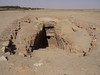
Multi-periodSite Name: El-Kurru Pyramids Alternative Name: El-Kourrou Pyramids, El KurruCountry: Sudan
NOTE: This site is 2.079 km away from the location you searched for.
Type: Pyramid / Mastaba
Nearest Town: Al Khurtum Nearest Village: Marawi
Latitude: 18.396823N Longitude: 31.756696E
Condition:
| 5 | Perfect |
| 4 | Almost Perfect |
| 3 | Reasonable but with some damage |
| 2 | Ruined but still recognisable as an ancient site |
| 1 | Pretty much destroyed, possibly visible as crop marks |
| 0 | No data. |
| -1 | Completely destroyed |
| 5 | Superb |
| 4 | Good |
| 3 | Ordinary |
| 2 | Not Good |
| 1 | Awful |
| 0 | No data. |
| 5 | Can be driven to, probably with disabled access |
| 4 | Short walk on a footpath |
| 3 | Requiring a bit more of a walk |
| 2 | A long walk |
| 1 | In the middle of nowhere, a nightmare to find |
| 0 | No data. |
| 5 | co-ordinates taken by GPS or official recorded co-ordinates |
| 4 | co-ordinates scaled from a detailed map |
| 3 | co-ordinates scaled from a bad map |
| 2 | co-ordinates of the nearest village |
| 1 | co-ordinates of the nearest town |
| 0 | no data |
Internal Links:
External Links:
")
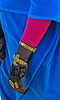
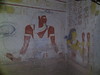
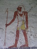
Cemetery in use between 900 and 700 BCE with royal and simpler tombs.
There are numerous, pyramids, tombs, tumuli and temples. Unesco World Heritage sites.
Note: Searching for the lost royal city of Nubia in northern Sudan
You may be viewing yesterday's version of this page. To see the most up to date information please register for a free account.
")
")
")
")
Do not use the above information on other web sites or publications without permission of the contributor.
Nearby Images from Flickr

The above images may not be of the site on this page, but were taken nearby. They are loaded from Flickr so please click on them for image credits.
Click here to see more info for this site
Nearby sites
Click here to view sites on an interactive map of the areaKey: Red: member's photo, Blue: 3rd party photo, Yellow: other image, Green: no photo - please go there and take one, Grey: site destroyed
Download sites to:
KML (Google Earth)
GPX (GPS waypoints)
CSV (Garmin/Navman)
CSV (Excel)
To unlock full downloads you need to sign up as a Contributory Member. Otherwise downloads are limited to 50 sites.
Turn off the page maps and other distractions
Nearby sites listing. In the following links * = Image available
703m SSW 200° El-Kurru Tumuli Round Barrow(s)
3.4km SSW 211° Zuma Tumuli Round Barrow(s)
11.4km NE 34° Sanam Temple Ancient Temple
16.1km NNE 23° Gebel Barkal Temple B700 Ancient Temple
16.1km NNE 23° Gebel Barkal Temple of Mut Ancient Temple
17.2km NNE 24° Karima Pyramids* Pyramid / Mastaba
17.2km NNE 27° Gebel Barkal Temple of Amon* Ancient Temple
17.3km NNE 26° Gebel Barkal Mountain and Rock Formation* Natural Stone / Erratic / Other Natural Feature
25.1km NE 42° Nuri Pyramids* Pyramid / Mastaba
82.5km SW 214° Wadi Abu Dom Rock Art Rock Art
229.3km NNW 326° Sesebi* Ancient Village or Settlement
236.9km E 97° Statue of Taharqa Carving
260.0km SE 137° El Kadada Neolithic Tomb Burial Chamber or Dolmen
263.2km SE 128° Meroë* Ancient Village or Settlement
266.2km SE 127° Meroë Pyramids* Pyramid / Mastaba
271.2km NNW 327° Soleb* Ancient Temple
271.7km SE 129° Abu Erteila Ancient Temple
284.7km NNW 328° Sedeinga* Pyramid / Mastaba
320.4km SSE 165° Sudan National Museum Museum
393.2km N 353° Buhen Stone Fort or Dun
438.3km N 358° Abu Simbel Temple of Ramses II* Ancient Temple
438.4km N 358° Abu Simbel Temple of Nefertari* Ancient Temple
469.3km NNW 347° Nabta Playa* Stone Circle
484.8km N 6° Temple of Amada* Ancient Temple
485.0km N 6° Temple of Derr* Ancient Temple
View more nearby sites and additional images


 We would like to know more about this location. Please feel free to add a brief description and any relevant information in your own language.
 Wir möchten mehr über diese Stätte erfahren. Bitte zögern Sie nicht, eine kurze Beschreibung und relevante Informationen in Deutsch hinzuzufügen.
 Nous aimerions en savoir encore un peu sur les lieux. S'il vous plaît n'hesitez pas à ajouter une courte description et tous les renseignements pertinents dans votre propre langue.
 Quisieramos informarnos un poco más de las lugares. No dude en añadir una breve descripción y otros datos relevantes en su propio idioma.