


<< Our Photo Pages >> Shepseskaf's Mastaba - Pyramid / Mastaba in Egypt in Lower Egypt (North)
Submitted by AlexHunger on Monday, 27 March 2006 Page Views: 5168
Multi-periodSite Name: Shepseskaf's MastabaCountry: Egypt Region: Lower Egypt (North) Type: Pyramid / Mastaba
Nearest Town: Cairo Nearest Village: Sakkara South
Latitude: 29.839030N Longitude: 31.215087E
Condition:
| 5 | Perfect |
| 4 | Almost Perfect |
| 3 | Reasonable but with some damage |
| 2 | Ruined but still recognisable as an ancient site |
| 1 | Pretty much destroyed, possibly visible as crop marks |
| 0 | No data. |
| -1 | Completely destroyed |
| 5 | Superb |
| 4 | Good |
| 3 | Ordinary |
| 2 | Not Good |
| 1 | Awful |
| 0 | No data. |
| 5 | Can be driven to, probably with disabled access |
| 4 | Short walk on a footpath |
| 3 | Requiring a bit more of a walk |
| 2 | A long walk |
| 1 | In the middle of nowhere, a nightmare to find |
| 0 | No data. |
| 5 | co-ordinates taken by GPS or official recorded co-ordinates |
| 4 | co-ordinates scaled from a detailed map |
| 3 | co-ordinates scaled from a bad map |
| 2 | co-ordinates of the nearest village |
| 1 | co-ordinates of the nearest town |
| 0 | no data |
Internal Links:
External Links:
")
Shepseskaf was the son of Menkaure and last Pharao of the 4th Dynasty. He paired off his half sister to Pharao Userkaf of the 5th Dynasty and left the kingdom to him.
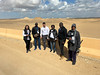
Shepseskaf built only this small 2 step mastaba about 2 Km north of the Dashour Red Pyramid. It is in an area only accessible to serious 4 wheel drive vehicles due to deep soft sand and could not be photographed from close up, although access is generally permitted.
You may be viewing yesterday's version of this page. To see the most up to date information please register for a free account.
")
Do not use the above information on other web sites or publications without permission of the contributor.
Nearby Images from Flickr


The above images may not be of the site on this page, but were taken nearby. They are loaded from Flickr so please click on them for image credits.
Click here to see more info for this site
Nearby sites
Click here to view sites on an interactive map of the areaKey: Red: member's photo, Blue: 3rd party photo, Yellow: other image, Green: no photo - please go there and take one, Grey: site destroyed
Download sites to:
KML (Google Earth)
GPX (GPS waypoints)
CSV (Garmin/Navman)
CSV (Excel)
To unlock full downloads you need to sign up as a Contributory Member. Otherwise downloads are limited to 50 sites.
Turn off the page maps and other distractions
Nearby sites listing. In the following links * = Image available
225m WNW 303° Pepy II Pyramid* Pyramid / Mastaba
401m NE 37° Ibi I Pyramid Pyramid / Mastaba
1.2km SE 145° Khendjer's Pyramid Pyramid / Mastaba
1.2km N 359° Merenre Nemtyemzaf Pyramid Pyramid / Mastaba
1.5km NNE 23° Djedkare Izezi Pyramid Pyramid / Mastaba
1.7km NNE 11° Pepy I Pyramid* Pyramid / Mastaba
2.5km SSE 155° Senusret III Pyramid Pyramid / Mastaba
3.0km N 357° Sekhemkhet's Pyramid Pyramid / Mastaba
3.1km NNE 14° Unas Valley Temple* Ancient Temple
3.2km NNW 344° Gisr el-Mudir Causewayed Enclosure
3.3km N 360° Unas Pyramid* Pyramid / Mastaba
3.3km N 4° Irukaptah Tomb* Chambered Tomb
3.4km N 4° Sakkara Djoser Complex* Ancient Temple
3.4km SSW 194° Red Pyramid* Pyramid / Mastaba
3.5km N 4° Sakkara Temple of Heb-Sed* Ancient Temple
3.6km S 169° Amenmenhat II Pyramid Pyramid / Mastaba
3.6km N 2° Sakkara Pyramid* Pyramid / Mastaba
3.8km N 358° Ptah Hotep Mastaba* Chambered Cairn
3.9km N 5° Userkaf's Pyramid* Pyramid / Mastaba
4.0km ENE 73° Memphis Museum* Museum
4.0km N 356° Serapeum at Sakkara* Ancient Temple
4.0km N 1° Knuhmhotep and Niankhkhnum Mastaba* Chambered Cairn
4.1km N 9° Teti I Pyramid* Pyramid / Mastaba
4.1km N 8° Mereruka Mastaba* Chambered Cairn
4.2km N 9° Kagemni Mastaba* Chambered Cairn
View more nearby sites and additional images


 We would like to know more about this location. Please feel free to add a brief description and any relevant information in your own language.
 Wir möchten mehr über diese Stätte erfahren. Bitte zögern Sie nicht, eine kurze Beschreibung und relevante Informationen in Deutsch hinzuzufügen.
 Nous aimerions en savoir encore un peu sur les lieux. S'il vous plaît n'hesitez pas à ajouter une courte description et tous les renseignements pertinents dans votre propre langue.
 Quisieramos informarnos un poco más de las lugares. No dude en añadir una breve descripción y otros datos relevantes en su propio idioma.