

<< Text Pages >> La Combe du Rat - Burial Chamber or Dolmen in France in Languedoc:Hérault (34)
Submitted by TheCaptain on Friday, 06 May 2011 Page Views: 1499
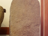
Neolithic and Bronze AgeSite Name: La Combe du RatCountry: France
NOTE: This site is 0.154 km away from the location you searched for.
Département: Languedoc:Hérault (34) Type: Burial Chamber or Dolmen
Nearest Town: Montpellier Nearest Village: Argelliers
Latitude: 43.698000N Longitude: 3.673000E
Condition:
| 5 | Perfect |
| 4 | Almost Perfect |
| 3 | Reasonable but with some damage |
| 2 | Ruined but still recognisable as an ancient site |
| 1 | Pretty much destroyed, possibly visible as crop marks |
| 0 | No data. |
| -1 | Completely destroyed |
| 5 | Superb |
| 4 | Good |
| 3 | Ordinary |
| 2 | Not Good |
| 1 | Awful |
| 0 | No data. |
| 5 | Can be driven to, probably with disabled access |
| 4 | Short walk on a footpath |
| 3 | Requiring a bit more of a walk |
| 2 | A long walk |
| 1 | In the middle of nowhere, a nightmare to find |
| 0 | No data. |
| 5 | co-ordinates taken by GPS or official recorded co-ordinates |
| 4 | co-ordinates scaled from a detailed map |
| 3 | co-ordinates scaled from a bad map |
| 2 | co-ordinates of the nearest village |
| 1 | co-ordinates of the nearest town |
| 0 | no data |
Be the first person to rate this site - see the 'Contribute!' box in the right hand menu.
Internal Links:
External Links:
burial chamber in Languedoc-Rousillon:Herault
La Combe du Rat is a burial chamber in the community of Argelliers, Departement of Herault, Region of Languedoc-Rousillon
You may be viewing yesterday's version of this page. To see the most up to date information please register for a free account.
Do not use the above information on other web sites or publications without permission of the contributor.
Nearby Images from Flickr
The above images may not be of the site on this page, but were taken nearby. They are loaded from Flickr so please click on them for image credits.
Click here to see more info for this site
Nearby sites
Click here to view sites on an interactive map of the areaKey: Red: member's photo, Blue: 3rd party photo, Yellow: other image, Green: no photo - please go there and take one, Grey: site destroyed
Download sites to:
KML (Google Earth)
GPX (GPS waypoints)
CSV (Garmin/Navman)
CSV (Excel)
To unlock full downloads you need to sign up as a Contributory Member. Otherwise downloads are limited to 50 sites.
Turn off the page maps and other distractions
Nearby sites listing. In the following links * = Image available
2.5km WNW 297° Boscorre Dolmen* Burial Chamber or Dolmen
2.6km ESE 115° Dolmen d'Argelliers* Burial Chamber or Dolmen
2.9km N 351° Pialapor* Ancient Village or Settlement
2.9km NNW 339° Dolmen de la Tourelle* Burial Chamber or Dolmen
3.0km N 4° Dolmen des Matelettes* Burial Chamber or Dolmen
3.3km WNW 293° Dolmen Carrière de l'Espinasse* Burial Chamber or Dolmen
3.4km N 4° Menhir des Matelettes* Standing Stone (Menhir)
3.4km W 272° Dolmen de Fraysse 4* Burial Chamber or Dolmen
3.6km W 272° Dolmen de Fraysse 2* Burial Chamber or Dolmen
3.7km W 271° Dolmen de Fraysse 3* Burial Chamber or Dolmen
3.7km NNE 25° Dolmen des Avinens* Burial Chamber or Dolmen
3.7km W 278° Dolmen de la Liquière 1* Burial Chamber or Dolmen
3.8km W 280° Dolmen de la Liquière 5* Burial Chamber or Dolmen
3.8km W 279° Dolmen de la Liquière 2* Burial Chamber or Dolmen
3.9km ESE 115° Dolmen du Mas Reynard 2* Burial Chamber or Dolmen
3.9km W 279° Dolmen de la Liquière 3* Burial Chamber or Dolmen
4.0km E 90° Oppidum Roc de Pampelune* Ancient Village or Settlement
4.0km ESE 113° Dolmen de Mas Reynard 1* Burial Chamber or Dolmen
4.0km W 274° Dolmen de Fraysse 1* Burial Chamber or Dolmen
4.1km ESE 118° Dolmen du Mas Reynard 3* Burial Chamber or Dolmen
4.2km SE 136° Dolmen de Lacoste 3* Burial Chamber or Dolmen
4.2km SE 138° Dolmen de Lacoste 1* Burial Chamber or Dolmen
4.3km SE 138° Dolmen de Lacoste 2* Burial Chamber or Dolmen
4.3km NE 48° Boussargues* Ancient Village or Settlement
4.3km W 280° Dolmen de la Liquière 4* Burial Chamber or Dolmen
View more nearby sites and additional images


 We would like to know more about this location. Please feel free to add a brief description and any relevant information in your own language.
 Wir möchten mehr über diese Stätte erfahren. Bitte zögern Sie nicht, eine kurze Beschreibung und relevante Informationen in Deutsch hinzuzufügen.
 Nous aimerions en savoir encore un peu sur les lieux. S'il vous plaît n'hesitez pas à ajouter une courte description et tous les renseignements pertinents dans votre propre langue.
 Quisieramos informarnos un poco más de las lugares. No dude en añadir una breve descripción y otros datos relevantes en su propio idioma.