
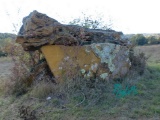

<< Text Pages >> Dolmen du Grézac 2 - Burial Chamber or Dolmen in France in Languedoc:Hérault (34)
Submitted by holger_rix on Wednesday, 24 February 2016 Page Views: 704
Neolithic and Bronze AgeSite Name: Dolmen du Grézac 2Country: France
NOTE: This site is 1.037 km away from the location you searched for.
Département: Languedoc:Hérault (34) Type: Burial Chamber or Dolmen
Nearest Town: Lodève Nearest Village: Saint-Martin
Latitude: 43.758356N Longitude: 3.288476E
Condition:
| 5 | Perfect |
| 4 | Almost Perfect |
| 3 | Reasonable but with some damage |
| 2 | Ruined but still recognisable as an ancient site |
| 1 | Pretty much destroyed, possibly visible as crop marks |
| 0 | No data. |
| -1 | Completely destroyed |
| 5 | Superb |
| 4 | Good |
| 3 | Ordinary |
| 2 | Not Good |
| 1 | Awful |
| 0 | No data. |
| 5 | Can be driven to, probably with disabled access |
| 4 | Short walk on a footpath |
| 3 | Requiring a bit more of a walk |
| 2 | A long walk |
| 1 | In the middle of nowhere, a nightmare to find |
| 0 | No data. |
| 5 | co-ordinates taken by GPS or official recorded co-ordinates |
| 4 | co-ordinates scaled from a detailed map |
| 3 | co-ordinates scaled from a bad map |
| 2 | co-ordinates of the nearest village |
| 1 | co-ordinates of the nearest town |
| 0 | no data |
Be the first person to rate this site - see the 'Contribute!' box in the right hand menu.
Internal Links:
External Links:
Burial Chamber (Dolmen) in Languedoc:Hérault (34)
Saint-Martin, Lodève, Hérault, Languedoc-Roussillon-Midi-Pyrénées
Source: T4T35.fr
You may be viewing yesterday's version of this page. To see the most up to date information please register for a free account.
Do not use the above information on other web sites or publications without permission of the contributor.
Nearby Images from Flickr


The above images may not be of the site on this page, but were taken nearby. They are loaded from Flickr so please click on them for image credits.
Click here to see more info for this site
Nearby sites
Click here to view sites on an interactive map of the areaKey: Red: member's photo, Blue: 3rd party photo, Yellow: other image, Green: no photo - please go there and take one, Grey: site destroyed
Download sites to:
KML (Google Earth)
GPX (GPS waypoints)
CSV (Garmin/Navman)
CSV (Excel)
To unlock full downloads you need to sign up as a Contributory Member. Otherwise downloads are limited to 50 sites.
Turn off the page maps and other distractions
Nearby sites listing. In the following links * = Image available
205m ENE 63° Dolmen du Grézac 1 Burial Chamber or Dolmen
1.8km SE 127° Oppidum du Grézac* Ancient Village or Settlement
3.9km NNE 30° Dolmen de Murène Burial Chamber or Dolmen
4.1km SE 138° Grotte fermée Cave or Rock Shelter
5.2km ENE 63° Dolmen des Coutelles 2* Burial Chamber or Dolmen
5.4km NNE 23° Dolmen de Pégairolles de l'Escalette Burial Chamber or Dolmen
5.5km ENE 60° Dolmen des Coutelles 1* Burial Chamber or Dolmen
6.6km SSE 151° Grotte de Tréviols Cave or Rock Shelter
7.0km ESE 115° Coste-Rouge Dolmen* Burial Chamber or Dolmen
7.2km ESE 114° Grandmont Menhir* Standing Stone (Menhir)
7.2km ESE 114° Les Ecuelles du Diable* Holed Stone
7.3km SSW 196° Dolmens du Mas Trinquier* Burial Chamber or Dolmen
7.5km ESE 112° Dolmen du Belvédère* Burial Chamber or Dolmen
7.5km ESE 113° Grandmont Menhir 2* Standing Stone (Menhir)
7.6km ENE 64° Dolmens de Moulenti* Burial Chamber or Dolmen
7.6km ESE 112° Grandmont Dolmen 2* Burial Chamber or Dolmen
7.6km SSW 196° Dolmen de Lavalette* Burial Chamber or Dolmen
7.7km NE 36° Menhir stèle Puech Doussieu* Standing Stone (Menhir)
7.7km NE 34° Dolmen de Puech Doussieu* Chambered Tomb
7.7km NE 36° Cercle de pierres 1 Puech Doussieu* Ancient Village or Settlement
7.7km NE 36° Tumulus Doussieu 2 & 3* Round Barrow(s)
7.8km WSW 253° Dolmen de la Planquette Burial Chamber or Dolmen
7.8km W 268° La Quille menhir Standing Stone (Menhir)
7.9km NNE 33° Tumulus Portail Puech Doussieu* Round Barrow(s)
8.1km ESE 107° Bruyère d'Usclas* Burial Chamber or Dolmen
View more nearby sites and additional images


 We would like to know more about this location. Please feel free to add a brief description and any relevant information in your own language.
 Wir möchten mehr über diese Stätte erfahren. Bitte zögern Sie nicht, eine kurze Beschreibung und relevante Informationen in Deutsch hinzuzufügen.
 Nous aimerions en savoir encore un peu sur les lieux. S'il vous plaît n'hesitez pas à ajouter une courte description et tous les renseignements pertinents dans votre propre langue.
 Quisieramos informarnos un poco más de las lugares. No dude en añadir una breve descripción y otros datos relevantes en su propio idioma.