

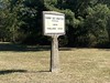
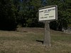
<< Our Photo Pages >> Menhir de Villars - Standing Stone (Menhir) in France in Auvergne:Puy-de-Dôme (63)
Submitted by TheCaptain on Saturday, 16 April 2005 Page Views: 4279
Neolithic and Bronze AgeSite Name: Menhir de VillarsCountry: France
NOTE: This site is 1.82 km away from the location you searched for.
Département: Auvergne:Puy-de-Dôme (63) Type: Standing Stone (Menhir)
Nearest Town: Clermont-Ferrand Nearest Village: Orcines
Latitude: 45.777140N Longitude: 3.031970E
Condition:
| 5 | Perfect |
| 4 | Almost Perfect |
| 3 | Reasonable but with some damage |
| 2 | Ruined but still recognisable as an ancient site |
| 1 | Pretty much destroyed, possibly visible as crop marks |
| 0 | No data. |
| -1 | Completely destroyed |
| 5 | Superb |
| 4 | Good |
| 3 | Ordinary |
| 2 | Not Good |
| 1 | Awful |
| 0 | No data. |
| 5 | Can be driven to, probably with disabled access |
| 4 | Short walk on a footpath |
| 3 | Requiring a bit more of a walk |
| 2 | A long walk |
| 1 | In the middle of nowhere, a nightmare to find |
| 0 | No data. |
| 5 | co-ordinates taken by GPS or official recorded co-ordinates |
| 4 | co-ordinates scaled from a detailed map |
| 3 | co-ordinates scaled from a bad map |
| 2 | co-ordinates of the nearest village |
| 1 | co-ordinates of the nearest town |
| 0 | no data |
Internal Links:
External Links:
I have visited· I would like to visit
alchemille visited on 26th Jun 2014 - their rating: Cond: 5 Amb: 5 Access: 5 Easy to find it, GPS: ORCINES, place de la pierre levée.
the menhir has been crowned with a cross, on one side there is a carving of Christ crucified and on he other side a figure which appears to be a madonna.
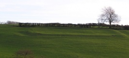
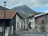
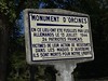
TheCaptain saw from a distance on 26th Jul 2005 This little menhir, less than 2 metres tall, can be found in the hamlet of Villars, near to the lavoir in the village square. On the top of the menhir is mounted a curious cross with a carving of Christ on it. Again, I missed this only because I did not know of it. There were once three menhirs to be found in the commune of Orcines.
")
On the top of the menhir is mounted a curious cross with a carving of Christ on it.
There were once three menhirs to be found in the commune of Orcines.
IMPORTANT NOTE: Position of site scaled from a detailed map source.
You may be viewing yesterday's version of this page. To see the most up to date information please register for a free account.
")
")
Do not use the above information on other web sites or publications without permission of the contributor.
TheCaptain has found this location on Google Street View:
Nearby Images from Flickr
The above images may not be of the site on this page, but were taken nearby. They are loaded from Flickr so please click on them for image credits.
Click here to see more info for this site
Nearby sites
Click here to view sites on an interactive map of the areaKey: Red: member's photo, Blue: 3rd party photo, Yellow: other image, Green: no photo - please go there and take one, Grey: site destroyed
Download sites to:
KML (Google Earth)
GPX (GPS waypoints)
CSV (Garmin/Navman)
CSV (Excel)
To unlock full downloads you need to sign up as a Contributory Member. Otherwise downloads are limited to 50 sites.
Turn off the page maps and other distractions
Nearby sites listing. In the following links * = Image available
4.1km NE 44° Oppidum des Côtes de Clermont Ancient Village or Settlement
4.7km S 188° Thedes Menhir* Standing Stone (Menhir)
5.3km W 263° Temple de Mercure* Ancient Temple
5.9km S 170° Menhir de Berzet* Standing Stone (Menhir)
6.2km SSW 203° Menhir de Chatrat* Standing Stone (Menhir)
6.7km ESE 122° Pierre Piquée d'Aubière, Rue Pourliat* Marker Stone
6.8km S 174° Dolmen de Samson* Burial Chamber or Dolmen
7.4km E 96° Orthostat de la Sarre Burial Chamber or Dolmen
7.9km ESE 106° Pierre Piquée du Pont d'Aubières* Standing Stone (Menhir)
8.0km S 186° Menhir de Theix* Standing Stone (Menhir)
8.2km E 81° Menhir de Brézet Standing Stone (Menhir)
8.9km E 86° Menhir du Puy de la Poix* Standing Stone (Menhir)
9.0km E 89° Menhir de la Grande Borne* Standing Stone (Menhir)
9.4km SE 132° Plateau de Gergovie* Ancient Village or Settlement
9.5km SSE 168° Chaos de Flore* Rock Outcrop
10.3km SSW 208° Grotte de Ribbe-Haute Cave or Rock Shelter
14.0km NNE 31° Stade de la Varenne Menhir* Standing Stone (Menhir)
14.7km N 9° St-Hyppolyte burial chamber Burial Chamber or Dolmen
14.8km SSW 193° Pierre Longue (Fohet)* Standing Stone (Menhir)
15.1km S 179° Cournols allée couverte* Passage Grave
15.3km ESE 122° Orthostat of Martres de Veyre* Chambered Tomb
15.3km SE 139° Pierrefade (Charvilhat) Standing Stone (Menhir)
15.7km S 179° Pierre Branlante de Cournols Natural Stone / Erratic / Other Natural Feature
15.7km S 179° Les Pierres Longues de Cournols* Natural Stone / Erratic / Other Natural Feature
17.0km E 94° Oppidum du Puy du Mur Ancient Village or Settlement
View more nearby sites and additional images


 We would like to know more about this location. Please feel free to add a brief description and any relevant information in your own language.
 Wir möchten mehr über diese Stätte erfahren. Bitte zögern Sie nicht, eine kurze Beschreibung und relevante Informationen in Deutsch hinzuzufügen.
 Nous aimerions en savoir encore un peu sur les lieux. S'il vous plaît n'hesitez pas à ajouter une courte description et tous les renseignements pertinents dans votre propre langue.
 Quisieramos informarnos un poco más de las lugares. No dude en añadir una breve descripción y otros datos relevantes en su propio idioma.