

<< Our Photo Pages >> Tripolis - Ancient Village or Settlement in Turkey
Submitted by davidmorgan on Wednesday, 26 January 2011 Page Views: 5098
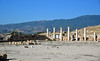
Multi-periodSite Name: TripolisCountry: Turkey Type: Ancient Village or Settlement
Nearest Town: Buldan Nearest Village: Yenicekent
Latitude: 38.038841N Longitude: 28.950078E
Condition:
| 5 | Perfect |
| 4 | Almost Perfect |
| 3 | Reasonable but with some damage |
| 2 | Ruined but still recognisable as an ancient site |
| 1 | Pretty much destroyed, possibly visible as crop marks |
| 0 | No data. |
| -1 | Completely destroyed |
| 5 | Superb |
| 4 | Good |
| 3 | Ordinary |
| 2 | Not Good |
| 1 | Awful |
| 0 | No data. |
| 5 | Can be driven to, probably with disabled access |
| 4 | Short walk on a footpath |
| 3 | Requiring a bit more of a walk |
| 2 | A long walk |
| 1 | In the middle of nowhere, a nightmare to find |
| 0 | No data. |
| 5 | co-ordinates taken by GPS or official recorded co-ordinates |
| 4 | co-ordinates scaled from a detailed map |
| 3 | co-ordinates scaled from a bad map |
| 2 | co-ordinates of the nearest village |
| 1 | co-ordinates of the nearest town |
| 0 | no data |
Internal Links:
External Links:
I have visited· I would like to visit
davidmorgan has visited here
")
Originally a Lydian town, all that remains are Roman ruins from the 1st century CE.
You may be viewing yesterday's version of this page. To see the most up to date information please register for a free account.
")
")
")
")
Do not use the above information on other web sites or publications without permission of the contributor.
Nearby Images from Flickr
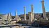


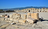
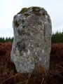
The above images may not be of the site on this page, but were taken nearby. They are loaded from Flickr so please click on them for image credits.
Click here to see more info for this site
Nearby sites
Click here to view sites on an interactive map of the areaKey: Red: member's photo, Blue: 3rd party photo, Yellow: other image, Green: no photo - please go there and take one, Grey: site destroyed
Download sites to:
KML (Google Earth)
GPX (GPS waypoints)
CSV (Garmin/Navman)
CSV (Excel)
To unlock full downloads you need to sign up as a Contributory Member. Otherwise downloads are limited to 50 sites.
Turn off the page maps and other distractions
Nearby sites listing. In the following links * = Image available
18.6km SE 126° Hierapolis Mausoleums* Rock Cut Tomb
19.9km SE 130° Hierapolis* Ancient Village or Settlement
26.5km SSE 148° Laodikeia* Ancient Village or Settlement
39.1km SE 136° Colossae* Ancient Village or Settlement
41.8km SSW 208° Aphrodisias* Ancient Village or Settlement
46.3km S 170° Herakleia Hieron Ancient Temple
50.3km NW 312° Gavurtepe Ancient Village or Settlement
51.3km E 84° Eksi Hoyuk Ancient Village or Settlement
70.0km ENE 70° Beycesultan* Ancient Village or Settlement
72.1km WSW 258° Nysa* Ancient Village or Settlement
75.4km WSW 258° Acharaca Ancient Village or Settlement
79.4km SW 222° Hyllarima* Ancient Village or Settlement
94.0km WNW 302° Sardis Temple of Artemis* Ancient Temple
94.0km WNW 302° Sardis* Ancient Village or Settlement
97.7km WSW 258° Aydin Archaeological Museum* Museum
98.3km WSW 240° Alabanda* Ancient Village or Settlement
98.7km NW 307° Alyattes Tomb* Round Barrow(s)
99.6km W 259° Tralleis Ancient Village or Settlement
101.4km NW 306° Bin Tepe Tumuli* Round Barrow(s)
108.7km SW 228° Lagina Temple of Hecate* Ancient Temple
108.7km SSE 154° Kibyra* Ancient Village or Settlement
110.2km NW 306° Kaymakci Hill Ancient Village or Settlement
111.0km SE 134° Camur Hoyuk Ancient Village or Settlement
111.7km ESE 117° Hacilar* Ancient Village or Settlement
112.0km WSW 242° Alinda* Ancient Village or Settlement
View more nearby sites and additional images


 We would like to know more about this location. Please feel free to add a brief description and any relevant information in your own language.
 Wir möchten mehr über diese Stätte erfahren. Bitte zögern Sie nicht, eine kurze Beschreibung und relevante Informationen in Deutsch hinzuzufügen.
 Nous aimerions en savoir encore un peu sur les lieux. S'il vous plaît n'hesitez pas à ajouter une courte description et tous les renseignements pertinents dans votre propre langue.
 Quisieramos informarnos un poco más de las lugares. No dude en añadir una breve descripción y otros datos relevantes en su propio idioma.