


<< Our Photo Pages >> Tunnel of Eupalinos - Ancient Mine, Quarry or other Industry in Greece in Greek Islands
Submitted by Andy B on Wednesday, 12 September 2012 Page Views: 4132
Multi-periodSite Name: Tunnel of Eupalinos Alternative Name: Samos Tunnel, Eupalinian aqueduct, Efpalinio orygma, ΕυπαλίνεCountry: Greece Region: Greek Islands Type: Ancient Mine, Quarry or other Industry
Nearest Town: Samos Island
Latitude: 37.694000N Longitude: 26.930000E
Condition:
| 5 | Perfect |
| 4 | Almost Perfect |
| 3 | Reasonable but with some damage |
| 2 | Ruined but still recognisable as an ancient site |
| 1 | Pretty much destroyed, possibly visible as crop marks |
| 0 | No data. |
| -1 | Completely destroyed |
| 5 | Superb |
| 4 | Good |
| 3 | Ordinary |
| 2 | Not Good |
| 1 | Awful |
| 0 | No data. |
| 5 | Can be driven to, probably with disabled access |
| 4 | Short walk on a footpath |
| 3 | Requiring a bit more of a walk |
| 2 | A long walk |
| 1 | In the middle of nowhere, a nightmare to find |
| 0 | No data. |
| 5 | co-ordinates taken by GPS or official recorded co-ordinates |
| 4 | co-ordinates scaled from a detailed map |
| 3 | co-ordinates scaled from a bad map |
| 2 | co-ordinates of the nearest village |
| 1 | co-ordinates of the nearest town |
| 0 | no data |
Internal Links:
External Links:
I have visited· I would like to visit
43559959 would like to visit
Andy B has visited here
")
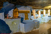
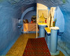
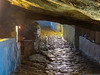
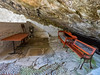
The tunnel took water from an inland spring, which was roofed over and thus concealed from enemies. A buried channel, with periodic inspection shafts, winds along the hillside to the northern tunnel mouth. A similar hidden channel, buried just below the surface of the ground, leads from the southern exit eastwards to the town of Pythagoreion.
The Eupalinian subterranean aqueduct is famous today as one of the masterpieces of ancient engineering. The engineer Eupalinos was aware that mistakes in measurement could make him miss the meeting point of the two teams, either horizontally or vertically. He therefore employed the following techniques
Read more at Wikipedia.
You may be viewing yesterday's version of this page. To see the most up to date information please register for a free account.
Do not use the above information on other web sites or publications without permission of the contributor.
Nearby Images from Flickr

The above images may not be of the site on this page, but were taken nearby. They are loaded from Flickr so please click on them for image credits.
Click here to see more info for this site
Nearby sites
Click here to view sites on an interactive map of the areaKey: Red: member's photo, Blue: 3rd party photo, Yellow: other image, Green: no photo - please go there and take one, Grey: site destroyed
Download sites to:
KML (Google Earth)
GPX (GPS waypoints)
CSV (Garmin/Navman)
CSV (Excel)
To unlock full downloads you need to sign up as a Contributory Member. Otherwise downloads are limited to 50 sites.
Turn off the page maps and other distractions
Nearby sites listing. In the following links * = Image available
4.6km WSW 237° Heraion of Samos* Ancient Temple
26.9km E 85° Poseidon Helikonios Sanctuary Ancient Temple
32.5km E 97° Priene* Ancient Village or Settlement
32.5km E 97° Priene Temple of Athena* Ancient Temple
35.5km ESE 121° Miletus* Ancient Village or Settlement
41.0km NE 35° Notion* Ancient Village or Settlement
41.6km NNE 34° Claros Temple of Apollo* Ancient Village or Settlement
42.7km N 4° Lebedos* Ancient Village or Settlement
42.9km NE 55° Mary's House and Mary's Well* Holy Well or Sacred Spring
44.6km SE 140° Didyma Sanctuary of Artemis* Ancient Temple
44.8km SE 140° Didyma Temple of Apollo* Ancient Temple
44.9km ESE 103° Myous* Ancient Village or Settlement
45.3km NE 53° Ephesus* Ancient Village or Settlement
45.9km NE 55° Cukurici Mound* Ancient Village or Settlement
47.5km NE 53° Ephesus Temple of Artemis* Ancient Temple
47.8km NE 53° Ephesus Museum* Museum
48.0km NE 53° Ayasuluk Hill* Ancient Village or Settlement
49.7km NNE 22° Kolophon Ancient Village or Settlement
54.4km NNW 347° Teos harbour* Ancient Village or Settlement
54.9km NNW 347° Teos cistern* Ancient Village or Settlement
55.2km NNW 347° Teos* Ancient Village or Settlement
55.4km ENE 71° Magnesia on the Meander* Ancient Village or Settlement
56.6km ESE 112° Heracleia* Ancient Village or Settlement
58.1km SSW 191° Leros Temple of Artemis Ancient Temple
59.1km NE 36° Metropolis* Ancient Village or Settlement
View more nearby sites and additional images


 We would like to know more about this location. Please feel free to add a brief description and any relevant information in your own language.
 Wir möchten mehr über diese Stätte erfahren. Bitte zögern Sie nicht, eine kurze Beschreibung und relevante Informationen in Deutsch hinzuzufügen.
 Nous aimerions en savoir encore un peu sur les lieux. S'il vous plaît n'hesitez pas à ajouter une courte description et tous les renseignements pertinents dans votre propre langue.
 Quisieramos informarnos un poco más de las lugares. No dude en añadir una breve descripción y otros datos relevantes en su propio idioma.