


<< Text Pages >> Ancient Dystos - Ancient Village or Settlement in Greece in Greek Islands
Submitted by AlexHunger on Sunday, 12 November 2006 Page Views: 3669
Multi-periodSite Name: Ancient DystosCountry: Greece
NOTE: This site is 58.242 km away from the location you searched for.
Region: Greek Islands Type: Ancient Village or Settlement
Nearest Town: Island of Euboa Nearest Village: Dystos
Latitude: 38.354862N Longitude: 24.144059E
Condition:
| 5 | Perfect |
| 4 | Almost Perfect |
| 3 | Reasonable but with some damage |
| 2 | Ruined but still recognisable as an ancient site |
| 1 | Pretty much destroyed, possibly visible as crop marks |
| 0 | No data. |
| -1 | Completely destroyed |
| 5 | Superb |
| 4 | Good |
| 3 | Ordinary |
| 2 | Not Good |
| 1 | Awful |
| 0 | No data. |
| 5 | Can be driven to, probably with disabled access |
| 4 | Short walk on a footpath |
| 3 | Requiring a bit more of a walk |
| 2 | A long walk |
| 1 | In the middle of nowhere, a nightmare to find |
| 0 | No data. |
| 5 | co-ordinates taken by GPS or official recorded co-ordinates |
| 4 | co-ordinates scaled from a detailed map |
| 3 | co-ordinates scaled from a bad map |
| 2 | co-ordinates of the nearest village |
| 1 | co-ordinates of the nearest town |
| 0 | no data |
Be the first person to rate this site - see the 'Contribute!' box in the right hand menu.
Internal Links:
External Links:
Ancient Village or Settlement in Greek Islands (Aegean etc)
5th century BCE Polygonal town walls, later turned into a fort by the Venitians
You may be viewing yesterday's version of this page. To see the most up to date information please register for a free account.
Do not use the above information on other web sites or publications without permission of the contributor.
Nearby Images from Flickr

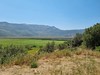

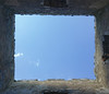

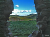
The above images may not be of the site on this page, but were taken nearby. They are loaded from Flickr so please click on them for image credits.
Click here to see more info for this site
Nearby sites
Click here to view sites on an interactive map of the areaKey: Red: member's photo, Blue: 3rd party photo, Yellow: other image, Green: no photo - please go there and take one, Grey: site destroyed
Download sites to:
KML (Google Earth)
GPX (GPS waypoints)
CSV (Garmin/Navman)
CSV (Excel)
To unlock full downloads you need to sign up as a Contributory Member. Otherwise downloads are limited to 50 sites.
Turn off the page maps and other distractions
Nearby sites listing. In the following links * = Image available
17.9km SW 215° Ramnous* Hillfort
18.4km SW 214° Ramnous Temple of Nemesis* Ancient Temple
18.4km SW 214° Ramnous Temple of Themis* Ancient Temple
22.9km SSE 154° Dragonhouses* Ancient Temple
26.9km SSW 208° Trophy of the Athenians* Sculptured Stone
27.1km SSE 161° Kapsala Drakospita* Ancient Temple
27.1km WSW 255° Amfiaraio* Ancient Temple
28.7km SW 220° Pan Cave Cave or Rock Shelter
28.7km SW 220° Temple of Pythian Apollo* Ancient Temple
29.5km SSW 212° Tsepi Early Helladic Graves* Chambered Tomb
30.1km SSW 209° Tumulus of the Athenians* Round Barrow(s)
30.8km SSW 213° Vranas Mycenaean Tholos* Chambered Cairn
30.9km SSW 214° Tumulus of the Plataeans* Round Barrow(s)
31.1km SW 214° Vranas Middle Helladic Graves* Chambered Tomb
31.1km SSW 214° Marathon Museum* Museum
31.2km W 279° Eretria* Ancient Village or Settlement
31.5km SSW 207° Sanctuary of the Egyptian Gods* Ancient Temple
39.9km SSW 195° Askitario* Ancient Village or Settlement
40.8km W 279° Xeropolis Ancient Village or Settlement
43.4km SSW 196° Temple of Artemis Tauropolos* Ancient Temple
44.1km SE 143° Cylindroi* Ancient Mine, Quarry or other Industry
48.9km W 280° Aulis Sanctuary of Artemis* Ancient Village or Settlement
49.5km SSW 195° Vravrona Temple of Artemis* Ancient Temple
49.5km SSW 195° Vravrona Tomb of Iphigenia* Chambered Cairn
49.5km SSW 195° Vravrona Museum* Museum
View more nearby sites and additional images


 We would like to know more about this location. Please feel free to add a brief description and any relevant information in your own language.
 Wir möchten mehr über diese Stätte erfahren. Bitte zögern Sie nicht, eine kurze Beschreibung und relevante Informationen in Deutsch hinzuzufügen.
 Nous aimerions en savoir encore un peu sur les lieux. S'il vous plaît n'hesitez pas à ajouter une courte description et tous les renseignements pertinents dans votre propre langue.
 Quisieramos informarnos un poco más de las lugares. No dude en añadir una breve descripción y otros datos relevantes en su propio idioma.