

<< Our Photo Pages >> Sanctuary of Apollo Ptoios - Ancient Temple in Greece in Central Greece
Submitted by AlexHunger on Wednesday, 03 October 2007 Page Views: 10397
Neolithic and Bronze AgeSite Name: Sanctuary of Apollo Ptoios Alternative Name: Ptoion Sanctuary of Apollo, PtoonCountry: Greece
NOTE: This site is 24.423 km away from the location you searched for.
Region: Central Greece Type: Ancient Temple
Nearest Town: Thebes Nearest Village: Akraífnion
Latitude: 38.459139N Longitude: 23.251015E
Condition:
| 5 | Perfect |
| 4 | Almost Perfect |
| 3 | Reasonable but with some damage |
| 2 | Ruined but still recognisable as an ancient site |
| 1 | Pretty much destroyed, possibly visible as crop marks |
| 0 | No data. |
| -1 | Completely destroyed |
| 5 | Superb |
| 4 | Good |
| 3 | Ordinary |
| 2 | Not Good |
| 1 | Awful |
| 0 | No data. |
| 5 | Can be driven to, probably with disabled access |
| 4 | Short walk on a footpath |
| 3 | Requiring a bit more of a walk |
| 2 | A long walk |
| 1 | In the middle of nowhere, a nightmare to find |
| 0 | No data. |
| 5 | co-ordinates taken by GPS or official recorded co-ordinates |
| 4 | co-ordinates scaled from a detailed map |
| 3 | co-ordinates scaled from a bad map |
| 2 | co-ordinates of the nearest village |
| 1 | co-ordinates of the nearest town |
| 0 | no data |
Internal Links:
External Links:
I have visited· I would like to visit
davidmorgan has visited here
")
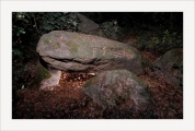
Remains of temple measuring 25 metres by 12 metres which had 13 by 6 columns.
Further info from Antonios: The monuments were arranged on three terraces, comprising a temple (archaic-hellenistic period) around which stood statues of kouroi and oracular tripods. On the lower terraces are the stoas, a large cistern and the oracular spring.
You may be viewing yesterday's version of this page. To see the most up to date information please register for a free account.
")
")
")
")
")
")
Do not use the above information on other web sites or publications without permission of the contributor.
Click here to see more info for this site
Nearby sites
Click here to view sites on an interactive map of the areaKey: Red: member's photo, Blue: 3rd party photo, Yellow: other image, Green: no photo - please go there and take one, Grey: site destroyed
Download sites to:
KML (Google Earth)
GPX (GPS waypoints)
CSV (Garmin/Navman)
CSV (Excel)
To unlock full downloads you need to sign up as a Contributory Member. Otherwise downloads are limited to 50 sites.
Turn off the page maps and other distractions
Nearby sites listing. In the following links * = Image available
6.4km WNW 296° Gla.* Hillfort
16.2km SSE 159° Thebes Museum* Museum
16.5km SSE 158° Thebes Mycenaean Tomb* Rock Cut Tomb
17.1km SSE 159° Temple of Apollo Ismenios Ancient Temple
24.4km W 279° Treasury of Minyas* Cairn
24.7km W 279° Orchomenos Temple Ancient Temple
26.7km S 176° Ancient Plataea* Ancient Village or Settlement
29.9km E 95° Aulis Sanctuary of Artemis* Ancient Village or Settlement
32.1km WNW 295° Abai (Greece)* Ancient Village or Settlement
32.3km W 277° Macedonian Tumulus at Chaeronea Chambered Tomb
32.9km SSE 161° Eleutherae* Promontory Fort / Cliff Castle
33.7km WNW 297° Hyampolis* Ancient Village or Settlement
34.2km W 265° Lebadeia Temple of Zeus* Ancient Temple
34.2km S 183° Shrine of Melampous* Ancient Temple
34.7km S 183° Aigosthena Fortress* Stone Fort or Dun
35.3km W 277° Lion of Chaeronea* Carving
36.2km SSE 155° Tower of Oinoe* Promontory Fort / Cliff Castle
36.7km WNW 303° Hyampolis Sanctuary of Artemis and Apollo* Ancient Temple
37.9km E 98° Xeropolis Ancient Village or Settlement
44.2km WNW 300° Elateia Temple of Athena Kranaia Ancient Temple
47.4km E 98° Eretria* Ancient Village or Settlement
51.8km SSE 153° Temple of Eleusis* Ancient Temple
53.5km SE 137° Fili Fortress* Promontory Fort / Cliff Castle
55.0km ESE 110° Amfiaraio* Ancient Temple
59.2km SW 216° Heraion of Perachora* Ancient Temple
View more nearby sites and additional images


 We would like to know more about this location. Please feel free to add a brief description and any relevant information in your own language.
 Wir möchten mehr über diese Stätte erfahren. Bitte zögern Sie nicht, eine kurze Beschreibung und relevante Informationen in Deutsch hinzuzufügen.
 Nous aimerions en savoir encore un peu sur les lieux. S'il vous plaît n'hesitez pas à ajouter une courte description et tous les renseignements pertinents dans votre propre langue.
 Quisieramos informarnos un poco más de las lugares. No dude en añadir una breve descripción y otros datos relevantes en su propio idioma.