


<< Our Photo Pages >> Cyrene Temple of Apollo - Ancient Temple in Libya
Submitted by AlexHunger on Wednesday, 12 November 2008 Page Views: 9528
Roman, Greek and ClassicalSite Name: Cyrene Temple of Apollo Alternative Name: Cyrene Sanctuary of ApolloCountry: Libya Type: Ancient Temple
Nearest Town: Benghazi Nearest Village: Al Bayda'
Latitude: 32.823440N Longitude: 21.852630E
Condition:
| 5 | Perfect |
| 4 | Almost Perfect |
| 3 | Reasonable but with some damage |
| 2 | Ruined but still recognisable as an ancient site |
| 1 | Pretty much destroyed, possibly visible as crop marks |
| 0 | No data. |
| -1 | Completely destroyed |
| 5 | Superb |
| 4 | Good |
| 3 | Ordinary |
| 2 | Not Good |
| 1 | Awful |
| 0 | No data. |
| 5 | Can be driven to, probably with disabled access |
| 4 | Short walk on a footpath |
| 3 | Requiring a bit more of a walk |
| 2 | A long walk |
| 1 | In the middle of nowhere, a nightmare to find |
| 0 | No data. |
| 5 | co-ordinates taken by GPS or official recorded co-ordinates |
| 4 | co-ordinates scaled from a detailed map |
| 3 | co-ordinates scaled from a bad map |
| 2 | co-ordinates of the nearest village |
| 1 | co-ordinates of the nearest town |
| 0 | no data |
Internal Links:
External Links:
")
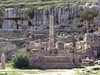
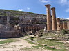
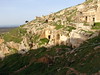
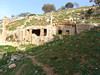
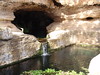
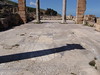
The 6-5th century BCE temple of Apollo had 11 by 6 Doric but unfluted columns. It is located on a largel man-made cliff platform about 1 kilometer further south and below the actual city of Cyrene and conected via a sacred processional path. The location was chosen on account of the natural spring located there which made the entire town viable. There are numerous other temples as well as Baths in the immediate vicinity. The Libyan natives made rock cut tombs in the cliffs before the arrival of the Greeks. Italian archeologists restored it to the present state since 1957. All work ceased in 1974. It's now a Unesco World Heritage site.
You may be viewing yesterday's version of this page. To see the most up to date information please register for a free account.
")
")
")
Do not use the above information on other web sites or publications without permission of the contributor.
Nearby Images from Flickr
The above images may not be of the site on this page, but were taken nearby. They are loaded from Flickr so please click on them for image credits.
Click here to see more info for this site
Nearby sites
Click here to view sites on an interactive map of the areaKey: Red: member's photo, Blue: 3rd party photo, Yellow: other image, Green: no photo - please go there and take one, Grey: site destroyed
Download sites to:
KML (Google Earth)
GPX (GPS waypoints)
CSV (Garmin/Navman)
CSV (Excel)
To unlock full downloads you need to sign up as a Contributory Member. Otherwise downloads are limited to 50 sites.
Turn off the page maps and other distractions
Nearby sites listing. In the following links * = Image available
23m NNE 24° Cyrene Temple of Artemis* Ancient Temple
38m ESE 114° Cyrene Sanctuary of Apollo* Ancient Temple
48m SSW 195° Cyrene Sacred Spring* Holy Well or Sacred Spring
73m SSW 193° Cyrene Rock Cut Tombs* Rock Cut Tomb
404m NE 42° Cyrene Necropolis* Rock Cut Tomb
843m SE 136° Cyrene* Ancient Village or Settlement
933m E 98° Cyrene Temple of Zeus* Ancient Temple
1.1km SSE 159° Cyrene Temple of Demeter* Ancient Temple
10.6km WSW 237° Al Bayda' Asklepieion Ancient Temple
14.2km NE 52° Apollonia (Libya)* Ancient Village or Settlement
22.0km SSW 197° Slonta Grotto Cave or Rock Shelter
29.9km E 90° Snibat al-Awila Tombs Portal Tomb
85.3km W 262° Ptolemais Ancient Village or Settlement
85.7km W 262° Ptolemais Museum Ancient Village or Settlement
124.6km WSW 255° Taucheira Ancient Village or Settlement
184.9km WSW 246° Euesperides* Ancient Village or Settlement
322.7km NNE 33° Lissos (Crete)* Ancient Village or Settlement
327.2km NNE 33° Elyros* Ancient Village or Settlement
337.8km NNE 27° Falasarna* Ancient Village or Settlement
359.3km NE 35° Stylos Tholos Tomb* Chambered Tomb
359.4km NE 35° Stylos Settlement* Ancient Village or Settlement
359.6km NNE 33° Chania Archaeological Museum* Museum
359.8km NNE 33° Kydonia* Ancient Village or Settlement
360.1km NE 47° Matala* Rock Cut Tomb
361.3km NE 35° Aptera* Ancient Village or Settlement
View more nearby sites and additional images


 We would like to know more about this location. Please feel free to add a brief description and any relevant information in your own language.
 Wir möchten mehr über diese Stätte erfahren. Bitte zögern Sie nicht, eine kurze Beschreibung und relevante Informationen in Deutsch hinzuzufügen.
 Nous aimerions en savoir encore un peu sur les lieux. S'il vous plaît n'hesitez pas à ajouter une courte description et tous les renseignements pertinents dans votre propre langue.
 Quisieramos informarnos un poco más de las lugares. No dude en añadir una breve descripción y otros datos relevantes en su propio idioma.