


<< Our Photo Pages >> Taranto Museo Nazionale Archeologico - Museum in Italy in Puglia
Submitted by AlexHunger on Saturday, 27 December 2008 Page Views: 3007
MuseumsSite Name: Taranto Museo Nazionale ArcheologicoCountry: Italy
NOTE: This site is 32.82 km away from the location you searched for.
Region: Puglia Type: Museum
Nearest Town: Taranto Nearest Village: Tarent
Latitude: 40.473944N Longitude: 17.238735E
Condition:
| 5 | Perfect |
| 4 | Almost Perfect |
| 3 | Reasonable but with some damage |
| 2 | Ruined but still recognisable as an ancient site |
| 1 | Pretty much destroyed, possibly visible as crop marks |
| 0 | No data. |
| -1 | Completely destroyed |
| 5 | Superb |
| 4 | Good |
| 3 | Ordinary |
| 2 | Not Good |
| 1 | Awful |
| 0 | No data. |
| 5 | Can be driven to, probably with disabled access |
| 4 | Short walk on a footpath |
| 3 | Requiring a bit more of a walk |
| 2 | A long walk |
| 1 | In the middle of nowhere, a nightmare to find |
| 0 | No data. |
| 5 | co-ordinates taken by GPS or official recorded co-ordinates |
| 4 | co-ordinates scaled from a detailed map |
| 3 | co-ordinates scaled from a bad map |
| 2 | co-ordinates of the nearest village |
| 1 | co-ordinates of the nearest town |
| 0 | no data |
Internal Links:
External Links:
")
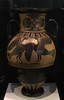
Archeology Museum with artifacts from the Greek and Roman era in Taranto.
You may be viewing yesterday's version of this page. To see the most up to date information please register for a free account.
Do not use the above information on other web sites or publications without permission of the contributor.
Nearby Images from Flickr
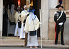
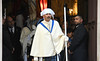


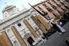
The above images may not be of the site on this page, but were taken nearby. They are loaded from Flickr so please click on them for image credits.
Click here to see more info for this site
Nearby sites
Click here to view sites on an interactive map of the areaKey: Red: member's photo, Blue: 3rd party photo, Yellow: other image, Green: no photo - please go there and take one, Grey: site destroyed
Download sites to:
KML (Google Earth)
GPX (GPS waypoints)
CSV (Garmin/Navman)
CSV (Excel)
To unlock full downloads you need to sign up as a Contributory Member. Otherwise downloads are limited to 50 sites.
Turn off the page maps and other distractions
Nearby sites listing. In the following links * = Image available
480m W 268° Taras Temple* Ancient Temple
10.7km NW 326° Leucaspide Dolmen* Burial Chamber or Dolmen
10.9km NNW 337° Accettula Dolmen* Burial Chamber or Dolmen
36.3km W 260° Tavole Palatine Temple of Hera* Ancient Temple
36.5km WSW 254° Metapontion* Ancient Village or Settlement
40.8km NNE 31° Dolmen di Montalbano* Burial Chamber or Dolmen
47.5km NNE 15° Egnazia* Ancient Village or Settlement
51.5km NNW 333° Sammichele di Bari Standing stone* Standing Stone (Menhir)
56.0km WSW 240° Siritide* Ancient Village or Settlement
57.0km WNW 292° Matera* Cave or Rock Shelter
61.0km NNW 330° Casamassima Menhir 1 Standing Stone (Menhir)
62.6km NW 318° Mercadante Menhir* Standing Stone (Menhir)
62.6km ENE 73° Via Appia (Traiana)* Ancient Trackway
63.5km SW 235° Cugno dei Vagni* Ancient Village or Settlement
65.9km E 97° Sperti Standing stone Standing Stone (Menhir)
65.9km E 96° Candido Standing Stone Standing Stone (Menhir)
68.2km E 98° Menhir di Pietragrossa Standing Stone (Menhir)
70.3km NW 305° Altamura Mura Megalitiche* Stone Fort or Dun
72.0km ESE 111° Celimanna Standing Stone Standing Stone (Menhir)
73.0km NW 309° La grotta di Lamalunga Cave or Rock Shelter
75.4km NNW 337° Menhir delle Casermette Standing Stone (Menhir)
77.6km NNW 330° Balice Menhir Standing Stone (Menhir)
78.3km ESE 103° Aia della Corte Menhir* Standing Stone (Menhir)
79.4km ESE 104° Calla a Tholos di Montalto Ancient Temple
79.9km NNW 331° Macchia Belladonna Standing stone Standing Stone (Menhir)
View more nearby sites and additional images


 We would like to know more about this location. Please feel free to add a brief description and any relevant information in your own language.
 Wir möchten mehr über diese Stätte erfahren. Bitte zögern Sie nicht, eine kurze Beschreibung und relevante Informationen in Deutsch hinzuzufügen.
 Nous aimerions en savoir encore un peu sur les lieux. S'il vous plaît n'hesitez pas à ajouter une courte description et tous les renseignements pertinents dans votre propre langue.
 Quisieramos informarnos un poco más de las lugares. No dude en añadir una breve descripción y otros datos relevantes en su propio idioma.