

<< Our Photo Pages >> Siritide - Ancient Village or Settlement in Italy in Basilicata
Submitted by Armand on Wednesday, 19 December 2018 Page Views: 808
Multi-periodSite Name: Siritide Alternative Name: Heraclea, HeracleiaCountry: Italy
NOTE: This site is 1.944 km away from the location you searched for.
Region: Basilicata Type: Ancient Village or Settlement
Nearest Town: Policoro
Latitude: 40.217360N Longitude: 16.669700E
Condition:
| 5 | Perfect |
| 4 | Almost Perfect |
| 3 | Reasonable but with some damage |
| 2 | Ruined but still recognisable as an ancient site |
| 1 | Pretty much destroyed, possibly visible as crop marks |
| 0 | No data. |
| -1 | Completely destroyed |
| 5 | Superb |
| 4 | Good |
| 3 | Ordinary |
| 2 | Not Good |
| 1 | Awful |
| 0 | No data. |
| 5 | Can be driven to, probably with disabled access |
| 4 | Short walk on a footpath |
| 3 | Requiring a bit more of a walk |
| 2 | A long walk |
| 1 | In the middle of nowhere, a nightmare to find |
| 0 | No data. |
| 5 | co-ordinates taken by GPS or official recorded co-ordinates |
| 4 | co-ordinates scaled from a detailed map |
| 3 | co-ordinates scaled from a bad map |
| 2 | co-ordinates of the nearest village |
| 1 | co-ordinates of the nearest town |
| 0 | no data |
Internal Links:
External Links:
")
The construction of the town started in 680 BCE thanks to the Greeks, who were coming from Colophon, but the town was destroyed in the 6th century BCE by the Achaean colonies in coalition with Metaponto, Crotone, and Sibari.
In 432 BCE, the town was rebuilt in the same place as before and was called Heraclea (also Heracleia or Herakleia). In very little time, it became richer and more famous than the nearby town Siris. In 280 BCE, the famous Battle of Heraclea happened there during the war between Taranto and Rome. In these places, Pyrrhus of Epirus defeated, with the help of his soldiers and elephants, Rome’s troops in a bloody battle, leading to numerous casualties in what has been called “una vittoria di Pirro” or Pyrrhus’s victory
https://en.wikipedia.org/wiki/Policoro
You may be viewing yesterday's version of this page. To see the most up to date information please register for a free account.
")
")
")
")
Do not use the above information on other web sites or publications without permission of the contributor.
Nearby Images from Flickr
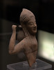
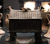
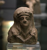
The above images may not be of the site on this page, but were taken nearby. They are loaded from Flickr so please click on them for image credits.
Click here to see more info for this site
Nearby sites
Click here to view sites on an interactive map of the areaKey: Red: member's photo, Blue: 3rd party photo, Yellow: other image, Green: no photo - please go there and take one, Grey: site destroyed
Download sites to:
KML (Google Earth)
GPX (GPS waypoints)
CSV (Garmin/Navman)
CSV (Excel)
To unlock full downloads you need to sign up as a Contributory Member. Otherwise downloads are limited to 50 sites.
Turn off the page maps and other distractions
Nearby sites listing. In the following links * = Image available
9.0km SSW 202° Cugno dei Vagni* Ancient Village or Settlement
22.7km NE 35° Metapontion* Ancient Village or Settlement
25.4km NNE 29° Tavole Palatine Temple of Hera* Ancient Temple
50.0km N 354° Matera* Cave or Rock Shelter
55.6km ENE 59° Taras Temple* Ancient Temple
56.0km ENE 59° Taranto Museo Nazionale Archeologico* Museum
56.3km NE 48° Leucaspide Dolmen* Burial Chamber or Dolmen
57.7km SSW 195° Sybaris* Ancient Village or Settlement
58.5km NE 49° Accettula Dolmen* Burial Chamber or Dolmen
69.4km N 352° Altamura Mura Megalitiche* Stone Fort or Dun
71.6km WSW 242° Grotta del Romito Cave or Rock Shelter
75.2km N 354° La grotta di Lamalunga Cave or Rock Shelter
75.5km N 5° Mercadante Menhir* Standing Stone (Menhir)
78.3km NNE 18° Sammichele di Bari Standing stone* Standing Stone (Menhir)
83.2km NNE 12° Casamassima Menhir 1 Standing Stone (Menhir)
93.0km N 352° Pietrefitte 10 Standing Stone (Menhir)
93.3km N 353° Pietrefitte 8 Standing Stone (Menhir)
93.4km N 353° Pietrefitte 9 Standing Stone (Menhir)
93.9km NE 47° Dolmen di Montalbano* Burial Chamber or Dolmen
94.0km N 353° Pietrefitte 7 Standing Stone (Menhir)
94.1km N 356° Pietrefitte 11* Standing Stone (Menhir)
94.7km N 355° Pietrefitte 12 Standing Stone (Menhir)
95.0km N 354° Pietrefitte 6 Standing Stone (Menhir)
95.3km N 354° Pietrefitte 5 Standing Stone (Menhir)
95.9km NE 39° Egnazia* Ancient Village or Settlement
View more nearby sites and additional images


 We would like to know more about this location. Please feel free to add a brief description and any relevant information in your own language.
 Wir möchten mehr über diese Stätte erfahren. Bitte zögern Sie nicht, eine kurze Beschreibung und relevante Informationen in Deutsch hinzuzufügen.
 Nous aimerions en savoir encore un peu sur les lieux. S'il vous plaît n'hesitez pas à ajouter une courte description et tous les renseignements pertinents dans votre propre langue.
 Quisieramos informarnos un poco más de las lugares. No dude en añadir una breve descripción y otros datos relevantes en su propio idioma.