


<< Our Photo Pages >> Hokuei - Stone Circle in Japan in Hokkaidō
Submitted by Aska on Sunday, 03 February 2008 Page Views: 6406
Neolithic and Bronze AgeSite Name: Hokuei Alternative Name: 北栄環状列石Country: Japan
NOTE: This site is 10.864 km away from the location you searched for.
Region: Hokkaidō Type: Stone Circle
Nearest Town: Niseko (Hokkaidō pref.) Nearest Village: Soga 曽我
Latitude: 42.828551N Longitude: 140.669160E
Condition:
| 5 | Perfect |
| 4 | Almost Perfect |
| 3 | Reasonable but with some damage |
| 2 | Ruined but still recognisable as an ancient site |
| 1 | Pretty much destroyed, possibly visible as crop marks |
| 0 | No data. |
| -1 | Completely destroyed |
| 5 | Superb |
| 4 | Good |
| 3 | Ordinary |
| 2 | Not Good |
| 1 | Awful |
| 0 | No data. |
| 5 | Can be driven to, probably with disabled access |
| 4 | Short walk on a footpath |
| 3 | Requiring a bit more of a walk |
| 2 | A long walk |
| 1 | In the middle of nowhere, a nightmare to find |
| 0 | No data. |
| 5 | co-ordinates taken by GPS or official recorded co-ordinates |
| 4 | co-ordinates scaled from a detailed map |
| 3 | co-ordinates scaled from a bad map |
| 2 | co-ordinates of the nearest village |
| 1 | co-ordinates of the nearest town |
| 0 | no data |
Internal Links:
External Links:
I have visited· I would like to visit
MAIGO has visited here
")
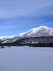
On a fine day, magnificent Mt Yōtei can be seen.
You may be viewing yesterday's version of this page. To see the most up to date information please register for a free account.
")
")
Do not use the above information on other web sites or publications without permission of the contributor.
Nearby Images from Flickr


The above images may not be of the site on this page, but were taken nearby. They are loaded from Flickr so please click on them for image credits.
Click here to see more info for this site
Nearby sites
Click here to view sites on an interactive map of the areaKey: Red: member's photo, Blue: 3rd party photo, Yellow: other image, Green: no photo - please go there and take one, Grey: site destroyed
Download sites to:
KML (Google Earth)
GPX (GPS waypoints)
CSV (Garmin/Navman)
CSV (Excel)
To unlock full downloads you need to sign up as a Contributory Member. Otherwise downloads are limited to 50 sites.
Turn off the page maps and other distractions
Nearby sites listing. In the following links * = Image available
42.7km NNE 19° NishizakiYama* Stone Circle
43.2km NNE 19° Fugoppe cave* Carving
44.3km NNE 22° ChijinYama* Stone Circle
44.5km NNE 22° Oshoro* Stone Circle
50.6km NNE 32° Temiya cave* Carving
52.6km NNE 31° ex-Aoyama Bettei residence* Modern Stone Circle etc
57.5km E 79° Makomanai Takino-Reien cemetery* Modern Stone Circle etc
76.0km ENE 65° Ebetsu Kofungun* Round Barrow(s)
76.2km ENE 65° Ebetsu Chashi* Hillfort
80.1km S 188° Washi-no-ki* Stone Circle
85.6km E 85° Kiusu* Henge
128.1km NE 53° Hokkaidō Children's Land* Modern Stone Circle etc
145.1km NE 49° Otoe* Stone Circle
147.8km ENE 61° Nokanan henge* Henge
150.0km ESE 111° Hoinasir Chashi* Hillfort
150.2km ESE 111° Sibecar Chashi* Hillfort
150.7km ESE 109° Mena Chashi* Hillfort
159.1km NE 51° Kamui-Kotan stone circle* Stone Circle
162.0km SSW 197° Hōgen-ji temple (in Hokkaidō)* Modern Stone Circle etc
162.0km SSW 197° Hōdō-ji temple* Modern Stone Circle etc
162.1km SSW 197° Kōzen-ji temple (in Hokkaidō)* Modern Stone Circle etc
217.9km S 187° Kamegaoka* Ancient Village or Settlement
224.3km S 179° Sannai Maruyama* Ancient Village or Settlement
232.6km S 179° Komakino* Stone Circle
238.2km S 186° Ōmori Katsuyama* Stone Circle
View more nearby sites and additional images


 We would like to know more about this location. Please feel free to add a brief description and any relevant information in your own language.
 Wir möchten mehr über diese Stätte erfahren. Bitte zögern Sie nicht, eine kurze Beschreibung und relevante Informationen in Deutsch hinzuzufügen.
 Nous aimerions en savoir encore un peu sur les lieux. S'il vous plaît n'hesitez pas à ajouter une courte description et tous les renseignements pertinents dans votre propre langue.
 Quisieramos informarnos un poco más de las lugares. No dude en añadir una breve descripción y otros datos relevantes en su propio idioma.