


<< Our Photo Pages >> Tennichigū - Cairn in Japan in Honshū
Submitted by Aska on Tuesday, 01 September 2009 Page Views: 3930
Multi-periodSite Name: Tennichigū Alternative Name: Tennichigu, 天日宮, AmenohinomiyaCountry: Japan
NOTE: This site is 8.546 km away from the location you searched for.
Region: Honshū Type: Cairn
Nearest Town: Daisen (Akita pref.) Nearest Village: Kyōwa-Sakai 協和境
Latitude: 39.610380N Longitude: 140.321240E
Condition:
| 5 | Perfect |
| 4 | Almost Perfect |
| 3 | Reasonable but with some damage |
| 2 | Ruined but still recognisable as an ancient site |
| 1 | Pretty much destroyed, possibly visible as crop marks |
| 0 | No data. |
| -1 | Completely destroyed |
| 5 | Superb |
| 4 | Good |
| 3 | Ordinary |
| 2 | Not Good |
| 1 | Awful |
| 0 | No data. |
| 5 | Can be driven to, probably with disabled access |
| 4 | Short walk on a footpath |
| 3 | Requiring a bit more of a walk |
| 2 | A long walk |
| 1 | In the middle of nowhere, a nightmare to find |
| 0 | No data. |
| 5 | co-ordinates taken by GPS or official recorded co-ordinates |
| 4 | co-ordinates scaled from a detailed map |
| 3 | co-ordinates scaled from a bad map |
| 2 | co-ordinates of the nearest village |
| 1 | co-ordinates of the nearest town |
| 0 | no data |
Internal Links:
External Links:
I have visited· I would like to visit
eirrac5 would like to visit
")
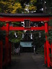
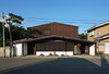
In the precinct of Karamatsu Jinja (唐松神社) shrine, another strange shrine hides. The shrine stands on a cairn island in a circle pond and all the precinct is covered with pebbles.
You may be viewing yesterday's version of this page. To see the most up to date information please register for a free account.
Do not use the above information on other web sites or publications without permission of the contributor.
Nearby Images from Flickr

The above images may not be of the site on this page, but were taken nearby. They are loaded from Flickr so please click on them for image credits.
Click here to see more info for this site
Nearby sites
Click here to view sites on an interactive map of the areaKey: Red: member's photo, Blue: 3rd party photo, Yellow: other image, Green: no photo - please go there and take one, Grey: site destroyed
Download sites to:
KML (Google Earth)
GPX (GPS waypoints)
CSV (Garmin/Navman)
CSV (Excel)
To unlock full downloads you need to sign up as a Contributory Member. Otherwise downloads are limited to 50 sites.
Turn off the page maps and other distractions
Nearby sites listing. In the following links * = Image available
20.7km E 94° Kakunodate samurai residences* Modern Stone Circle etc
25.0km NW 305° Akita-jō* Ancient Village or Settlement
25.3km SE 129° Hotta-no Saku* Ancient Village or Settlement
37.5km N 10° Sakeishi (in Nekko)* Carving
44.9km SSW 200° Sakeishi (in Yashima)* Carving
45.4km ESE 122° Uchinosawa* Stone Circle
55.6km WNW 300° Tsunami stone (at Shiosezaki cape)* Natural Stone / Erratic / Other Natural Feature
62.8km S 173° Sakeishi (in Innai)* Carving
65.7km N 2° Isedōtai* Stone Circle
66.0km ENE 58° Kamaishi* Stone Circle
67.7km E 83° Shiwa-jō* Ancient Village or Settlement
69.1km ENE 74° Yubunezawa* Stone Circle
72.2km E 81° Mitsuishi Jinja shrine* Natural Stone / Erratic / Other Natural Feature
72.9km E 90° Tokutan-jō* Ancient Village or Settlement
74.6km ESE 118° Ezuriko Kofungun* Chambered Cairn
78.9km NNE 29° Takaya-date* Ancient Village or Settlement
80.2km SSW 206° Kiwa-no Saku* Ancient Village or Settlement
80.8km ESE 120° Kabayama* Stone Circle
84.3km NNE 29° Ōyu* Stone Circle
87.8km SSW 208° Homma Bijutsukan museum of art* Modern Stone Circle etc
88.9km NNE 24° Kosaka* Stone Circle
96.9km SE 135° Mōtsū-ji temple* Modern Stone Circle etc
101.4km ESE 107° Tsuzukiishi* Natural Stone / Erratic / Other Natural Feature
106.8km NE 52° Goshono* Ancient Village or Settlement
111.5km N 6° Hirosaki-jō castle San-no-Maru* Modern Stone Circle etc
View more nearby sites and additional images


 We would like to know more about this location. Please feel free to add a brief description and any relevant information in your own language.
 Wir möchten mehr über diese Stätte erfahren. Bitte zögern Sie nicht, eine kurze Beschreibung und relevante Informationen in Deutsch hinzuzufügen.
 Nous aimerions en savoir encore un peu sur les lieux. S'il vous plaît n'hesitez pas à ajouter une courte description et tous les renseignements pertinents dans votre propre langue.
 Quisieramos informarnos un poco más de las lugares. No dude en añadir una breve descripción y otros datos relevantes en su propio idioma.