


<< Our Photo Pages >> Ōmuro Kofungun (in Gunma) - Passage Grave in Japan
Submitted by Aska on Thursday, 08 February 2024 Page Views: 2584
Iron Age and Later PrehistorySite Name: Ōmuro Kofungun (in Gunma) Alternative Name: 大室古墳群, Shō-Futagozuka Kofun (小双子塚古墳=small twin-mound tumulus)Country: Japan
NOTE: This site is 10.381 km away from the location you searched for.
Type: Passage Grave
Nearest Town: Maebashi (Gunma pref.) Nearest Village: NishiŌmuro-machi 西大
Latitude: 36.389600N Longitude: 139.193800E
Condition:
| 5 | Perfect |
| 4 | Almost Perfect |
| 3 | Reasonable but with some damage |
| 2 | Ruined but still recognisable as an ancient site |
| 1 | Pretty much destroyed, possibly visible as crop marks |
| 0 | No data. |
| -1 | Completely destroyed |
| 5 | Superb |
| 4 | Good |
| 3 | Ordinary |
| 2 | Not Good |
| 1 | Awful |
| 0 | No data. |
| 5 | Can be driven to, probably with disabled access |
| 4 | Short walk on a footpath |
| 3 | Requiring a bit more of a walk |
| 2 | A long walk |
| 1 | In the middle of nowhere, a nightmare to find |
| 0 | No data. |
| 5 | co-ordinates taken by GPS or official recorded co-ordinates |
| 4 | co-ordinates scaled from a detailed map |
| 3 | co-ordinates scaled from a bad map |
| 2 | co-ordinates of the nearest village |
| 1 | co-ordinates of the nearest town |
| 0 | no data |
Internal Links:
External Links:
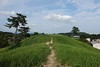
 (PID:112496)")
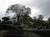
The park also contains modern stone settings and a reconstructed wooden house in old Japanese style.
Ōmuro Kōen information in English. (archive link)
You may be viewing yesterday's version of this page. To see the most up to date information please register for a free account.
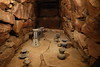
 (PID:112497)")
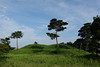
 (PID:112495)")
 (PID:112494)")
Do not use the above information on other web sites or publications without permission of the contributor.
Nearby Images from Flickr
![IMGP9183_4_5_hdr[3]](https://farm3.static.flickr.com/2616/3867658892_89018cbb68_t.jpg)
The above images may not be of the site on this page, but were taken nearby. They are loaded from Flickr so please click on them for image credits.
Click here to see more info for this site
Nearby sites
Click here to view sites on an interactive map of the areaKey: Red: member's photo, Blue: 3rd party photo, Yellow: other image, Green: no photo - please go there and take one, Grey: site destroyed
Download sites to:
KML (Google Earth)
GPX (GPS waypoints)
CSV (Garmin/Navman)
CSV (Excel)
To unlock full downloads you need to sign up as a Contributory Member. Otherwise downloads are limited to 50 sites.
Turn off the page maps and other distractions
Nearby sites listing. In the following links * = Image available
5.8km NE 49° Takei Haiji* Not Known (by us)
12.6km W 273° Ōyama Kofun* Chambered Cairn
13.1km ENE 58° Hōtoku-ji temple* Modern Stone Circle etc
15.9km WNW 289° Mitsuya Kofun* Passage Grave
18.6km W 267° Hodota Hachimanzuka Kofun* Long Barrow
19.1km E 94° Itakura Jinja shrine* Standing Stone (Menhir)
19.4km SW 230° Yama-no-Ue Kofun* Passage Grave
19.5km SW 225° Isezuka Kofun* Passage Grave
22.2km W 261° Inarimori* Chambered Cairn
23.2km NW 309° Kanai Higashiura* Ancient Village or Settlement
23.6km ESE 119° Tsukamawari Kofun* Long Barrow
23.6km NW 306° Kanai Kofun* Passage Grave
25.2km SW 230° Ipponsugi Kofun* Passage Grave
29.7km SSE 153° Miyazuka Kofun* Passage Grave
30.4km NW 319° Gunma Astronomical Observatory* Modern Stone Circle etc
38.0km SE 136° Hachiman-yama Kofun* Passage Grave
38.6km SE 138° Sakitama Kofungun* Passage Grave
39.1km NNW 331° Yaze* Ancient Village or Settlement
42.8km W 265° Sakamoto-Kitaura* Stone Circle
43.9km SSE 152° Yoshimi Hyakuana* Rock Cut Tomb
49.7km SSE 164° Ōrui Kofungun* Chambered Cairn
54.5km NE 41° Taiyū-in shrine* Modern Stone Circle etc
56.1km SSE 168° Shōden-in temple* Modern Stone Circle etc
57.1km W 262° Mozawa Minami-Ishidō* Stone Circle
59.5km SSE 156° Sannōzuka Kofun* Passage Grave
View more nearby sites and additional images


 We would like to know more about this location. Please feel free to add a brief description and any relevant information in your own language.
 Wir möchten mehr über diese Stätte erfahren. Bitte zögern Sie nicht, eine kurze Beschreibung und relevante Informationen in Deutsch hinzuzufügen.
 Nous aimerions en savoir encore un peu sur les lieux. S'il vous plaît n'hesitez pas à ajouter une courte description et tous les renseignements pertinents dans votre propre langue.
 Quisieramos informarnos un poco más de las lugares. No dude en añadir una breve descripción y otros datos relevantes en su propio idioma.