


<< Our Photo Pages >> JA Nansun - Modern Stone Circle etc in Japan in Honshū
Submitted by Aska on Sunday, 27 February 2011 Page Views: 2880
Modern SitesSite Name: JA Nansun Alternative Name: JA南駿Country: Japan
NOTE: This site is 5.815 km away from the location you searched for.
Region: Honshū Type: Modern Stone Circle etc
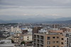
Nearest Town: Numazu (Shizuoka pref.) Nearest Village: Shimokanuki 下香貫
Latitude: 35.083320N Longitude: 138.869430E
Condition:
| 5 | Perfect |
| 4 | Almost Perfect |
| 3 | Reasonable but with some damage |
| 2 | Ruined but still recognisable as an ancient site |
| 1 | Pretty much destroyed, possibly visible as crop marks |
| 0 | No data. |
| -1 | Completely destroyed |
| 5 | Superb |
| 4 | Good |
| 3 | Ordinary |
| 2 | Not Good |
| 1 | Awful |
| 0 | No data. |
| 5 | Can be driven to, probably with disabled access |
| 4 | Short walk on a footpath |
| 3 | Requiring a bit more of a walk |
| 2 | A long walk |
| 1 | In the middle of nowhere, a nightmare to find |
| 0 | No data. |
| 5 | co-ordinates taken by GPS or official recorded co-ordinates |
| 4 | co-ordinates scaled from a detailed map |
| 3 | co-ordinates scaled from a bad map |
| 2 | co-ordinates of the nearest village |
| 1 | co-ordinates of the nearest town |
| 0 | no data |
Internal Links:
External Links:
")
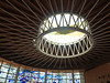
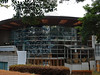
In front of the building of JA (Japan Agricultural Cooperatives) Nansun branch, a stone monument which looks like the stone circle of Dōgaya.
You may be viewing yesterday's version of this page. To see the most up to date information please register for a free account.
Do not use the above information on other web sites or publications without permission of the contributor.
Nearby Images from Flickr
The above images may not be of the site on this page, but were taken nearby. They are loaded from Flickr so please click on them for image credits.
Click here to see more info for this site
Nearby sites
Click here to view sites on an interactive map of the areaKey: Red: member's photo, Blue: 3rd party photo, Yellow: other image, Green: no photo - please go there and take one, Grey: site destroyed
Download sites to:
KML (Google Earth)
GPX (GPS waypoints)
CSV (Garmin/Navman)
CSV (Excel)
To unlock full downloads you need to sign up as a Contributory Member. Otherwise downloads are limited to 50 sites.
Turn off the page maps and other distractions
Nearby sites listing. In the following links * = Image available
1.8km N 357° Tama-Toishi* Polissoir
7.9km N 354° Shimizu Yanagikita Kofun* Passage Grave
8.3km E 90° Kashiya-no Hyakketsu* Rock Cut Tomb
8.5km E 82° Yōtoku-ji temple* Standing Stones
12.3km WNW 298° Kōshinzuka Kofun* Passage Grave
16.9km SE 142° KamiShiroiwa* Stone Circle
26.8km NE 52° Sōun-ji temple* Modern Stone Circle etc
32.7km W 263° Seiken-ji temple* Modern Stone Circle etc
35.8km NW 310° Sengo* Stone Circle
38.6km NE 42° Kanekodai* Stone Circle
40.0km NE 54° Haneo Yokoana* Rock Cut Tomb
43.3km NE 53° Dainichigakubo Yokoana* Rock Cut Tomb
44.3km WSW 252° Toro Iseki* Ancient Village or Settlement
44.7km NE 54° Tarekoyato-nishi Yokoana* Rock Cut Tomb
45.0km S 189° Iwakura Kofungun* Chambered Cairn
46.0km NE 56° Shōgakubo Yokoana* Rock Cut Tomb
46.1km WSW 258° Rinsai-ji temple* Modern Stone Circle etc
47.2km NE 55° Manda Miyanoiri Yokoana* Rock Cut Tomb
50.9km WSW 254° Saioku-ji temple* Modern Stone Circle etc
51.7km NE 47° Sannomiya-Shimoyato* Stone Circle
57.7km N 358° Oni-no Tateishi* Standing Stone (Menhir)
58.1km NE 56° Koshinoyama Yokoana* Rock Cut Tomb
60.1km N 8° Oni-no Tsue* Standing Stone (Menhir)
62.2km NNW 333° Ōzuka Kofun (in Yamanashi)* Long Barrow
64.2km NNW 344° Kyōzuka Kofun (in Yamanashi)* Passage Grave
View more nearby sites and additional images


 We would like to know more about this location. Please feel free to add a brief description and any relevant information in your own language.
 Wir möchten mehr über diese Stätte erfahren. Bitte zögern Sie nicht, eine kurze Beschreibung und relevante Informationen in Deutsch hinzuzufügen.
 Nous aimerions en savoir encore un peu sur les lieux. S'il vous plaît n'hesitez pas à ajouter une courte description et tous les renseignements pertinents dans votre propre langue.
 Quisieramos informarnos un poco más de las lugares. No dude en añadir una breve descripción y otros datos relevantes en su propio idioma.