

<< Our Photo Pages >> Togariishi - Ancient Village or Settlement in Japan in Honshū
Submitted by Aska on Tuesday, 11 September 2012 Page Views: 2656
Neolithic and Bronze AgeSite Name: Togariishi Alternative Name: 尖石遺跡Country: Japan
NOTE: This site is 11.575 km away from the location you searched for.
Region: Honshū Type: Ancient Village or Settlement
Nearest Town: Chino (Nagano pref.) Nearest Village: Toyohira 豊平
Latitude: 36.012420N Longitude: 138.232210E
Condition:
| 5 | Perfect |
| 4 | Almost Perfect |
| 3 | Reasonable but with some damage |
| 2 | Ruined but still recognisable as an ancient site |
| 1 | Pretty much destroyed, possibly visible as crop marks |
| 0 | No data. |
| -1 | Completely destroyed |
| 5 | Superb |
| 4 | Good |
| 3 | Ordinary |
| 2 | Not Good |
| 1 | Awful |
| 0 | No data. |
| 5 | Can be driven to, probably with disabled access |
| 4 | Short walk on a footpath |
| 3 | Requiring a bit more of a walk |
| 2 | A long walk |
| 1 | In the middle of nowhere, a nightmare to find |
| 0 | No data. |
| 5 | co-ordinates taken by GPS or official recorded co-ordinates |
| 4 | co-ordinates scaled from a detailed map |
| 3 | co-ordinates scaled from a bad map |
| 2 | co-ordinates of the nearest village |
| 1 | co-ordinates of the nearest town |
| 0 | no data |
Internal Links:
External Links:
")
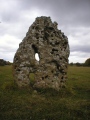
A fireplace in a ruin of a residence is reconstructed like a stone circle (36.01294N,138.23259E). A neighbouring commune Yosuke-one (与助尾根遺跡, 36.01454N,138.23308E) is reconstructed as it was. A symbol stone, called Hijiri-ishi (=Sacred stone 聖石, 36.02834N,138.23965E), of another commune was discovered 3km away from here.
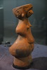
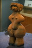
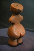
A museum which exhibits a clay figure called Jōmon Venus is attached. Open 9:00-16:30, closed on Mondays and the days around the New Years Day. Admission 500 Japanese Yen.
Museum's official site (in English)
You may be viewing yesterday's version of this page. To see the most up to date information please register for a free account.
Do not use the above information on other web sites or publications without permission of the contributor.
Nearby Images from Flickr


The above images may not be of the site on this page, but were taken nearby. They are loaded from Flickr so please click on them for image credits.
Click here to see more info for this site
Nearby sites
Click here to view sites on an interactive map of the areaKey: Red: member's photo, Blue: 3rd party photo, Yellow: other image, Green: no photo - please go there and take one, Grey: site destroyed
Download sites to:
KML (Google Earth)
GPX (GPS waypoints)
CSV (Garmin/Navman)
CSV (Excel)
To unlock full downloads you need to sign up as a Contributory Member. Otherwise downloads are limited to 50 sites.
Turn off the page maps and other distractions
Nearby sites listing. In the following links * = Image available
9.6km SSE 164° Tsubodaira* Burial Chamber or Dolmen
15.5km SSE 165° Mukōhara* Stone Circle
15.6km WNW 300° Manji-no Sekibutsu* Sculptured Stone
22.0km SSW 213° Onshō-ji temple* Modern Stone Circle etc
22.9km SE 143° Kinsei* Stone Circle
25.3km WNW 294° Shiojiri Honjin* Modern Stone Circle etc
25.9km SSE 155° Mumei-no Daisekitō* Modern Stone Circle etc
27.7km NE 52° Kitazawa* Standing Stone (Menhir)
28.3km WSW 248° Ina Baien plum orchard* Modern Stone Circle etc
32.1km NW 320° Harizuka Kofun* Chambered Cairn
41.8km SSE 148° Myōzen-ji temple* Modern Stone Circle etc
43.0km NW 316° Honmura-no-Jindaimoji-hi* Carving
43.4km N 353° Jingū-ji Kofun* Passage Grave
45.2km NE 41° Mozawa Minami-Ishidō* Stone Circle
45.4km SE 141° Otengusan Kofun* Chambered Cairn
46.2km SE 142° Ōhira Kofungun* Chambered Cairn
46.9km SE 142° Yumurayama Kofungun* Chambered Cairn
49.9km SE 140° Tōkō-ji temple* Modern Stone Circle etc
50.1km NNW 343° Azaka Nakamura Kofun* Chambered Cairn
50.1km NNW 344° Azaka Shōgunzuka Kofun* Chambered Cairn
50.3km ESE 123° Somaguchi* Standing Stone (Menhir)
50.8km NNW 342° Oisawa Kofungun* Chambered Cairn
51.4km SE 138° Yokone Sakurai Kofungun* Chambered Cairn
52.0km NNW 341° Kanorizuka Kofun* Chambered Cairn
52.5km SE 133° Eian-ji temple* Modern Stone Circle etc
View more nearby sites and additional images


 We would like to know more about this location. Please feel free to add a brief description and any relevant information in your own language.
 Wir möchten mehr über diese Stätte erfahren. Bitte zögern Sie nicht, eine kurze Beschreibung und relevante Informationen in Deutsch hinzuzufügen.
 Nous aimerions en savoir encore un peu sur les lieux. S'il vous plaît n'hesitez pas à ajouter une courte description et tous les renseignements pertinents dans votre propre langue.
 Quisieramos informarnos un poco más de las lugares. No dude en añadir una breve descripción y otros datos relevantes en su propio idioma.