 with our Megalithic Portal iPhone app")
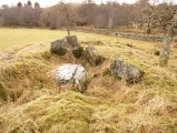

<< Our Photo Pages >> Ishio Jinja shrine - Stone Row / Alignment in Japan in Shikoku
Submitted by Aska on Sunday, 24 February 2008 Page Views: 4440
Early Medieval (Dark Age)Site Name: Ishio Jinja shrine Alternative Name: 石尾神社, 石堂はん Ishidō-han Ishido-hanCountry: Japan
NOTE: This site is 47.071 km away from the location you searched for.
Region: Shikoku Type: Stone Row / Alignment
Nearest Town: Mima (Tokushima pref.) Nearest Village: Anabukichō-Furumiya 穴吹
Latitude: 33.937973N Longitude: 134.153000E
Condition:
| 5 | Perfect |
| 4 | Almost Perfect |
| 3 | Reasonable but with some damage |
| 2 | Ruined but still recognisable as an ancient site |
| 1 | Pretty much destroyed, possibly visible as crop marks |
| 0 | No data. |
| -1 | Completely destroyed |
| 5 | Superb |
| 4 | Good |
| 3 | Ordinary |
| 2 | Not Good |
| 1 | Awful |
| 0 | No data. |
| 5 | Can be driven to, probably with disabled access |
| 4 | Short walk on a footpath |
| 3 | Requiring a bit more of a walk |
| 2 | A long walk |
| 1 | In the middle of nowhere, a nightmare to find |
| 0 | No data. |
| 5 | co-ordinates taken by GPS or official recorded co-ordinates |
| 4 | co-ordinates scaled from a detailed map |
| 3 | co-ordinates scaled from a bad map |
| 2 | co-ordinates of the nearest village |
| 1 | co-ordinates of the nearest town |
| 0 | no data |
Internal Links:
External Links:
I have visited· I would like to visit
rrmoser would like to visit
")
A shinto shrine in the deep mountain wood. The uninhibited wooden shrine building is simple and tiny, but the sacred area consists of a huge rising rock and the enigmatic standing stone rows. These setting may be the prototype of shinto sanctuary.
You may be viewing yesterday's version of this page. To see the most up to date information please register for a free account.
")
")
")
")
")
Do not use the above information on other web sites or publications without permission of the contributor.
Click here to see more info for this site
Nearby sites
Click here to view sites on an interactive map of the areaKey: Red: member's photo, Blue: 3rd party photo, Yellow: other image, Green: no photo - please go there and take one, Grey: site destroyed
Download sites to:
KML (Google Earth)
GPX (GPS waypoints)
CSV (Garmin/Navman)
CSV (Excel)
To unlock full downloads you need to sign up as a Contributory Member. Otherwise downloads are limited to 50 sites.
Turn off the page maps and other distractions
Nearby sites listing. In the following links * = Image available
7.0km N 358° Shichijinseki* Stone Row / Alignment
7.5km N 358° Tagata* Standing Stones
7.5km NW 319° Chichibushan Taki* Stone Row / Alignment
7.6km N 357° Shinmei Jinja shrine* Misc. Earthwork
7.7km N 359° Shirahito Jinja-no Shishiseki* Standing Stones
8.8km NNW 340° Shinō* Stone Row / Alignment
9.2km N 1° Maruyama Hachiman Jinja shrine* Standing Stones
9.7km NW 321° Tateishiyama* Stone Row / Alignment
9.7km NW 310° Kiradō* Standing Stones
9.8km NNW 343° Fuchimyō* Standing Stone (Menhir)
11.6km N 3° Hirano-no Tateishi* Standing Stones
12.0km NE 41° Kamisuki Jinja shrine* Standing Stone (Menhir)
12.6km NW 323° Ōizumi-dō* Standing Stone (Menhir)
12.8km NE 48° Ofunattsan* Misc. Earthwork
13.2km NE 49° Yambashira* Standing Stones
13.7km NW 323° Higashiura* Standing Stone (Menhir)
13.7km NW 322° Nagai Family Residence garden* Modern Stone Circle etc
13.9km NW 312° Dōmekidō* Standing Stones
14.0km NE 37° Akaiwa Shōgen* Misc. Earthwork
14.1km NE 40° Hakeishi* Standing Stone (Menhir)
14.4km NW 321° Nishiyama Kofun (in Tokushima)* Standing Stone (Menhir)
14.6km NE 43° Nara-no-ki* Standing Stone (Menhir)
15.0km N 357° Tōrin-ji temple* Modern Stone Circle etc
15.3km NW 326° Ganshō-ji temple* Modern Stone Circle etc
15.4km NNE 33° Aogi-no Dankonseki* Standing Stones
View more nearby sites and additional images


 We would like to know more about this location. Please feel free to add a brief description and any relevant information in your own language.
 Wir möchten mehr über diese Stätte erfahren. Bitte zögern Sie nicht, eine kurze Beschreibung und relevante Informationen in Deutsch hinzuzufügen.
 Nous aimerions en savoir encore un peu sur les lieux. S'il vous plaît n'hesitez pas à ajouter une courte description et tous les renseignements pertinents dans votre propre langue.
 Quisieramos informarnos un poco más de las lugares. No dude en añadir una breve descripción y otros datos relevantes en su propio idioma.