


<< Our Photo Pages >> Okyaku Yashiki - Modern Stone Circle etc in Japan in Kyūshū
Submitted by Aska on Saturday, 04 April 2020 Page Views: 434
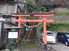
Modern SitesSite Name: Okyaku Yashiki Alternative Name: 御客屋敷 月鐘楼 Gesshōrō, GesshoroCountry: Japan
NOTE: This site is 9.906 km away from the location you searched for.
Region: Kyūshū Type: Modern Stone Circle etc
Nearest Town: Taketa (Ōita prefecture) Nearest Village: Taketa-machi 竹田
Latitude: 32.967910N Longitude: 131.391860E
Condition:
| 5 | Perfect |
| 4 | Almost Perfect |
| 3 | Reasonable but with some damage |
| 2 | Ruined but still recognisable as an ancient site |
| 1 | Pretty much destroyed, possibly visible as crop marks |
| 0 | No data. |
| -1 | Completely destroyed |
| 5 | Superb |
| 4 | Good |
| 3 | Ordinary |
| 2 | Not Good |
| 1 | Awful |
| 0 | No data. |
| 5 | Can be driven to, probably with disabled access |
| 4 | Short walk on a footpath |
| 3 | Requiring a bit more of a walk |
| 2 | A long walk |
| 1 | In the middle of nowhere, a nightmare to find |
| 0 | No data. |
| 5 | co-ordinates taken by GPS or official recorded co-ordinates |
| 4 | co-ordinates scaled from a detailed map |
| 3 | co-ordinates scaled from a bad map |
| 2 | co-ordinates of the nearest village |
| 1 | co-ordinates of the nearest town |
| 0 | no data |
Internal Links:
External Links:
")
Open 11:00-17:00, closed on Wednesday and Thursday
You may be viewing yesterday's version of this page. To see the most up to date information please register for a free account.
Do not use the above information on other web sites or publications without permission of the contributor.
Nearby Images from Flickr

The above images may not be of the site on this page, but were taken nearby. They are loaded from Flickr so please click on them for image credits.
Click here to see more info for this site
Nearby sites
Click here to view sites on an interactive map of the areaKey: Red: member's photo, Blue: 3rd party photo, Yellow: other image, Green: no photo - please go there and take one, Grey: site destroyed
Download sites to:
KML (Google Earth)
GPX (GPS waypoints)
CSV (Garmin/Navman)
CSV (Excel)
To unlock full downloads you need to sign up as a Contributory Member. Otherwise downloads are limited to 50 sites.
Turn off the page maps and other distractions
Nearby sites listing. In the following links * = Image available
872m ENE 60° Hekiun-ji temple* Modern Stone Circle etc
35.6km NE 39° Takio Hyakketsu* Rock Cut Tomb
37.9km N 2° Tsukumozuka* Artificial Mound
41.6km ENE 64° Shimoyama Kofun* Sculptured Stone
41.6km ENE 62° Usuzuka Kofun* Sculptured Stone
43.3km NNW 330° Kurushima Family Residence garden* Modern Stone Circle etc
48.2km W 265° Mutabaru* Stone Circle
48.7km W 269° Kokan-yama* Burial Chamber or Dolmen
49.0km W 268° Fujio* Burial Chamber or Dolmen
49.7km SSE 151° Noji* Sculptured Stone
49.9km SSE 149° Nobeoka Castle* Modern Stone Circle etc
50.4km W 273° Hiraraishi* Burial Chamber or Dolmen
52.5km NNE 16° Fujiwara ōishi* Burial Chamber or Dolmen
52.7km N 7° Shimoyama* Stone Circle
52.9km N 356° Shimoichi Hyakketsu* Rock Cut Tomb
53.0km N 356° Sanmyō Jinja shrine* Standing Stones
53.3km N 2° Hakusan Jinja shrine* Stone Circle
54.3km NNE 23° Ōhara Family residence garden* Modern Stone Circle etc
54.4km N 0° Sada-no-Kyōishi* Standing Stones
54.9km N 1° Komekami-yama* Stone Circle
55.1km N 360° Koshiki-iwa* Standing Stone (Menhir)
55.9km W 271° Otodo* Burial Chamber or Dolmen
56.1km W 265° Ishinomoto* Burial Chamber or Dolmen
56.2km W 274° Kukuchi-no-ki* Hillfort
57.1km WSW 257° Umenoki* Burial Chamber or Dolmen
View more nearby sites and additional images


 We would like to know more about this location. Please feel free to add a brief description and any relevant information in your own language.
 Wir möchten mehr über diese Stätte erfahren. Bitte zögern Sie nicht, eine kurze Beschreibung und relevante Informationen in Deutsch hinzuzufügen.
 Nous aimerions en savoir encore un peu sur les lieux. S'il vous plaît n'hesitez pas à ajouter une courte description et tous les renseignements pertinents dans votre propre langue.
 Quisieramos informarnos un poco más de las lugares. No dude en añadir una breve descripción y otros datos relevantes en su propio idioma.