


<< Our Photo Pages >> Shinfukada - Chambered Cairn in Japan in Kyūshū
Submitted by Aska on Thursday, 11 February 2010 Page Views: 2724
Neolithic and Bronze AgeSite Name: Shinfukada Alternative Name: 新深田Country: Japan
NOTE: This site is 12.313 km away from the location you searched for.
Region: Kyūshū Type: Chambered Cairn
Nearest Town: Asagiri-chō (Kumamoto pref.) Nearest Village: Fukada-Nishi 深田西
Latitude: 32.262820N Longitude: 130.850770E
Condition:
| 5 | Perfect |
| 4 | Almost Perfect |
| 3 | Reasonable but with some damage |
| 2 | Ruined but still recognisable as an ancient site |
| 1 | Pretty much destroyed, possibly visible as crop marks |
| 0 | No data. |
| -1 | Completely destroyed |
| 5 | Superb |
| 4 | Good |
| 3 | Ordinary |
| 2 | Not Good |
| 1 | Awful |
| 0 | No data. |
| 5 | Can be driven to, probably with disabled access |
| 4 | Short walk on a footpath |
| 3 | Requiring a bit more of a walk |
| 2 | A long walk |
| 1 | In the middle of nowhere, a nightmare to find |
| 0 | No data. |
| 5 | co-ordinates taken by GPS or official recorded co-ordinates |
| 4 | co-ordinates scaled from a detailed map |
| 3 | co-ordinates scaled from a bad map |
| 2 | co-ordinates of the nearest village |
| 1 | co-ordinates of the nearest town |
| 0 | no data |
Internal Links:
External Links:
")
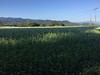
An example of the northern advance (Kumamoto Prefecture) of the rock-tile roofed burial pits, which are common in the north from Kagoshima Prefecture. 9 mounds on a isolated hill in a sweet potato field were excavated by the students and teachers of a high school nearby.
You may be viewing yesterday's version of this page. To see the most up to date information please register for a free account.
Do not use the above information on other web sites or publications without permission of the contributor.
Nearby Images from Flickr

The above images may not be of the site on this page, but were taken nearby. They are loaded from Flickr so please click on them for image credits.
Click here to see more info for this site
Nearby sites
Click here to view sites on an interactive map of the areaKey: Red: member's photo, Blue: 3rd party photo, Yellow: other image, Green: no photo - please go there and take one, Grey: site destroyed
Download sites to:
KML (Google Earth)
GPX (GPS waypoints)
CSV (Garmin/Navman)
CSV (Excel)
To unlock full downloads you need to sign up as a Contributory Member. Otherwise downloads are limited to 50 sites.
Turn off the page maps and other distractions
Nearby sites listing. In the following links * = Image available
8.1km SW 216° Kyōgamine* Rock Cut Tomb
10.5km WSW 241° Ōmura* Rock Cut Tomb
24.5km SSW 195° Shimauchi underground tunnel tombs* Not Known (by us)
31.2km SSE 153° HigashiNiwara underground tunnel tombs* Not Known (by us)
31.3km SSW 199° Nagayama* Chambered Cairn
37.0km SW 223° Uzun Kofungun* Chambered Cairn
39.8km W 262° Hatsuno* Chambered Cairn
46.4km SW 217° Byūbaru* Chambered Cairn
50.4km WNW 289° Miyazaki cists* Cist
53.9km ESE 108° Saitobaru Kofungun* Long Barrow
59.0km S 191° Hayato-zuka* Ancient Temple
61.2km NNW 346° Kitaoka Park* Modern Stone Circle etc
61.7km SW 217° Sannōdake* Stone Circle
61.9km NNW 347° Kumamoto Castle* Modern Stone Circle etc
62.1km NNW 347° Kumamoto Kenritsu Bijutsukan art gallery* Museum
62.4km NNW 347° Hosokawa-Gyōbu Family Residence garden* Modern Stone Circle etc
65.2km WSW 257° Kasedō Kofun* Chambered Cairn
65.2km WNW 292° Tsuma-no-hana* Chambered Cairn
65.3km WSW 258° Komukae* Chambered Cairn
66.0km N 356° Umenoki* Burial Chamber or Dolmen
66.7km NW 311° Nishi-Onzuka* Burial Chamber or Dolmen
67.4km NW 311° Kumano Sekijin* Sculptured Stone
67.5km NW 311° Enokida Sekijin* Sculptured Stone
68.0km E 90° Tsuno Kofungun* Chambered Cairn
68.1km NW 314° Kiba Resseki-Suimon* Hillfort
View more nearby sites and additional images


 We would like to know more about this location. Please feel free to add a brief description and any relevant information in your own language.
 Wir möchten mehr über diese Stätte erfahren. Bitte zögern Sie nicht, eine kurze Beschreibung und relevante Informationen in Deutsch hinzuzufügen.
 Nous aimerions en savoir encore un peu sur les lieux. S'il vous plaît n'hesitez pas à ajouter une courte description et tous les renseignements pertinents dans votre propre langue.
 Quisieramos informarnos un poco más de las lugares. No dude en añadir una breve descripción y otros datos relevantes en su propio idioma.