


<< Our Photo Pages >> Kōkadani Kofun - Passage Grave in Japan in Kyūshū
Submitted by Aska on Monday, 28 July 2008 Page Views: 3898
Rock ArtSite Name: Kōkadani Kofun Alternative Name: 弘化谷古墳 Kokadani KofunCountry: Japan
NOTE: This site is 2.478 km away from the location you searched for.
Region: Kyūshū Type: Passage Grave
Nearest Town: Hirokawa-machi (Fukuoka pref.) Nearest Village: Ōta 太田
Latitude: 33.236410N Longitude: 130.519730E
Condition:
| 5 | Perfect |
| 4 | Almost Perfect |
| 3 | Reasonable but with some damage |
| 2 | Ruined but still recognisable as an ancient site |
| 1 | Pretty much destroyed, possibly visible as crop marks |
| 0 | No data. |
| -1 | Completely destroyed |
| 5 | Superb |
| 4 | Good |
| 3 | Ordinary |
| 2 | Not Good |
| 1 | Awful |
| 0 | No data. |
| 5 | Can be driven to, probably with disabled access |
| 4 | Short walk on a footpath |
| 3 | Requiring a bit more of a walk |
| 2 | A long walk |
| 1 | In the middle of nowhere, a nightmare to find |
| 0 | No data. |
| 5 | co-ordinates taken by GPS or official recorded co-ordinates |
| 4 | co-ordinates scaled from a detailed map |
| 3 | co-ordinates scaled from a bad map |
| 2 | co-ordinates of the nearest village |
| 1 | co-ordinates of the nearest town |
| 0 | no data |
Internal Links:
External Links:
")
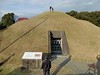
A neighbouring small museum exhibits the replica of the mural painting. Open 9:00-17:00, closed on Mondays and the days around the New Year's Day, admission free.
You may be viewing yesterday's version of this page. To see the most up to date information please register for a free account.
")
Do not use the above information on other web sites or publications without permission of the contributor.
Nearby Images from Flickr


The above images may not be of the site on this page, but were taken nearby. They are loaded from Flickr so please click on them for image credits.
Click here to see more info for this site
Nearby sites
Click here to view sites on an interactive map of the areaKey: Red: member's photo, Blue: 3rd party photo, Yellow: other image, Green: no photo - please go there and take one, Grey: site destroyed
Download sites to:
KML (Google Earth)
GPX (GPS waypoints)
CSV (Garmin/Navman)
CSV (Excel)
To unlock full downloads you need to sign up as a Contributory Member. Otherwise downloads are limited to 50 sites.
Turn off the page maps and other distractions
Nearby sites listing. In the following links * = Image available
256m WNW 292° Sekijin-san Kofun* Sculptured Stone
3.2km ESE 102° Iwatoyama Kofun* Sculptured Stone
3.3km ESE 105° Tsurumiyama Kofun* Sculptured Stone
5.2km E 97° Toyofuku* Sculptured Stone
5.8km SSW 211° Mizuta* Burial Chamber or Dolmen
7.8km N 2° Nankun* Burial Chamber or Dolmen
7.9km S 185° Zoyama* Hillfort
8.0km NNE 27° Kōrasan* Hillfort
9.6km N 1° Ishimaru* Burial Chamber or Dolmen
11.0km W 266° Nobori* Burial Chamber or Dolmen
11.8km NNW 333° Shirakabe Tenmangū shrine* Burial Chamber or Dolmen
12.3km WSW 243° Mishima Jinja shrine (in Fukuoka)* Burial Chamber or Dolmen
12.4km S 189° Iwahata* Burial Chamber or Dolmen
12.8km WSW 258° Isoraishi* Burial Chamber or Dolmen
12.8km WSW 241° Ōgi-no-uchi* Burial Chamber or Dolmen
13.9km SSW 212° Taka-no-o Jinja shrine* Burial Chamber or Dolmen
14.2km WSW 256° Kobo Hachiman Jinja shrine* Burial Chamber or Dolmen
14.5km NNE 33° Tsukajima* Burial Chamber or Dolmen
14.6km NW 324° Funaishi* Burial Chamber or Dolmen
14.6km NNW 332° Himekata* Ring Cairn
15.8km NW 314° Se-no-o* Burial Chamber or Dolmen
16.0km NW 308° Yoshinogari* Ancient Village or Settlement
16.2km NW 310° Hiyoshi Jinja shrine* Burial Chamber or Dolmen
16.3km SSW 193° Ishigamiyama Kofun* Sculptured Stone
16.5km NW 308° Magui* Burial Chamber or Dolmen
View more nearby sites and additional images


 We would like to know more about this location. Please feel free to add a brief description and any relevant information in your own language.
 Wir möchten mehr über diese Stätte erfahren. Bitte zögern Sie nicht, eine kurze Beschreibung und relevante Informationen in Deutsch hinzuzufügen.
 Nous aimerions en savoir encore un peu sur les lieux. S'il vous plaît n'hesitez pas à ajouter une courte description et tous les renseignements pertinents dans votre propre langue.
 Quisieramos informarnos un poco más de las lugares. No dude en añadir una breve descripción y otros datos relevantes en su propio idioma.