
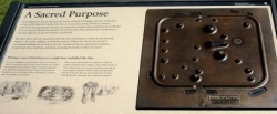

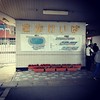
<< Our Photo Pages >> Himekata - Ring Cairn in Japan in Kyūshū
Submitted by Aska on Sunday, 26 December 2010 Page Views: 2837
Iron Age and Later PrehistorySite Name: Himekata Alternative Name: 姫方Country: Japan
NOTE: This site is 8.435 km away from the location you searched for.
Region: Kyūshū Type: Ring Cairn
Nearest Town: Miyaki-chō (Saga pref.) Nearest Village: Minobaru 蓑原
Latitude: 33.352410N Longitude: 130.445240E
Condition:
| 5 | Perfect |
| 4 | Almost Perfect |
| 3 | Reasonable but with some damage |
| 2 | Ruined but still recognisable as an ancient site |
| 1 | Pretty much destroyed, possibly visible as crop marks |
| 0 | No data. |
| -1 | Completely destroyed |
| 5 | Superb |
| 4 | Good |
| 3 | Ordinary |
| 2 | Not Good |
| 1 | Awful |
| 0 | No data. |
| 5 | Can be driven to, probably with disabled access |
| 4 | Short walk on a footpath |
| 3 | Requiring a bit more of a walk |
| 2 | A long walk |
| 1 | In the middle of nowhere, a nightmare to find |
| 0 | No data. |
| 5 | co-ordinates taken by GPS or official recorded co-ordinates |
| 4 | co-ordinates scaled from a detailed map |
| 3 | co-ordinates scaled from a bad map |
| 2 | co-ordinates of the nearest village |
| 1 | co-ordinates of the nearest town |
| 0 | no data |
Internal Links:
External Links:
")
You may be viewing yesterday's version of this page. To see the most up to date information please register for a free account.
Do not use the above information on other web sites or publications without permission of the contributor.
Nearby Images from Flickr
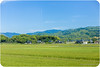

The above images may not be of the site on this page, but were taken nearby. They are loaded from Flickr so please click on them for image credits.
Click here to see more info for this site
Nearby sites
Click here to view sites on an interactive map of the areaKey: Red: member's photo, Blue: 3rd party photo, Yellow: other image, Green: no photo - please go there and take one, Grey: site destroyed
Download sites to:
KML (Google Earth)
GPX (GPS waypoints)
CSV (Garmin/Navman)
CSV (Excel)
To unlock full downloads you need to sign up as a Contributory Member. Otherwise downloads are limited to 50 sites.
Turn off the page maps and other distractions
Nearby sites listing. In the following links * = Image available
2.1km WSW 238° Funaishi* Burial Chamber or Dolmen
2.9km SE 146° Shirakabe Tenmangū shrine* Burial Chamber or Dolmen
4.9km WSW 246° Se-no-o* Burial Chamber or Dolmen
6.1km WSW 245° Hiyoshi Jinja shrine* Burial Chamber or Dolmen
6.4km WSW 242° Yoshinogari* Ancient Village or Settlement
6.8km WSW 245° Magui* Burial Chamber or Dolmen
7.9km ESE 115° Ishimaru* Burial Chamber or Dolmen
8.9km SE 125° Nankun* Burial Chamber or Dolmen
9.4km WSW 242° Fusube Ōishi* Burial Chamber or Dolmen
10.5km WSW 257° Obukumayama* Hillfort
11.8km WSW 252° Muratokunaga* Burial Chamber or Dolmen
11.8km NNE 33° Kiinoki* Hillfort
12.0km ESE 119° Kōrasan* Hillfort
12.1km ENE 65° Ōitai* Burial Chamber or Dolmen
12.7km W 260° Kuboizumi-Maruyama* Burial Chamber or Dolmen
12.9km NE 53° Mitsusawa* Burial Chamber or Dolmen
13.6km SW 223° Kibettō Jinja shrine* Burial Chamber or Dolmen
14.2km SSW 197° Nobori* Burial Chamber or Dolmen
14.4km W 259° Nishikuma Kofun* Passage Grave
14.4km WSW 247° Tofusa* Burial Chamber or Dolmen
14.4km NE 40° Gorōyama Kofun* Passage Grave
14.4km SSE 152° Sekijin-san Kofun* Sculptured Stone
14.6km SSE 152° Kōkadani Kofun* Passage Grave
14.9km E 93° Tsukajima* Burial Chamber or Dolmen
16.6km SSW 200° Isoraishi* Burial Chamber or Dolmen
View more nearby sites and additional images


 We would like to know more about this location. Please feel free to add a brief description and any relevant information in your own language.
 Wir möchten mehr über diese Stätte erfahren. Bitte zögern Sie nicht, eine kurze Beschreibung und relevante Informationen in Deutsch hinzuzufügen.
 Nous aimerions en savoir encore un peu sur les lieux. S'il vous plaît n'hesitez pas à ajouter une courte description et tous les renseignements pertinents dans votre propre langue.
 Quisieramos informarnos un poco más de las lugares. No dude en añadir una breve descripción y otros datos relevantes en su propio idioma.