

<< Our Photo Pages >> Enokida Sekijin - Sculptured Stone in Japan in Kyūshū
Submitted by Aska on Monday, 18 January 2021 Page Views: 253
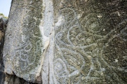
Multi-periodSite Name: Enokida Sekijin Alternative Name: 榎田石人Country: Japan
NOTE: This site is 0.715 km away from the location you searched for.
Region: Kyūshū Type: Sculptured Stone
Nearest Town: Minami-Shimabara (Nagasaki prefecture) Nearest Village: AriechōKogawa 有家町小川
Latitude: 32.657690N Longitude: 130.305020E
Condition:
| 5 | Perfect |
| 4 | Almost Perfect |
| 3 | Reasonable but with some damage |
| 2 | Ruined but still recognisable as an ancient site |
| 1 | Pretty much destroyed, possibly visible as crop marks |
| 0 | No data. |
| -1 | Completely destroyed |
| 5 | Superb |
| 4 | Good |
| 3 | Ordinary |
| 2 | Not Good |
| 1 | Awful |
| 0 | No data. |
| 5 | Can be driven to, probably with disabled access |
| 4 | Short walk on a footpath |
| 3 | Requiring a bit more of a walk |
| 2 | A long walk |
| 1 | In the middle of nowhere, a nightmare to find |
| 0 | No data. |
| 5 | co-ordinates taken by GPS or official recorded co-ordinates |
| 4 | co-ordinates scaled from a detailed map |
| 3 | co-ordinates scaled from a bad map |
| 2 | co-ordinates of the nearest village |
| 1 | co-ordinates of the nearest town |
| 0 | no data |
Internal Links:
External Links:
")
In Kokawa-Enokida commune, there are 2 small shrines sheltering several stone deities. 2 books on the cultural heritages in Arie-town contain the photos of a saruishi in Enokida commune in typical shape with massive body and a small head. But such statue in definitive shape cannot be found in both shrine. Maybe one of a pair stones in the smaller shrine with small white body and glued head of another black stone is the broken fragment of the statue.
You may be viewing yesterday's version of this page. To see the most up to date information please register for a free account.
")
")
")
Do not use the above information on other web sites or publications without permission of the contributor.
Nearby Images from Flickr


The above images may not be of the site on this page, but were taken nearby. They are loaded from Flickr so please click on them for image credits.
Click here to see more info for this site
Nearby sites
Click here to view sites on an interactive map of the areaKey: Red: member's photo, Blue: 3rd party photo, Yellow: other image, Green: no photo - please go there and take one, Grey: site destroyed
Download sites to:
KML (Google Earth)
GPX (GPS waypoints)
CSV (Garmin/Navman)
CSV (Excel)
To unlock full downloads you need to sign up as a Contributory Member. Otherwise downloads are limited to 50 sites.
Turn off the page maps and other distractions
Nearby sites listing. In the following links * = Image available
599m NE 45° Kumano Sekijin* Sculptured Stone
1.1km E 84° Nishi-Onzuka* Burial Chamber or Dolmen
1.5km N 6° Yadonashi Jizō* Sculptured Stone
1.6km N 2° Nagata Sekijin* Sculptured Stone
2.4km N 351° Myōkō Kofun Sekijin* Sculptured Stone
2.4km NNW 349° Kirishitan Shiseki Kōen* Sculptured Stone
3.9km N 352° Miminashi Jizō* Sculptured Stone
4.0km NNE 33° Kiba Resseki-Suimon* Hillfort
5.7km N 351° Saruishi (in ex-Arie town)* Sculptured Stone
9.5km WNW 285° Harayama* Burial Chamber or Dolmen
16.2km N 1° Kureishibaru* Stone Circle
19.2km NNE 13° Keikaen* Burial Chamber or Dolmen
22.0km SSW 205° Tsuma-no-hana* Chambered Cairn
22.3km NNW 328° Saruishi (in ex-Azuma town)* Sculptured Stone
27.6km S 172° Miyazaki cists* Cist
31.4km WNW 289° Magarizaki Kofun* Chambered Cairn
32.1km NNW 341° Izaki Burial Chamber or Dolmen
34.3km NE 36° Benzaiten Kofun* Passage Grave
35.7km NE 35° Toshi-no-Kami* Burial Chamber or Dolmen
36.6km NW 312° Fūkandake* Burial Chamber or Dolmen
37.3km NE 41° Jōgasaki* Burial Chamber or Dolmen
37.7km NE 43° Ikura-kita Hachiman shrine* Burial Chamber or Dolmen
38.8km NE 37° Sugawara Jinja shrine (in Tamana)* Burial Chamber or Dolmen
39.4km ENE 67° Kitaoka Park* Modern Stone Circle etc
39.6km NNE 18° Manda Itsukushima Jinja shrine* Burial Chamber or Dolmen
View more nearby sites and additional images


 We would like to know more about this location. Please feel free to add a brief description and any relevant information in your own language.
 Wir möchten mehr über diese Stätte erfahren. Bitte zögern Sie nicht, eine kurze Beschreibung und relevante Informationen in Deutsch hinzuzufügen.
 Nous aimerions en savoir encore un peu sur les lieux. S'il vous plaît n'hesitez pas à ajouter une courte description et tous les renseignements pertinents dans votre propre langue.
 Quisieramos informarnos un poco más de las lugares. No dude en añadir una breve descripción y otros datos relevantes en su propio idioma.