


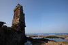
<< Our Photo Pages >> Gushikawa Gusuku (on Kume-jima island) - Hillfort in Japan in Kyūshū
Submitted by Aska on Sunday, 10 April 2016 Page Views: 1254
Medieval (High and Late)Site Name: Gushikawa Gusuku (on Kume-jima island) Alternative Name: 具志川城Country: Japan
NOTE: This site is 170.321 km away from the location you searched for.
Region: Kyūshū Type: Hillfort
Nearest Town: Kumejima island (Okinawa pref.) Nearest Village: Nakandakari 仲村渠
Latitude: 26.383020N Longitude: 126.750950E
Condition:
| 5 | Perfect |
| 4 | Almost Perfect |
| 3 | Reasonable but with some damage |
| 2 | Ruined but still recognisable as an ancient site |
| 1 | Pretty much destroyed, possibly visible as crop marks |
| 0 | No data. |
| -1 | Completely destroyed |
| 5 | Superb |
| 4 | Good |
| 3 | Ordinary |
| 2 | Not Good |
| 1 | Awful |
| 0 | No data. |
| 5 | Can be driven to, probably with disabled access |
| 4 | Short walk on a footpath |
| 3 | Requiring a bit more of a walk |
| 2 | A long walk |
| 1 | In the middle of nowhere, a nightmare to find |
| 0 | No data. |
| 5 | co-ordinates taken by GPS or official recorded co-ordinates |
| 4 | co-ordinates scaled from a detailed map |
| 3 | co-ordinates scaled from a bad map |
| 2 | co-ordinates of the nearest village |
| 1 | co-ordinates of the nearest town |
| 0 | no data |
Internal Links:
External Links:
")
The most fine Gusuku hillfort ruin on the Kume-jima island on the shore.
You may be viewing yesterday's version of this page. To see the most up to date information please register for a free account.
Do not use the above information on other web sites or publications without permission of the contributor.
Nearby Images from Flickr
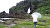
The above images may not be of the site on this page, but were taken nearby. They are loaded from Flickr so please click on them for image credits.
Click here to see more info for this site
Nearby sites
Click here to view sites on an interactive map of the areaKey: Red: member's photo, Blue: 3rd party photo, Yellow: other image, Green: no photo - please go there and take one, Grey: site destroyed
Download sites to:
KML (Google Earth)
GPX (GPS waypoints)
CSV (Garmin/Navman)
CSV (Excel)
To unlock full downloads you need to sign up as a Contributory Member. Otherwise downloads are limited to 50 sites.
Turn off the page maps and other distractions
Nearby sites listing. In the following links * = Image available
1.8km SW 228° Shimojibaru cave* Cave or Rock Shelter
2.0km ESE 109° Ue Gusuku* Hillfort
3.0km E 95° Utida-Ishi* Carving
3.1km S 185° Taizan Ishigantō (in Kume-jima island)* Standing Stone (Menhir)
3.8km S 178° Kominato Matsubara-baka* Chambered Tomb
4.3km SSE 155° Ishidōnī* Holy Well or Sacred Spring
4.7km SSE 165° Chinaha Gushiku* Hillfort
7.1km ESE 121° Kikumura Family Residence garden* Modern Stone Circle etc
8.0km ESE 119° Sonami* Artificial Mound
9.1km SE 125° TatamiIshi* Natural Stone / Erratic / Other Natural Feature
9.8km SSE 146° Shimajiri-no-Ishibaka* Chambered Cairn
51.2km ENE 65° Ban’ya-Tōmidai (in Aguni-jima island)* Artificial Mound
52.3km ENE 65° Tūji or Chūdi* Holy Well or Sacred Spring
93.0km ESE 104° Gushi Hitati* Natural Stone / Erratic / Other Natural Feature
94.2km ESE 102° Yamashita-chō cave* Cave or Rock Shelter
95.0km E 101° Tomb of Tokashiki Sanrā* Chambered Tomb
95.8km E 100° Mekaru necropolis* Chambered Tomb
97.1km ESE 110° Gushikawa-jō (in Itoman city)* Hillfort
97.4km E 100° Tomb of Ginowan branch royal family* Chambered Tomb
97.6km E 99° Tomb of Urasoe branch royal family* Chambered Tomb
97.8km E 101° Tama Udun* Chambered Tomb
97.9km E 101° Tomb of Takushi Uēkata* Chambered Tomb
98.1km E 98° Iso-no-Takauhaka* Rock Cut Tomb
98.3km E 101° Shuri-jō* Hillfort
98.4km ESE 110° Kasakanjā* Natural Stone / Erratic / Other Natural Feature
View more nearby sites and additional images


 We would like to know more about this location. Please feel free to add a brief description and any relevant information in your own language.
 Wir möchten mehr über diese Stätte erfahren. Bitte zögern Sie nicht, eine kurze Beschreibung und relevante Informationen in Deutsch hinzuzufügen.
 Nous aimerions en savoir encore un peu sur les lieux. S'il vous plaît n'hesitez pas à ajouter une courte description et tous les renseignements pertinents dans votre propre langue.
 Quisieramos informarnos un poco más de las lugares. No dude en añadir una breve descripción y otros datos relevantes en su propio idioma.