


<< Our Photo Pages >> Gunung Kawi - Ancient Temple in Indonesia
Submitted by ModernExplorers on Monday, 14 May 2012 Page Views: 5346
Multi-periodSite Name: Gunung KawiCountry: Indonesia
NOTE: This site is 20.065 km away from the location you searched for.
Type: Ancient Temple
Nearest Town: Ubud
Latitude: 8.4234S Longitude: 115.312300E
Condition:
| 5 | Perfect |
| 4 | Almost Perfect |
| 3 | Reasonable but with some damage |
| 2 | Ruined but still recognisable as an ancient site |
| 1 | Pretty much destroyed, possibly visible as crop marks |
| 0 | No data. |
| -1 | Completely destroyed |
| 5 | Superb |
| 4 | Good |
| 3 | Ordinary |
| 2 | Not Good |
| 1 | Awful |
| 0 | No data. |
| 5 | Can be driven to, probably with disabled access |
| 4 | Short walk on a footpath |
| 3 | Requiring a bit more of a walk |
| 2 | A long walk |
| 1 | In the middle of nowhere, a nightmare to find |
| 0 | No data. |
| 5 | co-ordinates taken by GPS or official recorded co-ordinates |
| 4 | co-ordinates scaled from a detailed map |
| 3 | co-ordinates scaled from a bad map |
| 2 | co-ordinates of the nearest village |
| 1 | co-ordinates of the nearest town |
| 0 | no data |
Internal Links:
External Links:
I have visited· I would like to visit
ModernExplorers visited on 8th Oct 2008 - their rating: Cond: 3 Amb: 4 Access: 3 Beautiful rock cut shrines and temples
")
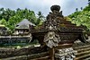
The complex comprises 10 rock-cut candi (shrines) carved into the cliff face. They stand in 7m-high (23 ft-high) sheltered niches cut into the sheer cliff face. These monuments are thought to be dedicated to King Anak Wungsu of the Udayana dynasty and his favourite queens.
You may be viewing yesterday's version of this page. To see the most up to date information please register for a free account.
")
")
")
Do not use the above information on other web sites or publications without permission of the contributor.
Nearby Images from Flickr

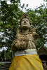
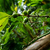
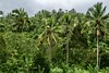

The above images may not be of the site on this page, but were taken nearby. They are loaded from Flickr so please click on them for image credits.
Click here to see more info for this site
Nearby sites
Click here to view sites on an interactive map of the areaKey: Red: member's photo, Blue: 3rd party photo, Yellow: other image, Green: no photo - please go there and take one, Grey: site destroyed
Download sites to:
KML (Google Earth)
GPX (GPS waypoints)
CSV (Garmin/Navman)
CSV (Excel)
To unlock full downloads you need to sign up as a Contributory Member. Otherwise downloads are limited to 50 sites.
Turn off the page maps and other distractions
Nearby sites listing. In the following links * = Image available
10.5km S 185° Goa Garba* Cave or Rock Shelter
10.9km S 191° Archaelogical Museum Gedong Arca* Museum
12.2km S 190° Yeh Pulu* Carving
16.3km ENE 70° Pura Besakih Ancient Temple
49.7km SSW 198° Pura Batu Pageh* Ancient Temple
99.5km WNW 286° Museum Manusia Purba Gilimanuk* Museum
469.4km ESE 107° Waikabubak Burial Chamber or Dolmen
472.1km ESE 107° Waikabubak East Burial Chamber or Dolmen
485.7km ESE 106° Anakalang Burial Chamber or Dolmen
536.0km W 278° Prambanan Ancient Temple
543.3km W 279° The Lost World Stonehenge. Cangkringan, Sleman. Modern Stone Circle etc
564.4km E 92° Liang Bua Cave Cave or Rock Shelter
569.8km W 279° Borobudur temple* Ancient Temple
569.8km W 279° Dieng Plateau Temple* Ancient Temple
582.8km NE 52° Maros (Sulawesi) Rock Art
588.7km ESE 104° Rindi Umalulu Burial Chamber or Dolmen
610.1km WNW 282° Candi Bima Ancient Temple
610.7km WNW 282° Candi Arjuna Ancient Temple
610.7km WNW 282° Candi Gatotkaca Ancient Temple
615.7km NE 52° Leang Leang Rock Art
625.7km E 95° Bena Village Megaliths* Ancient Village or Settlement
770.6km WNW 282° Cipari Ancient Village or Settlement
775.5km NE 39° Pali Standing Stones* Standing Stones
785.9km NE 40° Londa Tana Toraja Rock Cut Tomb
789.2km NE 40° Ke´te Kesu´ Standing Stones* Stone Circle
View more nearby sites and additional images


 We would like to know more about this location. Please feel free to add a brief description and any relevant information in your own language.
 Wir möchten mehr über diese Stätte erfahren. Bitte zögern Sie nicht, eine kurze Beschreibung und relevante Informationen in Deutsch hinzuzufügen.
 Nous aimerions en savoir encore un peu sur les lieux. S'il vous plaît n'hesitez pas à ajouter une courte description et tous les renseignements pertinents dans votre propre langue.
 Quisieramos informarnos un poco más de las lugares. No dude en añadir una breve descripción y otros datos relevantes en su propio idioma.