


<< Text Pages >> Candi Arjuna - Ancient Temple in Indonesia
Submitted by KaiHofmann on Monday, 03 July 2017 Page Views: 1410
Multi-periodSite Name: Candi ArjunaCountry: Indonesia
NOTE: This site is 295.166 km away from the location you searched for.
Type: Ancient Temple
Nearest Town: Dieng Kulong
Latitude: 7.205206S Longitude: 109.906952E
Condition:
| 5 | Perfect |
| 4 | Almost Perfect |
| 3 | Reasonable but with some damage |
| 2 | Ruined but still recognisable as an ancient site |
| 1 | Pretty much destroyed, possibly visible as crop marks |
| 0 | No data. |
| -1 | Completely destroyed |
| 5 | Superb |
| 4 | Good |
| 3 | Ordinary |
| 2 | Not Good |
| 1 | Awful |
| 0 | No data. |
| 5 | Can be driven to, probably with disabled access |
| 4 | Short walk on a footpath |
| 3 | Requiring a bit more of a walk |
| 2 | A long walk |
| 1 | In the middle of nowhere, a nightmare to find |
| 0 | No data. |
| 5 | co-ordinates taken by GPS or official recorded co-ordinates |
| 4 | co-ordinates scaled from a detailed map |
| 3 | co-ordinates scaled from a bad map |
| 2 | co-ordinates of the nearest village |
| 1 | co-ordinates of the nearest town |
| 0 | no data |
Internal Links:
External Links:
Ancient Temple in Indonesia
Ancient Hindu temple of the 8th to the 9th century CE on the Dieng plateau in central Java.
You may be viewing yesterday's version of this page. To see the most up to date information please register for a free account.
Do not use the above information on other web sites or publications without permission of the contributor.
Nearby Images from Flickr
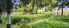
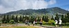
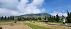
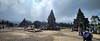
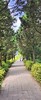
The above images may not be of the site on this page, but were taken nearby. They are loaded from Flickr so please click on them for image credits.
Click here to see more info for this site
Nearby sites
Click here to view sites on an interactive map of the areaKey: Red: member's photo, Blue: 3rd party photo, Yellow: other image, Green: no photo - please go there and take one, Grey: site destroyed
Download sites to:
KML (Google Earth)
GPX (GPS waypoints)
CSV (Garmin/Navman)
CSV (Excel)
To unlock full downloads you need to sign up as a Contributory Member. Otherwise downloads are limited to 50 sites.
Turn off the page maps and other distractions
Nearby sites listing. In the following links * = Image available
412m SSW 194° Candi Gatotkaca Ancient Temple
1.1km SSE 159° Candi Bima Ancient Temple
55.1km SE 144° Dieng Plateau Temple* Ancient Temple
55.5km SE 144° Borobudur temple* Ancient Temple
74.2km SE 126° The Lost World Stonehenge. Cangkringan, Sleman. Modern Stone Circle etc
88.6km SE 133° Prambanan Ancient Temple
160.2km W 279° Cipari Ancient Village or Settlement
205.8km W 271° Mount Sadahurip* Natural Stone / Erratic / Other Natural Feature
219.6km W 273° Candi Gangkuang Ancient Temple
263.8km W 276° Footprint Stone, Mount Paseban Natural Stone / Erratic / Other Natural Feature
264.8km W 276° Mount Lalakon Not Known (by us)
315.3km W 274° Gunung Padang* Ancient Temple
359.3km WNW 288° Museum Nasional* Museum
375.5km W 275° Situs Pangguyangan Artificial Mound
376.4km W 275° Situs Tugu Cengku* Standing Stone (Menhir)
422.6km WNW 282° Cibedug Stone Stone Row / Alignment
511.4km ESE 102° Museum Manusia Purba Gilimanuk* Museum
607.6km ESE 108° Pura Batu Pageh* Ancient Temple
610.7km ESE 103° Gunung Kawi* Ancient Temple
611.0km ESE 104° Archaelogical Museum Gedong Arca* Museum
611.3km ESE 104° Yeh Pulu* Carving
612.1km ESE 104° Goa Garba* Cave or Rock Shelter
624.5km ESE 102° Pura Besakih Ancient Temple
789.4km WNW 302° Bilik Kubur Batu Burial Chamber or Dolmen
801.2km WNW 295° Tegurwangi Sculptured Stone
View more nearby sites and additional images


 We would like to know more about this location. Please feel free to add a brief description and any relevant information in your own language.
 Wir möchten mehr über diese Stätte erfahren. Bitte zögern Sie nicht, eine kurze Beschreibung und relevante Informationen in Deutsch hinzuzufügen.
 Nous aimerions en savoir encore un peu sur les lieux. S'il vous plaît n'hesitez pas à ajouter une courte description et tous les renseignements pertinents dans votre propre langue.
 Quisieramos informarnos un poco más de las lugares. No dude en añadir una breve descripción y otros datos relevantes en su propio idioma.