

<< Our Photo Pages >> Stone Age 2001 - Modern Stone Circle etc in Italy in Trentino-Alto Adige
Submitted by ladrin on Monday, 16 January 2017 Page Views: 1799
Modern SitesSite Name: Stone Age 2001 Alternative Name: Steinzeit 2001Country: Italy Region: Trentino-Alto Adige Type: Modern Stone Circle etc
Nearest Town: Merano Nearest Village: Algund
Latitude: 46.677537N Longitude: 11.125990E
Condition:
| 5 | Perfect |
| 4 | Almost Perfect |
| 3 | Reasonable but with some damage |
| 2 | Ruined but still recognisable as an ancient site |
| 1 | Pretty much destroyed, possibly visible as crop marks |
| 0 | No data. |
| -1 | Completely destroyed |
| 5 | Superb |
| 4 | Good |
| 3 | Ordinary |
| 2 | Not Good |
| 1 | Awful |
| 0 | No data. |
| 5 | Can be driven to, probably with disabled access |
| 4 | Short walk on a footpath |
| 3 | Requiring a bit more of a walk |
| 2 | A long walk |
| 1 | In the middle of nowhere, a nightmare to find |
| 0 | No data. |
| 5 | co-ordinates taken by GPS or official recorded co-ordinates |
| 4 | co-ordinates scaled from a detailed map |
| 3 | co-ordinates scaled from a bad map |
| 2 | co-ordinates of the nearest village |
| 1 | co-ordinates of the nearest town |
| 0 | no data |
Internal Links:
External Links:
I have visited· I would like to visit
u2u2u2u2 would like to visit
")
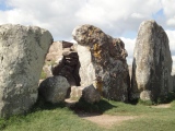
A beautiful example of "Land Art" built by the community of South Tyrolean Algund in collaboration with the German artist Heinrich Bunzel and geometer Martin Geier.
On the area of 7500 sq metres 101 stones of different sizes have been erected with a little artificial pond in the middle. Some of the stones are more than 2m in height and weigh 2.5t. This stone represents the theme of the sun with ten rays.
You may be viewing yesterday's version of this page. To see the most up to date information please register for a free account.
")
")
")
")
Do not use the above information on other web sites or publications without permission of the contributor.
Nearby Images from Flickr
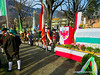

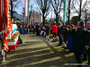
The above images may not be of the site on this page, but were taken nearby. They are loaded from Flickr so please click on them for image credits.
Click here to see more info for this site
Nearby sites
Click here to view sites on an interactive map of the areaKey: Red: member's photo, Blue: 3rd party photo, Yellow: other image, Green: no photo - please go there and take one, Grey: site destroyed
Download sites to:
KML (Google Earth)
GPX (GPS waypoints)
CSV (Garmin/Navman)
CSV (Excel)
To unlock full downloads you need to sign up as a Contributory Member. Otherwise downloads are limited to 50 sites.
Turn off the page maps and other distractions
Nearby sites listing. In the following links * = Image available
5.8km NNW 343° Spronser Seen (Sprons Lakes)* Rock Art
19.7km WSW 253° Untere Grübelplatte (Schalenstein)* Rock Art
21.2km WNW 284° ArcheoPark and Museum Val Senales* Museum
23.8km NW 316° Kaser Menhir Standing Stone (Menhir)
24.6km WNW 297° Ötzi Memorial* Marker Stone
25.2km NW 320° Hohler Stein Kaser Natural Stone / Erratic / Other Natural Feature
25.4km NW 324° Mutsbichl Schalensteine Rock Art
26.1km SE 139° South Tyrol Museum of Archaeology* Museum
27.6km NNW 346° Lenzenalm Schalenstein Rock Art
28.2km NNW 336° Heiligkreuz Teufelsfelsen Rock Art
29.0km SE 127° Der Menhir von Wolfsgruben* Standing Stone (Menhir)
29.6km N 0° Windachtal Schalenstein II Rock Art
32.7km NNW 349° Windachtal Schalenstein I Rock Art
33.2km NNW 345° Schlangenfelsen (Snake's rock) Rock Art
33.6km NNW 345° Sölden menhir* Standing Stone (Menhir)
38.5km ESE 117° Schlern Natural Stone / Erratic / Other Natural Feature
41.6km E 82° Bildstein (Elvas)* Rock Art
44.0km NNW 345° Burgstein Schalenstein Rock Art
46.8km NNW 341° Innerbergalm Schalenstein Rock Art
50.2km NNE 13° Cupstone Lithagrub-Profegl Alm* Rock Art
51.2km NNE 15° Cupstone Menhir Viggar Valley Tyrol* Rock Art
52.5km NNW 344° Ötzi Village* Museum
56.6km NW 322° Schalenstein Prutz Rock Art
60.9km NNW 341° Sautens Opferstein Natural Stone / Erratic / Other Natural Feature
61.6km NNE 23° Cupstone Slabs-Graveyard Tarzens* Rock Art
View more nearby sites and additional images


 We would like to know more about this location. Please feel free to add a brief description and any relevant information in your own language.
 Wir möchten mehr über diese Stätte erfahren. Bitte zögern Sie nicht, eine kurze Beschreibung und relevante Informationen in Deutsch hinzuzufügen.
 Nous aimerions en savoir encore un peu sur les lieux. S'il vous plaît n'hesitez pas à ajouter une courte description et tous les renseignements pertinents dans votre propre langue.
 Quisieramos informarnos un poco más de las lugares. No dude en añadir una breve descripción y otros datos relevantes en su propio idioma.