


<< Text Pages >> Tapak Megalitik - Stone Row / Alignment in Malaysia
Submitted by KaiHofmann on Wednesday, 20 December 2023 Page Views: 134
Neolithic and Bronze AgeSite Name: Tapak MegalitikCountry: Malaysia
NOTE: This site is 21.071 km away from the location you searched for.
Type: Stone Row / Alignment
Nearest Town: Seremban Nearest Village: Kampung Baharu Ulu Bendol
Latitude: 2.740110N Longitude: 102.127600E
Condition:
| 5 | Perfect |
| 4 | Almost Perfect |
| 3 | Reasonable but with some damage |
| 2 | Ruined but still recognisable as an ancient site |
| 1 | Pretty much destroyed, possibly visible as crop marks |
| 0 | No data. |
| -1 | Completely destroyed |
| 5 | Superb |
| 4 | Good |
| 3 | Ordinary |
| 2 | Not Good |
| 1 | Awful |
| 0 | No data. |
| 5 | Can be driven to, probably with disabled access |
| 4 | Short walk on a footpath |
| 3 | Requiring a bit more of a walk |
| 2 | A long walk |
| 1 | In the middle of nowhere, a nightmare to find |
| 0 | No data. |
| 5 | co-ordinates taken by GPS or official recorded co-ordinates |
| 4 | co-ordinates scaled from a detailed map |
| 3 | co-ordinates scaled from a bad map |
| 2 | co-ordinates of the nearest village |
| 1 | co-ordinates of the nearest town |
| 0 | no data |
Internal Links:
External Links:
Stone Row / Alignment in Malaysia
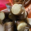
Stone arrangement of around 9 smaller standing stones (the largest stone is around 1.60m tall) besides a road.
You may be viewing yesterday's version of this page. To see the most up to date information please register for a free account.
Do not use the above information on other web sites or publications without permission of the contributor.
Nearby Images from Flickr
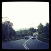
The above images may not be of the site on this page, but were taken nearby. They are loaded from Flickr so please click on them for image credits.
Click here to see more info for this site
Nearby sites
Click here to view sites on an interactive map of the areaKey: Red: member's photo, Blue: 3rd party photo, Yellow: other image, Green: no photo - please go there and take one, Grey: site destroyed
Download sites to:
KML (Google Earth)
GPX (GPS waypoints)
CSV (Garmin/Navman)
CSV (Excel)
To unlock full downloads you need to sign up as a Contributory Member. Otherwise downloads are limited to 50 sites.
Turn off the page maps and other distractions
Nearby sites listing. In the following links * = Image available
30.5km S 170° Melaka* Standing Stones
34.5km SSW 201° Kompleks Sejarah Pengkalan Kempas* Standing Stones
36.3km SSE 154° Masjid Kampung Kemuning Standing Stones
43.9km SSE 165° Makam Datuk Paduka Seri Maharaja Lela Standing Stones
52.8km WNW 295° Laman Megalit* Standing Stones
65.9km NW 312° Muzium Negara* Museum
234.9km NNW 332° Gua Tambun Rock Art
256.3km N 351° Gua Cha Cave or Rock Shelter
258.5km NNE 13° Bewah Cave Cave or Rock Shelter
287.4km NNW 334° Lenggong Archaeological Museum* Museum
343.4km NNW 328° Cherok Tokun Carving
383.6km NNW 330° Lembah Bujang Ancient Village or Settlement
534.4km S 181° Ngalau Ulu Tjangko Cave* Cave or Rock Shelter
673.2km NNW 339° Nakhon Si Thammarat National Museum* Museum
674.4km NNW 339° Wat Phra Mahathat* Ancient Temple
677.2km NNW 339° Nakhon Si Thammarat City Wall* Ancient Village or Settlement
703.6km NNW 329° Tham Lang Rongrien Cave or Rock Shelter
715.1km SSE 164° Bilik Kubur Batu Burial Chamber or Dolmen
716.1km NW 325° Thalang Museum Museum
727.0km NNW 340° Khao Ka Shiva Temples* Ancient Temple
733.3km NNW 329° Tham Phee Hua Toh Rock Art
739.4km NNW 327° Naga Cave* Rock Art
741.4km NNW 327° Khao Khian* Rock Art
755.9km S 169° Segayun megalithic site Ancient Village or Settlement
761.9km S 170° Skendal Standing Stones
View more nearby sites and additional images


 We would like to know more about this location. Please feel free to add a brief description and any relevant information in your own language.
 Wir möchten mehr über diese Stätte erfahren. Bitte zögern Sie nicht, eine kurze Beschreibung und relevante Informationen in Deutsch hinzuzufügen.
 Nous aimerions en savoir encore un peu sur les lieux. S'il vous plaît n'hesitez pas à ajouter une courte description et tous les renseignements pertinents dans votre propre langue.
 Quisieramos informarnos un poco más de las lugares. No dude en añadir una breve descripción y otros datos relevantes en su propio idioma.