


<< Our Photo Pages >> Rillenstein Kortenbeck - Standing Stone (Menhir) in Germany in Saxony-Anhalt
Submitted by KaiHofmann on Saturday, 23 November 2013 Page Views: 1509
Neolithic and Bronze AgeSite Name: Rillenstein KortenbeckCountry: Germany Land: Saxony-Anhalt Type: Standing Stone (Menhir)
Nearest Town: Salzwedel Nearest Village: Kortenbeck
Latitude: 52.837050N Longitude: 10.895130E
Condition:
| 5 | Perfect |
| 4 | Almost Perfect |
| 3 | Reasonable but with some damage |
| 2 | Ruined but still recognisable as an ancient site |
| 1 | Pretty much destroyed, possibly visible as crop marks |
| 0 | No data. |
| -1 | Completely destroyed |
| 5 | Superb |
| 4 | Good |
| 3 | Ordinary |
| 2 | Not Good |
| 1 | Awful |
| 0 | No data. |
| 5 | Can be driven to, probably with disabled access |
| 4 | Short walk on a footpath |
| 3 | Requiring a bit more of a walk |
| 2 | A long walk |
| 1 | In the middle of nowhere, a nightmare to find |
| 0 | No data. |
| 5 | co-ordinates taken by GPS or official recorded co-ordinates |
| 4 | co-ordinates scaled from a detailed map |
| 3 | co-ordinates scaled from a bad map |
| 2 | co-ordinates of the nearest village |
| 1 | co-ordinates of the nearest town |
| 0 | no data |
Internal Links:
External Links:
I have visited· I would like to visit
johnstone visited on 25th Aug 2020 - their rating: Cond: 4 Amb: 3 Access: 5
")
A 1.5m high standing stone with a furrow 0.4m below the top of the stone.
You may be viewing yesterday's version of this page. To see the most up to date information please register for a free account.
")
")
")
Do not use the above information on other web sites or publications without permission of the contributor.
Nearby Images from Flickr
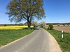
The above images may not be of the site on this page, but were taken nearby. They are loaded from Flickr so please click on them for image credits.
Click here to see more info for this site
Nearby sites
Click here to view sites on an interactive map of the areaKey: Red: member's photo, Blue: 3rd party photo, Yellow: other image, Green: no photo - please go there and take one, Grey: site destroyed
Download sites to:
KML (Google Earth)
GPX (GPS waypoints)
CSV (Garmin/Navman)
CSV (Excel)
To unlock full downloads you need to sign up as a Contributory Member. Otherwise downloads are limited to 50 sites.
Turn off the page maps and other distractions
Nearby sites listing. In the following links * = Image available
5.8km WSW 240° Lenekenstein* Standing Stone (Menhir)
9.6km SSW 200° Schadewohl Steingrab 2* Chambered Tomb
9.6km SSW 202° Schadewohl Steingrab 1* Chambered Tomb
9.7km SSW 198° Schadewohl Steingrab 3* Chambered Tomb
10.3km SSW 193° Diesdorf Steingrab 1* Chambered Tomb
11.0km S 190° Diesdorf Steingrab 2* Chambered Tomb
11.3km S 189° Diesdorf Steingrab 3* Chambered Tomb
11.7km S 188° Molmke Steingrab* Chambered Tomb
11.8km SE 129° Leetze Steingrab 1* Chambered Tomb
11.8km SE 129° Leetze Steingrab 2* Chambered Tomb
11.9km SE 129° Leetze Steingrab 3* Long Barrow
12.0km SE 130° Leetze Steingrab 4* Chambered Tomb
12.1km SE 130° Leetze Steingrab 5* Long Barrow
12.3km SE 131° Leetze Steingrab 6* Long Barrow
12.5km SE 132° Leetze Steingrab 7* Passage Grave
12.5km SE 132° Leetze Steingrab 8* Passage Grave
12.6km SSE 158° Mehmke Steingrab 3* Chambered Tomb
12.7km SSE 159° Mehmke Steingrab 2* Chambered Tomb
12.9km S 180° Drebenstedt Langbett* Long Barrow
13.3km S 172° Bornsen Steingrab 2* Chambered Tomb
13.5km N 5° Reddereitz Findlingspark* Natural Stone / Erratic / Other Natural Feature
13.7km N 4° Reddereitz Steingrab 2* Long Barrow
13.8km N 3° Reddereitz Steingrab 1* Chambered Tomb
14.1km SE 144° Bierstedt Steingrab* Chambered Tomb
14.2km N 3° Reddereitz Steingrab 3 Long Barrow
View more nearby sites and additional images


 We would like to know more about this location. Please feel free to add a brief description and any relevant information in your own language.
 Wir möchten mehr über diese Stätte erfahren. Bitte zögern Sie nicht, eine kurze Beschreibung und relevante Informationen in Deutsch hinzuzufügen.
 Nous aimerions en savoir encore un peu sur les lieux. S'il vous plaît n'hesitez pas à ajouter une courte description et tous les renseignements pertinents dans votre propre langue.
 Quisieramos informarnos un poco más de las lugares. No dude en añadir una breve descripción y otros datos relevantes en su propio idioma.