

<< Text Pages >> Druidenstein Stinzendorf - Natural Stone / Erratic / Other Natural Feature in Germany in Bavaria
Submitted by KaiHofmann on Saturday, 23 January 2016 Page Views: 1036
Natural PlacesSite Name: Druidenstein StinzendorfCountry: Germany
NOTE: This site is 8.238 km away from the location you searched for.
Land: Bavaria Type: Natural Stone / Erratic / Other Natural Feature
Nearest Town: Nuremberg Nearest Village: Stinzendorf
Latitude: 49.455383N Longitude: 10.796301E
Condition:
| 5 | Perfect |
| 4 | Almost Perfect |
| 3 | Reasonable but with some damage |
| 2 | Ruined but still recognisable as an ancient site |
| 1 | Pretty much destroyed, possibly visible as crop marks |
| 0 | No data. |
| -1 | Completely destroyed |
| 5 | Superb |
| 4 | Good |
| 3 | Ordinary |
| 2 | Not Good |
| 1 | Awful |
| 0 | No data. |
| 5 | Can be driven to, probably with disabled access |
| 4 | Short walk on a footpath |
| 3 | Requiring a bit more of a walk |
| 2 | A long walk |
| 1 | In the middle of nowhere, a nightmare to find |
| 0 | No data. |
| 5 | co-ordinates taken by GPS or official recorded co-ordinates |
| 4 | co-ordinates scaled from a detailed map |
| 3 | co-ordinates scaled from a bad map |
| 2 | co-ordinates of the nearest village |
| 1 | co-ordinates of the nearest town |
| 0 | no data |
Internal Links:
External Links:
Natural Stone / Erratic / Other Natural Feature in Bavaria
Large boulder probably with cups (not sure if natural or human-made) and many local myths were told about him. It was destroyed as a part of a modern quarry in the 19th century. Today a memorial stone is standing at the former place where the boulder was.
You may be viewing yesterday's version of this page. To see the most up to date information please register for a free account.
Do not use the above information on other web sites or publications without permission of the contributor.
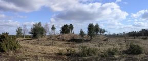
Nearby Images from Flickr


The above images may not be of the site on this page, but were taken nearby. They are loaded from Flickr so please click on them for image credits.
Click here to see more info for this site
Nearby sites
Click here to view sites on an interactive map of the areaKey: Red: member's photo, Blue: 3rd party photo, Yellow: other image, Green: no photo - please go there and take one, Grey: site destroyed
Download sites to:
KML (Google Earth)
GPX (GPS waypoints)
CSV (Garmin/Navman)
CSV (Excel)
To unlock full downloads you need to sign up as a Contributory Member. Otherwise downloads are limited to 50 sites.
Turn off the page maps and other distractions
Nearby sites listing. In the following links * = Image available
7.9km ESE 123° Hügelgräber Erlach Round Barrow(s)
19.9km NNE 30° Kosbacher Altar* Round Barrow(s)
20.4km SW 236° Kleiner Markmann Standing Stone (Menhir)
20.8km E 91° Naturhistorisches Museum Nürnberg* Museum
20.9km WSW 237° Grosser Markmann Standing Stone (Menhir)
25.4km ENE 71° Kraftshofer Forst* Round Barrow(s)
26.7km NNW 326° Oasen der Sinne* Museum
29.1km NE 38° Mark-forst Grabhügel Artificial Mound
29.1km E 83° Behringersdorf* Chambered Tomb
30.1km SSE 152° Druidenstein Mäbenberg Natural Stone / Erratic / Other Natural Feature
30.1km W 267° Summstein am Petersberg Modern Stone Circle etc
37.7km W 270° Statue Menhir Replica Gallmersgarten* Standing Stone (Menhir)
38.0km S 185° Archäologisches Museum Gunzenhausen Museum
39.1km NE 41° Walberla* Hillfort
42.2km WNW 284° Gollachgau Museum Museum
43.1km S 179° Dittenheim Grabhügelfeld Barrow Cemetery
46.1km NNW 336° Hünerstein Ebrach Standing Stone (Menhir)
46.4km W 259° Engelsburg Keltenwall* Hillfort
46.5km S 183° Die Gelbe Bürg Hillfort
47.9km NW 310° Schwanberg Hillfort Hillfort
48.7km NNW 333° Ebracher Bildstein* Sculptured Stone
48.8km N 7° Historisches Museum Bamberg* Museum
49.2km W 268° Burgstall Oppidum* Hillfort
49.7km E 85° Houbirg* Causewayed Enclosure
50.0km S 190° Grabhügelgruppe Westheim Barrow Cemetery
View more nearby sites and additional images


 We would like to know more about this location. Please feel free to add a brief description and any relevant information in your own language.
 Wir möchten mehr über diese Stätte erfahren. Bitte zögern Sie nicht, eine kurze Beschreibung und relevante Informationen in Deutsch hinzuzufügen.
 Nous aimerions en savoir encore un peu sur les lieux. S'il vous plaît n'hesitez pas à ajouter une courte description et tous les renseignements pertinents dans votre propre langue.
 Quisieramos informarnos un poco más de las lugares. No dude en añadir una breve descripción y otros datos relevantes en su propio idioma.