
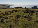

<< Other Photo Pages >> Klusfelsen (Goslar) - Rock Outcrop in Germany in Lower Saxony, Bremen
Submitted by Harald_Platta on Monday, 19 March 2018 Page Views: 1219
Multi-periodSite Name: Klusfelsen (Goslar)Country: Germany Land: Lower Saxony, Bremen Type: Rock Outcrop
Nearest Town: Goslar
Latitude: 51.911944N Longitude: 10.445278E
Condition:
| 5 | Perfect |
| 4 | Almost Perfect |
| 3 | Reasonable but with some damage |
| 2 | Ruined but still recognisable as an ancient site |
| 1 | Pretty much destroyed, possibly visible as crop marks |
| 0 | No data. |
| -1 | Completely destroyed |
| 5 | Superb |
| 4 | Good |
| 3 | Ordinary |
| 2 | Not Good |
| 1 | Awful |
| 0 | No data. |
| 5 | Can be driven to, probably with disabled access |
| 4 | Short walk on a footpath |
| 3 | Requiring a bit more of a walk |
| 2 | A long walk |
| 1 | In the middle of nowhere, a nightmare to find |
| 0 | No data. |
| 5 | co-ordinates taken by GPS or official recorded co-ordinates |
| 4 | co-ordinates scaled from a detailed map |
| 3 | co-ordinates scaled from a bad map |
| 2 | co-ordinates of the nearest village |
| 1 | co-ordinates of the nearest town |
| 0 | no data |
Internal Links:
External Links:
 (PID:179150)")
It is believed that the site might have been a pre-Christian sanctuary. Putative cup-marked stones may indicate its use since the Neolithic.
Reference:
[01] Schmidt, J.K.: Der Klusfelsen in Goslar. In: www.terraner.de (2008).
You may be viewing yesterday's version of this page. To see the most up to date information please register for a free account.
Do not use the above information on other web sites or publications without permission of the contributor.
Nearby Images from Flickr


The above images may not be of the site on this page, but were taken nearby. They are loaded from Flickr so please click on them for image credits.
Click here to see more info for this site
Nearby sites
Click here to view sites on an interactive map of the areaKey: Red: member's photo, Blue: 3rd party photo, Yellow: other image, Green: no photo - please go there and take one, Grey: site destroyed
Download sites to:
KML (Google Earth)
GPX (GPS waypoints)
CSV (Garmin/Navman)
CSV (Excel)
To unlock full downloads you need to sign up as a Contributory Member. Otherwise downloads are limited to 50 sites.
Turn off the page maps and other distractions
Nearby sites listing. In the following links * = Image available
5.5km SSE 152° Kästeklippen* Rock Outcrop
8.8km NW 307° Bredelem Grosssteingrab* Passage Grave
9.0km NW 313° Bredelem Menhir* Standing Stone (Menhir)
12.0km N 353° Scheibenkreuzstein Liebenburg* Early Christian Sculptured Stone
17.1km NE 41° Summstein Hornburg* Modern Stone Circle etc
17.6km NW 317° Steinkreuz Sehlde Ancient Cross
17.7km SW 235° Hübichstein* Rock Outcrop
20.4km S 188° Hanskühnenburg-Klippe* Rock Outcrop
20.5km SSE 167° Dreibrodesteine* Natural Stone / Erratic / Other Natural Feature
20.6km NW 310° Hubertuskapelle* Cave or Rock Shelter
21.1km E 89° Brotstein* Standing Stone (Menhir)
21.2km SE 145° Hexentreppe Wurmberg* Ancient Trackway
21.3km ESE 109° Altenrode* Stone Circle
21.8km SSE 152° Jemerstein* Rock Outcrop
24.5km WSW 249° Infogebäude am römisch-germansichen Schlachtfeld Museum
24.6km ESE 105° Knabenstein Early Christian Sculptured Stone
24.9km ESE 111° Summstein Sonnenstein Modern Stone Circle etc
25.4km SSW 205° Teufelsloch Osterode* Holy Well or Sacred Spring
27.5km NE 35° Remlingen Totenhütte* Chambered Tomb
28.0km SW 222° Lichtensteinhöhle* Cave or Rock Shelter
28.0km SSW 205° Jettenhöhle* Cave or Rock Shelter
28.8km NNE 12° Braunschweigisches Landesmuseum* Museum
29.5km NE 39° Meescheberg* Artificial Mound
30.0km NE 38° Klein Vahlberg Menhir* Standing Stone (Menhir)
30.4km NE 38° Galgenberg von Klein Vahlberg* Artificial Mound
View more nearby sites and additional images


 We would like to know more about this location. Please feel free to add a brief description and any relevant information in your own language.
 Wir möchten mehr über diese Stätte erfahren. Bitte zögern Sie nicht, eine kurze Beschreibung und relevante Informationen in Deutsch hinzuzufügen.
 Nous aimerions en savoir encore un peu sur les lieux. S'il vous plaît n'hesitez pas à ajouter une courte description et tous les renseignements pertinents dans votre propre langue.
 Quisieramos informarnos un poco más de las lugares. No dude en añadir una breve descripción y otros datos relevantes en su propio idioma.