 with our Megalithic Portal iPhone app")


<< Other Photo Pages >> Hübichstein - Rock Outcrop in Germany in Lower Saxony, Bremen
Submitted by Harald_Platta on Sunday, 18 March 2018 Page Views: 889
Natural PlacesSite Name: HübichsteinCountry: Germany
NOTE: This site is 7.034 km away from the location you searched for.
Land: Lower Saxony, Bremen Type: Rock Outcrop
Nearest Town: Bad Grund
Latitude: 51.820125N Longitude: 10.235208E
Condition:
| 5 | Perfect |
| 4 | Almost Perfect |
| 3 | Reasonable but with some damage |
| 2 | Ruined but still recognisable as an ancient site |
| 1 | Pretty much destroyed, possibly visible as crop marks |
| 0 | No data. |
| -1 | Completely destroyed |
| 5 | Superb |
| 4 | Good |
| 3 | Ordinary |
| 2 | Not Good |
| 1 | Awful |
| 0 | No data. |
| 5 | Can be driven to, probably with disabled access |
| 4 | Short walk on a footpath |
| 3 | Requiring a bit more of a walk |
| 2 | A long walk |
| 1 | In the middle of nowhere, a nightmare to find |
| 0 | No data. |
| 5 | co-ordinates taken by GPS or official recorded co-ordinates |
| 4 | co-ordinates scaled from a detailed map |
| 3 | co-ordinates scaled from a bad map |
| 2 | co-ordinates of the nearest village |
| 1 | co-ordinates of the nearest town |
| 0 | no data |
Internal Links:
External Links:
")
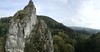
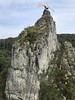
In 1897 it was crowned with an eagle with a three-meter wingspan, which was dedicated as a monument to Kaiser Wilhelm I.
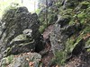
According to local legends, the caves within the rock were inhabitated by the dwarf king Hübich. The Walpurgis Night is still celebrated today at the foot of the rock.
Reference:
[01] Lommatzsch, H.: Iberger Tropfsteinhöhle, Iberg-Winterberg, Hübichenstein : Streifzüge durch vielbesuchte Sehenswürdigkeiten bei Bad Grund (Oberharz). Schriftenreihe Der Harz und Südniedersachsen ; H. 13 : Ser. Harz (1972).
You may be viewing yesterday's version of this page. To see the most up to date information please register for a free account.
Do not use the above information on other web sites or publications without permission of the contributor.
Nearby Images from Flickr
![12.10.2022 Bad Grund [DE] Erzbergwerk Grund](https://farm66.static.flickr.com/65535/52436807537_b3a69569b7_t.jpg)
The above images may not be of the site on this page, but were taken nearby. They are loaded from Flickr so please click on them for image credits.
Click here to see more info for this site
Nearby sites
Click here to view sites on an interactive map of the areaKey: Red: member's photo, Blue: 3rd party photo, Yellow: other image, Green: no photo - please go there and take one, Grey: site destroyed
Download sites to:
KML (Google Earth)
GPX (GPS waypoints)
CSV (Garmin/Navman)
CSV (Excel)
To unlock full downloads you need to sign up as a Contributory Member. Otherwise downloads are limited to 50 sites.
Turn off the page maps and other distractions
Nearby sites listing. In the following links * = Image available
8.6km W 279° Infogebäude am römisch-germansichen Schlachtfeld Museum
11.4km SSW 202° Lichtensteinhöhle* Cave or Rock Shelter
13.3km SSE 163° Teufelsloch Osterode* Holy Well or Sacred Spring
15.3km S 170° Jettenhöhle* Cave or Rock Shelter
15.5km SE 130° Hanskühnenburg-Klippe* Rock Outcrop
17.2km NNE 25° Bredelem Grosssteingrab* Passage Grave
17.7km NE 55° Klusfelsen (Goslar)* Rock Outcrop
17.9km ENE 72° Kästeklippen* Rock Outcrop
18.1km NNE 26° Bredelem Menhir* Standing Stone (Menhir)
21.3km ESE 117° Dreibrodesteine* Natural Stone / Erratic / Other Natural Feature
23.0km SSE 155° Steinkirche* Cave or Rock Shelter
23.2km N 6° Steinkreuz Sehlde Ancient Cross
23.5km N 357° Hubertuskapelle* Cave or Rock Shelter
23.6km SSE 150° Einhornhoehle* Cave or Rock Shelter
24.5km NW 305° Apenteichquellen* Holy Well or Sacred Spring
25.7km NNE 30° Scheibenkreuzstein Liebenburg* Early Christian Sculptured Stone
26.1km SSE 169° Rhumequelle* Holy Well or Sacred Spring
26.2km ESE 110° Jemerstein* Rock Outcrop
27.5km ESE 105° Hexentreppe Wurmberg* Ancient Trackway
28.5km SW 233° Großenrode (2)* Chambered Tomb
28.9km WSW 243° Opferteich Moringen Holy Well or Sacred Spring
32.6km SE 142° Steina Monolith Natural Stone / Erratic / Other Natural Feature
34.5km NE 48° Summstein Hornburg* Modern Stone Circle etc
34.7km E 85° Altenrode* Stone Circle
37.1km ENE 73° Brotstein* Standing Stone (Menhir)
View more nearby sites and additional images


 We would like to know more about this location. Please feel free to add a brief description and any relevant information in your own language.
 Wir möchten mehr über diese Stätte erfahren. Bitte zögern Sie nicht, eine kurze Beschreibung und relevante Informationen in Deutsch hinzuzufügen.
 Nous aimerions en savoir encore un peu sur les lieux. S'il vous plaît n'hesitez pas à ajouter une courte description et tous les renseignements pertinents dans votre propre langue.
 Quisieramos informarnos un poco más de las lugares. No dude en añadir una breve descripción y otros datos relevantes en su propio idioma.