

<< Text Pages >> Dolmen dit la Pierre de Sainte-Radegonde - Burial Chamber or Dolmen in France in Normandie:Eure (27)
Submitted by holger_rix on Saturday, 26 March 2016 Page Views: 1218
Neolithic and Bronze AgeSite Name: Dolmen dit la Pierre de Sainte-RadegondeCountry: France
NOTE: This site is 1.43 km away from the location you searched for.
Département: Normandie:Eure (27) Type: Burial Chamber or Dolmen
Nearest Town: Les Andelys Nearest Village: Giverny
Latitude: 49.077659N Longitude: 1.523134E
Condition:
| 5 | Perfect |
| 4 | Almost Perfect |
| 3 | Reasonable but with some damage |
| 2 | Ruined but still recognisable as an ancient site |
| 1 | Pretty much destroyed, possibly visible as crop marks |
| 0 | No data. |
| -1 | Completely destroyed |
| 5 | Superb |
| 4 | Good |
| 3 | Ordinary |
| 2 | Not Good |
| 1 | Awful |
| 0 | No data. |
| 5 | Can be driven to, probably with disabled access |
| 4 | Short walk on a footpath |
| 3 | Requiring a bit more of a walk |
| 2 | A long walk |
| 1 | In the middle of nowhere, a nightmare to find |
| 0 | No data. |
| 5 | co-ordinates taken by GPS or official recorded co-ordinates |
| 4 | co-ordinates scaled from a detailed map |
| 3 | co-ordinates scaled from a bad map |
| 2 | co-ordinates of the nearest village |
| 1 | co-ordinates of the nearest town |
| 0 | no data |
Be the first person to rate this site - see the 'Contribute!' box in the right hand menu.
Internal Links:
External Links:
Burial Chamber (Dolmen) in Normandie:Eure (27)
Rue Claude Monet, Giverny, Les Andelys, Eure, Normandie
Source: T4T35.fr
You may be viewing yesterday's version of this page. To see the most up to date information please register for a free account.
Do not use the above information on other web sites or publications without permission of the contributor.
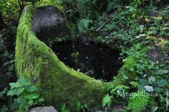
Nearby Images from Flickr

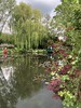
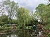
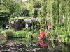
The above images may not be of the site on this page, but were taken nearby. They are loaded from Flickr so please click on them for image credits.
Click here to see more info for this site
Nearby sites
Click here to view sites on an interactive map of the areaKey: Red: member's photo, Blue: 3rd party photo, Yellow: other image, Green: no photo - please go there and take one, Grey: site destroyed
Download sites to:
KML (Google Earth)
GPX (GPS waypoints)
CSV (Garmin/Navman)
CSV (Excel)
To unlock full downloads you need to sign up as a Contributory Member. Otherwise downloads are limited to 50 sites.
Turn off the page maps and other distractions
Nearby sites listing. In the following links * = Image available
3.3km NW 322° Camp de Mortagne Hillfort
5.0km SSE 161° La Roche Galerne Passage Grave
6.2km SE 135° Allée couverte de Bonnières-sur-Seine Passage Grave
7.7km WNW 302° St-Pierre-d'Autils grotte sepulchral Cave or Rock Shelter
7.8km NW 306° Trou aux Anglais (St-Pierre-d'Autils) Ancient Village or Settlement
9.9km NE 40° Bus-St-Remy burial chamber Burial Chamber or Dolmen
10.6km ENE 78° Allée couverte de Bézu Passage Grave
11.8km W 260° Houlbec-Cocherel burial chamber Burial Chamber or Dolmen
13.9km SSW 208° Pierre Frite de Breuilpont Standing Stone (Menhir)
14.0km NW 319° Menhir dit Gravier de Gargantua (Chateau-Neuf)* Standing Stone (Menhir)
14.3km NE 40° Allée Couverte de Dampsmesnil* Passage Grave
14.3km NW 317° Tombeau de Saint-Ethbin* Burial Chamber or Dolmen
15.1km ESE 114° Dennemont Passage Grave
15.2km NE 51° Vielle Cote Dolmen* Passage Grave
15.5km S 180° Menhir de la Pierre Grise* Standing Stone (Menhir)
17.5km NW 306° Aubevoye Dolmen Burial Chamber or Dolmen
17.7km NE 40° Allée Couverte du Fayel Passage Grave
17.7km SW 234° Menhir dit le Caillou de Gargantua Standing Stone (Menhir)
17.8km E 97° Drocourt Menhir Standing Stone (Menhir)
19.6km SSW 198° Garennes-sur-Eure Menhir* Standing Stone (Menhir)
20.2km ESE 112° Croix des Fleurions Menhir christianisé* Standing Stone (Menhir)
20.3km NNW 338° monument druidique Burial Chamber or Dolmen
20.5km SSE 160° La Lapiniere Passage Grave
20.7km ESE 114° Menhir dit la Pierre-Drette (Guitrancourt)* Standing Stone (Menhir)
21.4km SE 134° Les Maudhuits Passage Grave
View more nearby sites and additional images


 We would like to know more about this location. Please feel free to add a brief description and any relevant information in your own language.
 Wir möchten mehr über diese Stätte erfahren. Bitte zögern Sie nicht, eine kurze Beschreibung und relevante Informationen in Deutsch hinzuzufügen.
 Nous aimerions en savoir encore un peu sur les lieux. S'il vous plaît n'hesitez pas à ajouter une courte description et tous les renseignements pertinents dans votre propre langue.
 Quisieramos informarnos un poco más de las lugares. No dude en añadir una breve descripción y otros datos relevantes en su propio idioma.