


<< Other Photo Pages >> Devil's Dyke (Norfolk) - Misc. Earthwork in England in Norfolk
Submitted by coldrum on Tuesday, 11 August 2009 Page Views: 5337
Multi-periodSite Name: Devil's Dyke (Norfolk) Alternative Name: Rowdike, Rowdych, Devils DykeCountry: England
NOTE: This site is 2.252 km away from the location you searched for.
County: Norfolk Type: Misc. Earthwork
Map Ref: TF8934705200
Latitude: 52.611561N Longitude: 0.795169E
Condition:
| 5 | Perfect |
| 4 | Almost Perfect |
| 3 | Reasonable but with some damage |
| 2 | Ruined but still recognisable as an ancient site |
| 1 | Pretty much destroyed, possibly visible as crop marks |
| 0 | No data. |
| -1 | Completely destroyed |
| 5 | Superb |
| 4 | Good |
| 3 | Ordinary |
| 2 | Not Good |
| 1 | Awful |
| 0 | No data. |
| 5 | Can be driven to, probably with disabled access |
| 4 | Short walk on a footpath |
| 3 | Requiring a bit more of a walk |
| 2 | A long walk |
| 1 | In the middle of nowhere, a nightmare to find |
| 0 | No data. |
| 5 | co-ordinates taken by GPS or official recorded co-ordinates |
| 4 | co-ordinates scaled from a detailed map |
| 3 | co-ordinates scaled from a bad map |
| 2 | co-ordinates of the nearest village |
| 1 | co-ordinates of the nearest town |
| 0 | no data |
Be the first person to rate this site - see the 'Contribute!' box in the right hand menu.
Internal Links:
External Links:
Misc. Earthwork in Norfolk
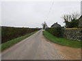
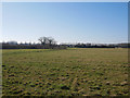
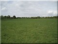
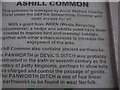
"This feature is a linear earthwork, ditched, or once ditched, on the west. South of the road it survives only in vestigial form for a short stretch as a field boundary, and it terminates at the north at an east-west hedgerow. No traces could be seen in the arable field beyond. The purpose and period of construction of this work cannot be determined." - Pastscape monument no. 357730.
You may be viewing yesterday's version of this page. To see the most up to date information please register for a free account.
Do not use the above information on other web sites or publications without permission of the contributor.
coldrum has found this location on Google Street View:
Nearby Images from Geograph Britain and Ireland:
©2019(licence)
©2019(licence)
©2018(licence)
©2007(licence)
©2018(licence)
The above images may not be of the site on this page, they are loaded from Geograph.
Please Submit an Image of this site or go out and take one for us!
Click here to see more info for this site
Nearby sites
Key: Red: member's photo, Blue: 3rd party photo, Yellow: other image, Green: no photo - please go there and take one, Grey: site destroyed
Download sites to:
KML (Google Earth)
GPX (GPS waypoints)
CSV (Garmin/Navman)
CSV (Excel)
To unlock full downloads you need to sign up as a Contributory Member. Otherwise downloads are limited to 50 sites.
Turn off the page maps and other distractions
Nearby sites listing. In the following links * = Image available
6.1km S 181° Merton Stone* Natural Stone / Erratic / Other Natural Feature (TL895991)
7.3km SSW 208° Little Cressingham Barrow Cemetery* Barrow Cemetery (TL861986)
9.2km W 267° Cockley Cley Iceni Village* Museum (TF802043)
9.8km W 266° St Mary’s Chapel, Cockley Cley* Ancient Temple (TF79550411)
12.0km NNE 29° St Agnes Well, Longham* Holy Well or Sacred Spring (TF94831586)
12.3km NE 51° St Withburga's Well* Holy Well or Sacred Spring (TF9865213305)
12.5km SW 216° Lynford Middle Paleolithic Site* Not Known (by us) (TL82409484)
15.1km NNW 347° Weasenham Plantation* Barrow Cemetery (TF853198)
15.3km N 351° Litcham Heath* Round Barrow(s) (TF863202)
16.5km S 189° Mickle Hill Tumulus* Round Barrow(s) (TL873888)
17.2km S 176° East Wretham Heath Earthwork* Misc. Earthwork (TL91278814)
17.2km SSW 209° Grime's Graves Flint Mines* Ancient Mine, Quarry or other Industry (TL817898)
17.5km SSE 159° Larling Heath Tumulus Round Barrow(s) (TL96268912)
17.5km SSW 208° Grimes Puddingstone Marker Stone (TL816895)
17.5km SSW 213° Grimes Graves Barrows* Round Barrow(s) (TL804901)
18.3km N 10° Whissonsett wheel-head cross* Ancient Cross (TF91922334)
18.3km SSW 199° Blood Hill* Round Barrow(s) (TL84078765)
18.5km S 170° Peddars Way* Ancient Trackway (TL9341287119)
19.0km NNE 32° North Elmham Chapel* Ancient Temple (TF9888121640)
19.2km SE 143° Gallows Hill Tumulus Round Barrow(s) (TM01419019)
20.0km SW 214° Pepper Hill* Round Barrow(s) (TL787882)
21.1km SSE 160° Mickelmoor Hill Settlement Ancient Village or Settlement (TL974857)
21.2km NNW 341° West Rudham* Round Barrow(s) (TF81652495)
21.5km ESE 102° St Thomas's Well (Wymondham)* Holy Well or Sacred Spring (TG10550146)
21.6km SSW 212° Brandon Heritage Museum Museum (TL785865)
View more nearby sites and additional images


 We would like to know more about this location. Please feel free to add a brief description and any relevant information in your own language.
 Wir möchten mehr über diese Stätte erfahren. Bitte zögern Sie nicht, eine kurze Beschreibung und relevante Informationen in Deutsch hinzuzufügen.
 Nous aimerions en savoir encore un peu sur les lieux. S'il vous plaît n'hesitez pas à ajouter une courte description et tous les renseignements pertinents dans votre propre langue.
 Quisieramos informarnos un poco más de las lugares. No dude en añadir una breve descripción y otros datos relevantes en su propio idioma.