

<< Our Photo Pages >> Dolmen de Tella - Burial Chamber or Dolmen in Spain in Aragón
Submitted by TheCaptain on Thursday, 10 February 2005 Page Views: 7417
Neolithic and Bronze AgeSite Name: Dolmen de Tella Alternative Name: La Piedra De Vasar TrikuharriaCountry: Spain
NOTE: This site is 4.267 km away from the location you searched for.
Region: Aragón Type: Burial Chamber or Dolmen
Nearest Town: Bielsa Nearest Village: Tella
Latitude: 42.579910N Longitude: 0.179260E
Condition:
| 5 | Perfect |
| 4 | Almost Perfect |
| 3 | Reasonable but with some damage |
| 2 | Ruined but still recognisable as an ancient site |
| 1 | Pretty much destroyed, possibly visible as crop marks |
| 0 | No data. |
| -1 | Completely destroyed |
| 5 | Superb |
| 4 | Good |
| 3 | Ordinary |
| 2 | Not Good |
| 1 | Awful |
| 0 | No data. |
| 5 | Can be driven to, probably with disabled access |
| 4 | Short walk on a footpath |
| 3 | Requiring a bit more of a walk |
| 2 | A long walk |
| 1 | In the middle of nowhere, a nightmare to find |
| 0 | No data. |
| 5 | co-ordinates taken by GPS or official recorded co-ordinates |
| 4 | co-ordinates scaled from a detailed map |
| 3 | co-ordinates scaled from a bad map |
| 2 | co-ordinates of the nearest village |
| 1 | co-ordinates of the nearest town |
| 0 | no data |
Internal Links:
External Links:
I have visited· I would like to visit
43559959 would like to visit
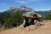
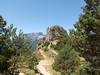
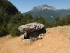
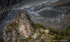
TheCaptain visited on 8th Sep 2000 - their rating: Cond: 3 Amb: 5 Access: 4 Ten days touring and exploring in the Pyrenees. Drive from St-Lary-Soulan through the Tunnel de Bielsa into Spain. Bielsa, Tella, Ainsa, then long way to Torla-Ordesa. this is a magnificently situated dolmen, high up on the mountainside below the village of Tella in the Spanish Pyrenees. A few miles to the south of Bielsa, a road climbs towards the top of the mountain with the ancient village of Tella at the top. Before reaching the top, there is this most spectacularly situated dolmen.
")
A few miles to the south of Bielsa, a road climbs towards the top of the mountain with the ancient village of Tella at the top. Before reaching the top, there is this most spectacularly situated dolmen.
You may be viewing yesterday's version of this page. To see the most up to date information please register for a free account.
")
")
")
")
Do not use the above information on other web sites or publications without permission of the contributor.
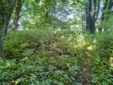
Nearby Images from Flickr
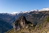
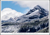
The above images may not be of the site on this page, but were taken nearby. They are loaded from Flickr so please click on them for image credits.
Click here to see more info for this site
Nearby sites
Click here to view sites on an interactive map of the areaKey: Red: member's photo, Blue: 3rd party photo, Yellow: other image, Green: no photo - please go there and take one, Grey: site destroyed
Download sites to:
KML (Google Earth)
GPX (GPS waypoints)
CSV (Garmin/Navman)
CSV (Excel)
To unlock full downloads you need to sign up as a Contributory Member. Otherwise downloads are limited to 50 sites.
Turn off the page maps and other distractions
Nearby sites listing. In the following links * = Image available
624m NNW 346° Fandichuerre Dolmen* Burial Chamber or Dolmen
7.4km NW 316° Cromlech de Gurrundué* Stone Circle
11.4km ESE 102° Collado Del Ibón Stone Circle
11.5km ESE 103° Collata De Labasar 7* Stone Circle
11.5km ESE 103° Collata De Labasar 1-6* Stone Circle
15.5km ESE 115° Armeña Túmulo Round Barrow(s)
18.2km E 93° Collado de Sahún* Stone Circle
18.7km E 93° La Bocona Chromlechs 1+2* Stone Circle
19.0km N 3° Saux burial chamber* Burial Chamber or Dolmen
23.1km ESE 122° Seira Dolmen* Burial Chamber or Dolmen
26.4km E 100° Espía Dolmen* Burial Chamber or Dolmen
32.4km SSW 199° La Capilleta Dolmen* Burial Chamber or Dolmen
32.5km NE 36° Armenteule Menhir* Standing Stone (Menhir)
32.6km SSW 197° Pueyoril Dolmen* Burial Chamber or Dolmen
34.0km NE 34° Aneran stone* Standing Stone (Menhir)
34.4km SSW 196° Caseta de las Balanzas Dolmen* Burial Chamber or Dolmen
34.9km NW 305° Los Batanes Túmulo Round Barrow(s)
35.2km NW 306° Los Batanes Chromlech* Stone Circle
35.2km SSE 159° Dolmen de Perarrúa Burial Chamber or Dolmen
36.4km NNW 345° Dolmen dit la Cabane du Loup Burial Chamber or Dolmen
36.6km ENE 72° Remuñe Cromlech* Chambered Cairn
36.7km NNE 27° Menhir de Bordères-Louron Standing Stone (Menhir)
36.7km ENE 72° Remuñe Tumulus* Round Barrow(s)
36.9km SE 137° Merli Menhir* Standing Stone (Menhir)
36.9km ENE 72° Forau de la Llana* Stone Circle
View more nearby sites and additional images


 We would like to know more about this location. Please feel free to add a brief description and any relevant information in your own language.
 Wir möchten mehr über diese Stätte erfahren. Bitte zögern Sie nicht, eine kurze Beschreibung und relevante Informationen in Deutsch hinzuzufügen.
 Nous aimerions en savoir encore un peu sur les lieux. S'il vous plaît n'hesitez pas à ajouter une courte description et tous les renseignements pertinents dans votre propre langue.
 Quisieramos informarnos un poco más de las lugares. No dude en añadir una breve descripción y otros datos relevantes en su propio idioma.